Náquera / Nàquera facts for kids
Quick facts for kids
Náquera
Nàquera (Valencian)
|
|||
|---|---|---|---|
| Nàquera / Náquera | |||

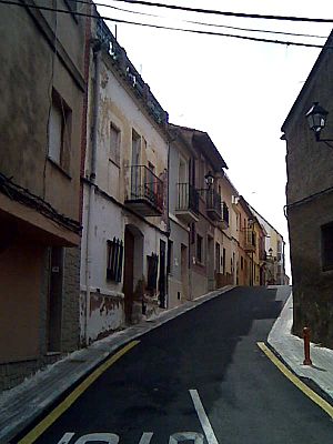
Street in Náquera.jpg
|
|||
|
|||
| Country | |||
| Autonomous community | |||
| Province | Valencia | ||
| Comarca | Camp de Túria | ||
| Judicial district | Llíria | ||
| Area | |||
| • Total | 38.7 km2 (14.9 sq mi) | ||
| Elevation | 242 m (794 ft) | ||
| Population
(2018)
|
|||
| • Total | 6,205 | ||
| • Density | 160.34/km2 (415.3/sq mi) | ||
| Demonym(s) | Naquerà, Naquerana | ||
| Time zone | UTC+1 (CET) | ||
| • Summer (DST) | UTC+2 (CEST) | ||
| Postal code |
46119
|
||
| Official language(s) | Valencian | ||
Náquera (pronounced NAH-keh-rah), also known as Nàquera in Valencian, is a small town in Spain. It's located in the Valencian Community, which is a region in the eastern part of the country. Náquera is part of the Camp de Túria area, and it's about 24 kilometers (15 miles) northeast of the big city of Valencia. The town is known for its beautiful natural surroundings. Its main church is called Nuestra Señora de la Encarnación.
Contents
Where is Náquera?
Náquera is nestled at the bottom of the Sierra Calderona mountains. People often call it the "door to the Calderona" because of its location. The town sits on the side of a small hill, about 215 meters (705 feet) high. A small stream called the Naquera Creek runs through it.
A Town of Villas
As you approach Náquera, you'll see many farms and pretty residential areas. These areas have lots of small villas or chalets. Many people own these homes and use them for weekend getaways or summer holidays.
Natural Park Connection
The total area of Náquera is about 38.7 square kilometers (14.9 square miles). A big part of this area, about 10.2 square kilometers (3.9 square miles), is actually inside the Sierra Calderona Natural Park. This means Náquera is very close to a protected natural area.
Náquera's Climate
Náquera has a special kind of Mediterranean climate. It's a bit like a steppe climate, which means it can be cold and semi-dry. The average temperature for the year is a mild 16°C (61°F).
Temperature and Rainfall
The warmest month is usually August, with daily temperatures around 33°C (91°F). The coldest month is February, where temperatures average about 9°C (48°F). Náquera doesn't get a lot of rain, only about 457 millimeters (18 inches) per year. Most of the rain falls in October, and July is usually the driest month.
Nature and Farming
This climate has been good for farming, especially for growing citrus fruits like oranges. Before, people grew crops that didn't need much rain. The areas that aren't farmed are very green and full of trees. You can find lots of local Mediterranean plants, like the Holm Oak tree, and many different kinds of wildlife.
Nearby Towns
Náquera shares its borders with several other towns in the Valencia province. These include:
- Albalat de Tarongers (to the west)
- Bétera (to the south)
- Moncada (to the southwest)
- Museros (to the east)
- El Puig (to the east-northeast)
- Rafelbunyol (to the northeast)
- Sagunto (to the north-northeast)
- Segart (to the north)
- Serra (to the north)
How to Get to Náquera
There are several ways to reach Náquera, especially if you are coming from the city of Valencia:
- You can take the V-21 highway, then switch to the CV-35, and finally the CV-305/315 roads.
- Another option is to use the A-7 highway and take specific exits like 313, 315, or 321, then follow the local roads like CV-305/315 or CV-310.
- You can also use the CV-315 road, which is known as Camino de Moncada, coming from Valencia.
- From the north, you can drive through Serra from Torres-Torres using the CV-310 road. This route is very scenic and climbs up to 525 meters (1,722 feet) above sea level. You can even take a short detour to visit a place called Garbí.
Famous People from Náquera
- Francisco Javier Cabo (1768-1832) was a well-known composer and musician. He was born in Náquera.
See also
 In Spanish: Náquera para niños


