Nacmine, Alberta facts for kids
Quick facts for kids
Nacmine
|
|
|---|---|
|
Former hamlet
|
|
| Country | Canada |
| Province | Alberta |
| Municipality | Town of Drumheller |
| Time zone | UTC−7 (MST) |
| • Summer (DST) | UTC−6 (MDT) |
| Area code(s) | 403, 587, 825 |
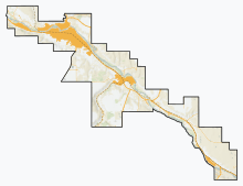
Nacmine is a small community located in Alberta, Canada. It is now part of the Town of Drumheller. Before 1998, Nacmine was known as a hamlet. A hamlet is a small settlement, usually smaller than a village.
On January 1, 1998, Nacmine joined with the former City of Drumheller. This process is called amalgamation, which means two or more places combine to form one larger area. This made Nacmine a community within the larger Town of Drumheller.
Where is Nacmine Located?
Nacmine is found in the beautiful Red Deer River valley. You can reach it by traveling on South Dinosaur Trail, also known as Highway 575.
It is about 5 kilometers (3 miles) west of Drumheller's main town area. If you're coming from Calgary, Nacmine is about 112 kilometers (70 miles) to the northeast. The community is part of a larger area called Census Division No. 5. It is also in the federal voting area known as Crowfoot.
How Has Nacmine's Population Changed?
The number of people living in Nacmine has changed quite a bit over the years. We can see this by looking at historical population records. These records help us understand how communities grow or shrink.
|
|||||||||||||||||||||||||||||||||||||||||||||
For example, in 1941, there were 483 people living in Nacmine. The population grew to 547 by 1951. However, it then saw a decrease in the following years. By 1961, the population was 285.
After that, the numbers started to go up again. In 1991, there were 447 residents. By 2001, Nacmine had 513 people. These numbers show how the community has changed in size over many decades.
 | Percy Lavon Julian |
 | Katherine Johnson |
 | George Washington Carver |
 | Annie Easley |


