Nagjuttuuq facts for kids

Nagjuttuuq, Nunavut.
|
|
| Geography | |
|---|---|
| Location | Foxe Basin |
| Coordinates | 65°52′27″N 83°53′35″W / 65.87417°N 83.89306°W |
| Archipelago | Arctic Archipelago |
| Area | 997 km2 (385 sq mi) |
| Administration | |
|
Canada
|
|
| Nunavut | Nunavut |
| Region | Kivalliq |
| Demographics | |
| Population | 0 |
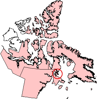
Nagjuttuuq (which is ᓇᒡᔪᑦᑑᖅ in Inuktitut syllabics) used to be called Vansittart Island. It is one of the many islands in the Arctic Archipelago that belong to Canada. This island is found in the Kivalliq Region of Nunavut, Canada.
Nagjuttuuq is located in a large body of water called Foxe Basin. It lies just north of Southampton Island. The island is quite large, covering an area of about 997 square kilometers. No one lives on Nagjuttuuq Island.
Contents
Where is Nagjuttuuq Island?
Nagjuttuuq Island is part of Canada's vast Arctic Archipelago. This is a huge group of islands in the Arctic Ocean. The island is specifically located in Nunavut, which is a territory in northern Canada.
Foxe Basin: Nagjuttuuq's Home
The island sits in the middle of Foxe Basin. This is a large, shallow body of water found in the Canadian Arctic. It is known for its cold waters and often has sea ice for much of the year. The basin is an important area for many Arctic animals.
How Big is Nagjuttuuq?
Nagjuttuuq Island measures about 997 square kilometers (which is about 385 square miles). To give you an idea, that's roughly the size of a large city or a small country. Despite its size, the island remains uninhabited.
Why is Nagjuttuuq Uninhabited?
Like many islands in the Canadian Arctic, Nagjuttuuq is uninhabited. This means no people live there permanently. The main reason for this is the very harsh Arctic climate. Winters are extremely cold and long, and the landscape is mostly tundra. This makes it a challenging place for humans to live.
See also
 In Spanish: Isla Vansittart para niños
 | John T. Biggers |
 | Thomas Blackshear |
 | Mark Bradford |
 | Beverly Buchanan |


