
National Register of Historic Places listings in Amite County, Mississippi facts for kids

Welcome to Amite County, Mississippi! This page is all about special places here that are listed on the National Register of Historic Places. The National Register is like a big official list kept by the United States government. It helps protect important buildings, sites, and objects that have a lot of history.
When a place is on this list, it means it's really special. It could be important for its history, its amazing architecture, or because of famous people or events connected to it. In Amite County, there are 19 places currently on this list. One other place was on the list but has since been removed. Let's explore some of these cool historic spots!
Contents
What is the National Register of Historic Places?
The National Register of Historic Places is the official list of the nation's historic places worth saving. It is part of a program to coordinate and support public and private efforts to identify, evaluate, and protect America's historic and archaeological resources. Think of it as a way to make sure important parts of our past are kept safe for future generations.
Why are places added to the Register?
Places get added to the National Register for many reasons. They might be very old, show a unique style of building, or be linked to important events or people. For example, a courthouse might be listed because it's where important laws were made. A school could be listed if it played a big role in education history.
Historic Places in Amite County
Amite County has many interesting places that tell stories about its past. These sites include old courthouses, schools, churches, and homes. Each one helps us understand what life was like long ago.
Important Buildings in Liberty
The town of Liberty is home to several historic buildings. These include the county courthouse and an old seminary.
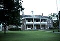
Amite County Courthouse
The Amite County Courthouse is a very important building. It is located on Main Street in Liberty. This courthouse was added to the National Register in 1974. Courthouses are often central to a county's history. They are where local government decisions are made.
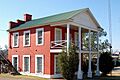
Amite Female Seminary
Another historic spot in Liberty is the Amite Female Seminary. This building is found on Mississippi Highway 569. It was listed in 1980. A seminary is a school, and this one was for young women. It shows the history of education in the area.
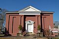
Liberty Presbyterian Church
The Liberty Presbyterian Church is on North Church Street in Liberty. It was added to the list in 1985. Churches are often important community centers. They also show the history of faith in a region.
Historic Homes and Plantations
Many old homes and plantations in Amite County are also on the National Register. These places give us a peek into how people lived in the past.
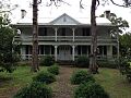
Wilford Zachariah Lea House
The Wilford Zachariah Lea House is about two miles north of Liberty. It is on Mississippi Highway 569. This house was listed in 1995. It is a great example of historic homes in the area.
Other Notable Homes
Several other houses are also listed. These include the Thomas Batchelor House and the Decatur N. Butler House. The Felder-Richmond House and Hampton Lea House are near Magnolia. The McGehee House and Theodore L. McGehee Plantation House are also recognized. Pinewood and the George Webb House are other historic homes near Liberty. Each of these homes has its own unique story.
Schools and Community Sites
Beyond homes and churches, other types of buildings hold historical value. These include schools and other community places.
Bethany Institute and Church
Near Centreville, you can find the Bethany Institute and Bethany Presbyterian Church. The Institute was listed in 1978, and the Church in 2003. These sites show the importance of education and religion in the community's past.
Sherman Line Rosenwald School
The Sherman Line Rosenwald School is near Magnolia. It was added to the Register in 2017. Rosenwald Schools were special schools built for African American children in the early 20th century. They were built with help from Julius Rosenwald, who was the head of Sears, Roebuck and Company. These schools played a huge role in education history.
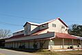
Westbrook Cotton Gin
The Westbrook Cotton Gin is located on Gillsburg Road in Liberty. It was listed in 2010. A cotton gin is a machine that separates cotton fibers from their seeds. This machine was very important for farming and the economy in the South. It shows the history of agriculture in Amite County.
Unique Historical Sites
Some listings are not buildings but other types of historical sites.
Sturdivant Fishweir
The Sturdivant Fishweir is a unique archaeological site near Rosetta. It was listed in 1978. A fishweir is an ancient structure used to trap fish. This site tells us about how people lived and found food a very long time ago. Its exact location is kept secret to protect it.
Former Listing
Sometimes, a property is removed from the National Register. This can happen if the building is destroyed or loses its historical importance.
Talbert-Cassels House
The Talbert-Cassels House near Gloster was once on the National Register. It was listed in 1984. Sadly, this house was destroyed by a fire in December 2006. Because it was no longer standing, it was removed from the list in 2008.
Images for kids
-
The Amite County Courthouse in Liberty.
-
The historic Amite Female Seminary building.
-
The Wilford Zachariah Lea House.
-
The Liberty Presbyterian Church.
-
The Westbrook Cotton Gin in Liberty.


