
National Register of Historic Places listings in Angelina County, Texas facts for kids

Angelina County, located in the eastern part of Texas, is home to many interesting and important places. These special spots are listed on the National Register of Historic Places. This list helps protect buildings, structures, and sites that tell us about the past. It's like a special club for places that have a lot of history!
Contents
Historic Places in Angelina County
The National Register of Historic Places is the official list of the United States' historic sites. It's managed by the National Park Service. When a place is added to this list, it means it's important to the history of the local area, the state, or even the whole country. This list helps people learn about and save these special places for future generations.
Most of Angelina County's historic places are found in the city of Lufkin. These include old homes, businesses, and even a bridge! Each place has its own story, showing us how people lived and worked long ago.
Amazing Historic Homes in Lufkin
Many of the buildings on the list are beautiful old houses. These homes show different styles of architecture from the past. They often belonged to important families or people who helped build the community.
Grand Houses with History
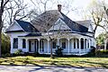
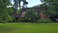
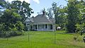
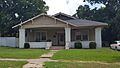
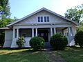
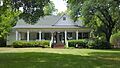
- Abercrombie-Cavanaugh House: Located at 304 Paul Ave. in Lufkin, this house was added to the list in 1988.
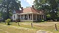
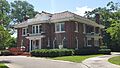
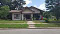
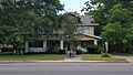
- Banks-Ogg House: You can find this historic home at 602 E Groesbeck St. in Lufkin. It also joined the list in 1988.
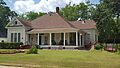
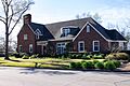
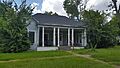
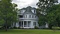
- Behannon-Kenley House: This house at 317 Shepherd Ave. in Lufkin is another historic gem from 1988.
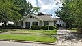
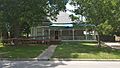
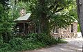
- Binion-Casper House: Found at 404 Mantooth Ave. in Lufkin, this home was recognized in 1989.
- Bowers-Felts House: At 1213 Lotus Ln. in Lufkin, this house became historic in 1988.
- Boynton-Kent House: Located at 107 W Kerr St. in Lufkin, this home also joined the list in 1988.
- Houston Brookshire-Yeates House: This house at 304 E Howe St. in Lufkin was added in 1988.
- Byus-Kirkland House: At 411 Mantooth Ave. in Lufkin, this house was recognized in 1988.
- Clark-Whitton House: Found at 1865 Old Mill Rd. in Lufkin, this home joined the list in 1988.
- Everitt-Cox House: This house at 418 Moore Ave. in Lufkin was added in 1988.
- Humason-Pinkerton House: Located at 602 Grove Ave. in Lufkin, this home became historic in 1988.
- A. C. Kennedy-Runnells House: You can find this house at 603 E Groesbeck St. in Lufkin. It was listed in 1988.
- R. A. Kennedy-J. M. Lowrey House: This home at 519 E Groesbeck St. in Lufkin also joined the list in 1988.
- J. H. Kurth House: At 1860 Old Mill Rd. in Lufkin, this house was recognized in 1988.
- Kurth-Glover House: Found at 1847 Old Mill Rd. in Lufkin, this home was added in 1988.
- G. E. Lawrence House: This house at 2005 S Chestnut St. in Lufkin became historic in 1988.
- Lufkin Land-Long Bell-Buck House: Located at 1218 Lufkin St. in Lufkin, this home was listed in 1988.
- Marsh-Smith House: At 503 N Raguet St. in Lufkin, this house joined the list in 1988.
- Newsom-Moss House: This home at 420 Mantooth Ave. in Lufkin was added in 1988.
- Parker-Bradshaw House: Found at 213 N Raguet St. in Lufkin, this house became historic in 1988.
- Dr. Edward Percy-Abney House: Located at 466 Jefferson Ave. in Lufkin, this home was listed in 1988.
- A. F. Perry and Myrtle-Pitmann House: At 402 S Bynum St. in Lufkin, this house joined the list in 1988.
- C. W. Perry Archie-Hallmark House: This home at 302 S. Bynum in Lufkin was added in 1988.
- Walter C. Trout-White House: Found at 444 Jefferson Ave. in Lufkin, this house became historic in 1988.
- Howard Walker House: Located at 503 Harmony Hill Rd. in Lufkin, this home was listed in 1988.
Worker Housing
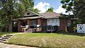
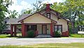
- Keltys Worker Housing: This unique historic site at 109 Maas in Lufkin was added in 1988. It represents homes built for workers in the Keltys community.
Houses Outside Lufkin
- Gibbs-Flournoy House: This house is located on Farm to Market Road 844 in Manning. It was added to the list in 1988.
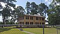
- Henry G. Temple House: Found at 501 Hines Rd. in Diboll, this house also joined the list in 1988.
Other Cool Historic Spots
Angelina County also has other types of historic places, not just houses. These include old bridges, commercial buildings, and even a courthouse.
Buildings with a Story
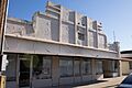
- Corstone Sales Company: This commercial building at 109-111 E Shepherd St. in Lufkin was listed in 1988. It shows how businesses operated in the past.
- Fenley Commercial Building: Located at 112 E Lufkin Ave. in Lufkin, this building also became historic in 1988.
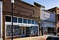
- McClendon-Abney Hardware Company: This old hardware store at 119 E Lufkin Ave. in Lufkin was added to the list in 1988.
- Pines Theatre: Found at 113 S First St. in Lufkin, this theater was listed in 1988. Imagine all the movies and shows people watched here!
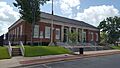
- Ward R. Burke U.S. Courthouse: Also known as the Old Federal Building, this important building at 104 N Third St. in Lufkin was recognized in 1988. It served as a place for legal matters.
- Texas Highway Department Complex: This site at 110 Forest Park in Lufkin includes six buildings. It was added to the list in 1988 and shows the history of road building in the area.
Bridges and More
- Angelina River Bridge: This bridge on US 59 over the Angelina River near Lufkin was listed in 1988. It was an important crossing point, though the original bridge was replaced in 1998.
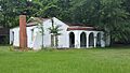
- Dunham Hill: Located on US 69 west of Huntington, this site was added to the list in 1988.
Images for kids
-
The Abercrombie-Cavanaugh House in Lufkin.
-
The Banks-Ogg House.
-
The Behannon-Kenley House.
-
The Binion-Casper House.
-
The Bowers-Felts House.
-
The Boynton-Kent House.
-
The Houston Brookshire-Yeates House.
-
The Byus-Kirkland House.
-
The Clark-Whitton House.
-
The Corstone Sales Company building.
-
The Everitt-Cox House.
-

The Fenley Commercial Building.
-
The Humason-Pinkerton House.
-

Keltys Worker Housing.
-
The A. C. Kennedy-Runnells House.
-
The R. A. Kennedy-J. M. Lowrey House.
-
The J. H. Kurth House.
-

The Kurth-Glover House.
-
The G. E. Lawrence House.
-
The Lufkin Land-Long Bell-Buck House.
-
The Marsh-Smith House.
-
The McClendon-Abney Hardware Company.
-
The Newsom-Moss House.
-
The Ward R. Burke U.S. Courthouse.
-
The Parker-Bradshaw House.
-
The Dr. Edward Percy-Abney House.
-
The A. F. Perry and Myrtle-Pitmann House.
-

The C. W. Perry Archie-Hallmark House.
-
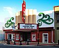
The Pines Theatre.
-
The Texas Highway Department Complex.
-

The Walter C. Trout-White House.
.jpg)


.jpg)


.jpg)


.jpg)


.jpg)


