
National Register of Historic Places listings in Ashland County, Ohio facts for kids

Have you ever wondered about old buildings or places that have a special history? In the United States, there's a list called the National Register of Historic Places. It's like a special club for buildings, sites, and objects that are important to American history, architecture, archaeology, engineering, or culture. When a place is added to this list, it means it's recognized as valuable and worth protecting for future generations.
This article is about the historic places in Ashland County, Ohio, that are on this special list. There are 19 places currently listed, and two more were once on the list but have since been removed.
Contents
What is the National Register of Historic Places?
The National Register of Historic Places is the official list of the nation's historic places. It's part of a program run by the National Park Service. Its main goal is to help people understand and protect important historic sites. When a place is listed, it gets some benefits, like special consideration in planning projects and sometimes even grants for preservation. It also helps people learn about the history of their local area.
Historic Places in Ashland County
Ashland County is home to many interesting historic sites. These places tell stories about the past, from old schoolhouses to grand courthouses and unique farms. Let's explore some of them!
Buildings with a Story
Many of the places on the list are buildings that have stood for a long time and seen a lot of history.
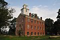
- The Ashland County Courthouse is a very important building in Ashland. It's where many local government decisions are made. It was added to the list in 1979.
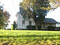
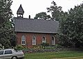
- The Anderson Schoolhouse is an old school building located southwest of Ashland. Imagine what it was like to go to school there many years ago! It became a historic place in 1977.
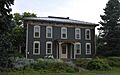
- In Loudonville, you can find the Philip J. Black House and the T.J. and Sarah Bull House. These homes show us what houses looked like in the past. The Black House was listed in 1980, and the Bull House in 2007.
- The City Hall and Opera House in Loudonville is another cool spot. It's a building that served as both a government office and a place for performances. It was added to the list in 1997.
- Hayesville has two interesting buildings: the Hayesville Opera House (listed in 1976) and the Vermilion Institute (listed in 1978). The Vermilion Institute was an important school in its time.
- The William Kelley Hardware Store-Hayesville Odd Fellows Hall in Hayesville was listed in 2017. This building shows how important local businesses and community groups were in the past.
- The Lakefork School, located southeast of Jeromesville, is another historic school building. It was listed in 1982.
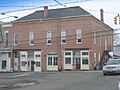
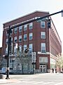
- In Ashland, the Myers Block-Home Company Building is a historic commercial building listed in 1997.
Historic Districts and Farms
Some listings are not just single buildings but entire areas or farms that are important.
- The Center Street Historic District in Ashland includes a whole section of Center Street. It's recognized for its collection of historic buildings. It was first listed in 1976, and its boundaries were expanded in 1993.
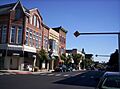
- The Downtown Ashland Historic District covers a larger area of downtown Ashland. It was added to the list in 2013, recognizing the historic importance of the city's main business area.
- The Crittenden Farm is located northwest of Savannah. This farm was listed in 1982, showing the importance of agriculture in the county's history.
- The John Crumrine Farm and the Michael Crumrine Farm, both north of Nova, were listed in 1990. These farms give us a glimpse into the agricultural heritage of the area.
- The John Garst House, northeast of Loudonville, is another historic farm property. It was listed in 1982.
Ancient Sites
Not all historic places are buildings! Some are much, much older.
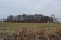
- The Sprott's Hill Mounds Site is a very old site with two mounds. These mounds were built by ancient people and are located on Sprott's Hill. This site was listed in 1976 and helps us learn about the earliest inhabitants of Ashland County.
Former Listings
Sometimes, a place might be removed from the National Register. This can happen if the building is destroyed or if it changes so much that it loses its historic importance.
- The Ashland County Jail in Ashland was listed in 1976 but removed in 1978.
- The First National Bank and Firestone Building, also in Ashland, was removed from the list in 1978.
These places, even if no longer on the list, are still part of Ashland County's rich history!
Images for kids
-
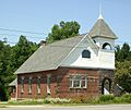
The historic Anderson Schoolhouse.
-
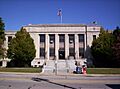
The Ashland County Courthouse.
-
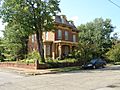
The Philip J. Black House in Loudonville.
-
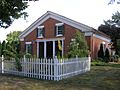
The T.J. and Sarah Bull House.
-
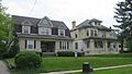
A view of the Center Street Historic District in Ashland.
-
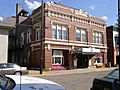
The City Hall and Opera House in Loudonville.
-
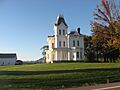
The Crittenden Farmhouse.
-
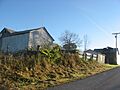
Barns at the John Crumrine Farm.
-
The Michael Crumrine Farmhouse.
-
A street view in the Downtown Ashland Historic District.
-
The John Garst House.
-
The Hayesville Opera House.
-
The Lakefork School.
-
The Myers Block-Home Company Building in Ashland.
-
The Sprott's Hill Mounds Site.
-
The Vermilion Institute.


