
National Register of Historic Places listings in Avoyelles Parish, Louisiana facts for kids

Have you ever wondered about the oldest and most important buildings and places in your community? In Avoyelles Parish, Louisiana, there's a special list of these historic spots! It's called the National Register of Historic Places. This list helps protect and celebrate places that are important to American history, architecture, archaeology, engineering, or culture.
Avoyelles Parish is a region in Louisiana, known for its rich history and unique culture. On this list, you'll find 30 amazing properties and districts. One of them is even a National Historic Landmark, which means it's super important to the entire country! A couple of other places were once on the list but have since been removed. Let's explore some of these cool historic sites!
Contents
Historic Buildings and Sites in Avoyelles Parish
Avoyelles Parish is home to many buildings and sites that tell stories from the past. These places are like windows into how people lived, worked, and built their communities long ago.
Homes and Plantations
Many historic homes in Avoyelles Parish are on the National Register. These houses show us different styles of architecture from the past.
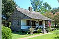
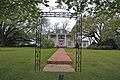
- Alfred H. Bordelon House and Hypolite Bordelon House: These homes in Marksville give us a peek into the lives of families from earlier times.
- Calliham Plantation House (Hamburg): This old plantation house shows what large farms and homes looked like in the past.
- Dr. Jules Charles Des Fosse House (Mansura): This house belonged to a doctor, giving us an idea of professional life in the community.
- Edwin Epps House (Bunkie): This house has a special story! It was moved and carefully put back together on the LSU-Alexandria Campus. It's a great example of how historic buildings can be saved.
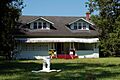
- Frithland (Bunkie): Another beautiful old home that helps us understand the history of the area.
- Joffrion House (Marksville): This house is also a part of the parish's architectural heritage.
- Thomas A. Lemoine House (Hamburg and Moreauville): Interestingly, there are two houses with this name, built in different years (1885 and 1916), showing how building styles changed over time.
- Lone Pine (Evergreen): This property adds to the collection of historic homes in the parish.
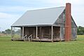
- Oak Hall (Bunkie) and Oakwold Plantation House (Evergreen): These grand old homes remind us of the plantation era in Louisiana.
- Dr. Thomas A. Roy, Sr., House (Mansura): Another doctor's home, showing the importance of medical professionals in the community's history.
Community Buildings and Churches
Beyond homes, many public and religious buildings are also recognized for their historical value.
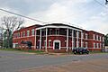
- Bailey Hotel (Bunkie): Imagine staying in this hotel many years ago! It's a reminder of how people traveled and where they stayed.
- Bailey Theatre (Bunkie): This old theater was once a place for entertainment and community gatherings.
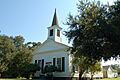
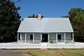
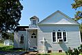
- Bayou Rouge Baptist Church (Evergreen): Churches are often central to a community's history and spiritual life.
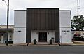
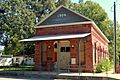
- Central Bank and Trust Co. (Hessmer) and Central Bank and Trust Company, Mansura: These old bank buildings show us where people handled their money and business. The Mansura bank is now a Senior Citizens Center!
- Louisiana Railway and Navigation Company Depot (Mansura): Train depots were once very busy places, connecting towns and helping people and goods move around.
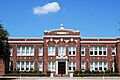
- Moreauville High School (Moreauville): This old school building holds memories of many students and teachers.
- Adam Ponthieu Store-Big Bend Post Office (Big Bend): This building served as both a store and a post office, showing how important these services were to small communities.
- St. Mary's Assumption Church (Cottonport) and St. Paul Lutheran Church (Mansura): These churches are important religious landmarks in their towns.
Important Historic Districts and Sites
Some places are important not just for one building, but for a whole area or for their ancient history.
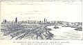
- Marksville Commercial Historic District (Marksville): This district includes a whole area of historic buildings in Marksville, showing what the town's main business area looked like long ago.
- Marksville Prehistoric Indian Site (Marksville): This is a very special place! It's a National Historic Landmark because it's an ancient site where Native American people lived thousands of years ago. It's now a state park where you can learn about their history.
Engineering and Military History
Some listings highlight important engineering feats or military history.
- Bordelonville Floodgate (Bordelonville): This floodgate is an important part of how people managed water and protected their land from floods.
- Fort DeRussy (Marksville): This fort played a role in the American Civil War. It's a place where you can learn about military history.
- Fort No. 2 at Yellow Bayou (Simmesport): Another site from the Civil War, showing where battles and defenses were located.
- Sarto Bridge (Big Bend): Bridges are important for connecting communities, and this one is recognized for its historical design.
- Texas and Pacific Railroad Depot (Bunkie): Like the Mansura depot, this railroad station was a key part of transportation and trade.
Places That Were Once Listed
Sometimes, a historic place might be removed from the National Register. This can happen for different reasons, like if the building is destroyed or moved, or if it changes too much.
- Clarendon Plantation House (Evergreen): This plantation house was on the list but was removed in 2016.
- Lacour's Fish and Ice Company Building (Simmesport): This building, important for its role in the local fishing industry, was removed from the list in 2015.
These places, even if they are no longer on the official list, still have stories to tell about the history of Avoyelles Parish!
Images for kids
-
The historic Bailey Hotel in Bunkie.
-
The old Bailey Theatre, once a center for entertainment.
-
Bayou Rouge Baptist Church in Evergreen.
-
The Hypolite Bordelon House.
-
The Central Bank and Trust Company building in Mansura, now a Senior Citizens Center.
-
The Dr. Jules Charles Des Fosse House.
-
The Edwin Epps House, which was moved and restored.
-
Fort DeRussy, a Civil War site.
-
Frithland, a historic home in Bunkie.
-
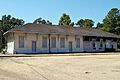
The Louisiana Railway and Navigation Company Depot in Mansura.
-
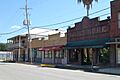
A view of the Marksville Commercial Historic District.
-
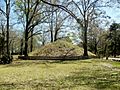
A burial mound at the Marksville Prehistoric Indian Site.
-
Moreauville High School.
-
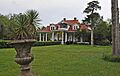
Oak Hall, a historic plantation house.
-
The Dr. Thomas A. Roy, Sr., House in Mansura.
-
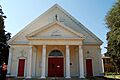
St. Mary's Assumption Church in Cottonport.
-
St. Paul Lutheran Church near Mansura.
-

The Texas and Pacific Railroad Depot in Bunkie.


