
National Register of Historic Places listings in Bamberg County, South Carolina facts for kids

Welcome to Bamberg County, South Carolina! This page is all about the amazing places here that are listed on the National Register of Historic Places. Think of this register as a special list of buildings, areas, or sites that are super important to the history of the United States. They are protected and celebrated because they tell us stories about the past.
In Bamberg County, there are 12 different places on this list. One of them is even more special: it's a National Historic Landmark, which means it's considered one of the most important historic places in the entire country!
Contents
Discovering Bamberg County's Historic Treasures
This section will introduce you to some of the cool historic spots in Bamberg County. These places help us understand what life was like long ago and how our communities grew.
Buildings with a Story
Many of the places on the National Register are buildings that have stood for a long time and seen many changes.
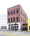
- American Telephone and Telegraph Company Building: Located in Denmark, this building was added to the list in 1999. It played a part in how people communicated in the past.
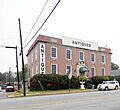
- Bamberg City Hall: This important building in Bamberg, listed in 2005, is where local government decisions are made. It's a key part of the town's daily life.
- Bamberg Post Office: Also in Bamberg, this post office was recognized in 2007. Imagine all the letters and packages that have passed through its doors over the years!
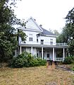
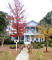
- Gen. Francis Marion Bamberg House: This house, listed in 1976, belonged to General Francis Marion Bamberg. He was an important person in the history of the area.
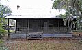
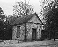
- Copeland House: Found near Ehrhardt, this house was added to the list in 1991. It's a great example of older homes in the region.
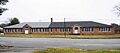
- Denmark High School: This school in Denmark, listed in 2001, has educated many students over the years. It's a place where history was made every day for generations of young people.
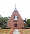
- Mizpah Methodist Church: Near Olar, this church was listed in 2000. Churches often serve as important community centers and places of worship for many years.
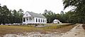
- Woodlands: This historic site, located south of Bamberg, became a National Historic Landmark in 1971. This means it's one of the most important historical places in the whole country!
Historic Districts and Special Sites
Sometimes, it's not just one building but a whole area that is historically important.
- Bamberg Historic District: This district in Bamberg, listed in 1983, includes several streets and buildings. Walking through it is like taking a step back in time!
- Cal Smoak Site: This site, listed in 1986, has a restricted address, meaning its exact location is kept private to protect it. It's likely an archaeological site, holding clues about ancient times.
- Rivers Bridge State Park: Located near Ehrhardt, this park was added to the list in 1972. It's a significant historical site, especially known for events from the American Civil War.
- Voorhees College Historic District: The campus of Voorhees College in Denmark was recognized as a historic district in 1982. This college has a rich history of providing education and opportunity.
Images for kids
-
The American Telephone and Telegraph Company Building in Denmark.
-
Bamberg City Hall, an important building for the town.
-
A view of the Bamberg Historic District.
-
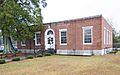
The Bamberg Post Office.
-
The historic home of General Francis Marion Bamberg.
-
The Copeland House near Ehrhardt.
-
Denmark High School.
-
Mizpah Methodist Church.
-
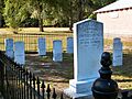
A view from Rivers Bridge State Park.
-
The Voorhees College campus.
-
Woodlands, a National Historic Landmark.


.jpg)
