
National Register of Historic Places listings in Banks County, Georgia facts for kids
Did you know that some buildings and places are so special that they are officially recognized as important parts of history? In Banks County, Georgia, there are many such places! They are listed on something called the National Register of Historic Places (NRHP). This is like a special list kept by the United States government to help protect and celebrate buildings, sites, and objects that are important to American history, architecture, archaeology, engineering, or culture. When a place is on this list, it means it's a treasure that tells a story about the past.
Historic Places in Banks County
Here are some of the amazing historic places and areas in Banks County, Georgia that are listed on the National Register of Historic Places. Each one has a unique story!
| Name on the Register | Image | Date listed | Location | City or town | Description | |
|---|---|---|---|---|---|---|
| 1 | Banks County Courthouse |
.jpg) |
(#80000969) |
Off U.S. 441 34°20′05″N 83°29′56″W / 34.334722°N 83.498889°W |
Homer | This historic courthouse in Homer was once the main building for local government. |
| 2 | Banks County Jail |
 |
(#82002382) |
Silver Shoals Rd. 34°20′06″N 83°29′20″W / 34.335°N 83.488889°W |
Homer | The old jail building in Homer tells a story about law and order in the past. |
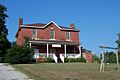
| 3 | Brooks Family Farm |
 |
(#13000529) |
584 Silver Shoals Rd. 34°22′14″N 83°33′14″W / 34.3706558°N 83.5538831°W |
Lula | This farm shows how families lived and worked in the area long ago. |
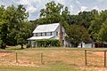
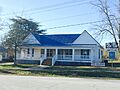
| 4 | William Chambers House |
.JPG) |
(#96001305) |
GA 51, approximately 1 mi. W of jct. with GA 63 34°22′15″N 83°25′13″W / 34.370833°N 83.420278°W |
Homer | A historic home that gives us a peek into the past. |
| 5 | Fort Hollingsworth-White House |
.JPG) |
(#19980806) |
Wynn Lake Rd., 2 mi. SE of Hollingsworth 34°25′35″N 83°32′02″W / 34.426389°N 83.533889°W |
Hollingsworth | This old house and fort date back to the late 1700s, showing early settlement. |
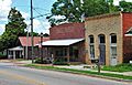
| 6 | Gillsville Historic District |
 |
(#85001933) |
GA 52 34°18′38″N 83°38′20″W / 34.310556°N 83.638889°W |
Gillsville | A historic district means a whole area with many old buildings that are important together. |
| 7 | Hebron Church, Cemetery, and Academy |
.JPG) |
(#85002176) |
Hebron Circle 34°17′12″N 83°21′53″W / 34.286667°N 83.364722°W |
Commerce | This site includes an old church, a cemetery, and where an academy once stood, showing community life. |
| 8 | Homer Historic District |
.JPG) |
(#85003110) |
Along Main St. and Silver Shoals Rd. 34°19′59″N 83°29′52″W / 34.333056°N 83.497778°W |
Homer | Another historic district, this one in Homer, preserves the look and feel of the town's past. |
| 9 | Kesler Covered Bridge |
(#75000571) |
10 mi. N of Homer on County Line Rd. over Middle Fork Broad River 34°25′27″N 83°23′16″W / 34.424167°N 83.387778°W |
Homer | A historic covered bridge, a type of bridge that was common long ago. | |
| 10 | Maysville Historic District |
 |
(#85002203) |
Along E. Main, W. Main and Homer Sts. 34°15′17″N 83°33′48″W / 34.254722°N 83.563333°W |
Maysville | This district in Maysville helps keep the town's historical character alive. |
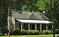
| 11 | Mount Pleasant Historic District |
.JPG) |
(#96001306) |
Jct. of GA 51 and Damascus Road 34°21′53″N 83°26′33″W / 34.3646°N 83.4426°W |
Homer | Another important historic area in Homer, showing how communities grew. |
| 12 | Nails Creek Historic District |
 |
(#96001307) |
Jct. of GA 51 and GA 63 34°22′00″N 83°24′02″W / 34.366667°N 83.400556°W |
Homer | This district around Nails Creek has buildings that show the history of the area. |
| 13 | New Salem Covered Bridge |
(#75000570) |
6 mi. N of Commerce on SR S992 over Grove Creek 34°15′30″N 83°25′20″W / 34.258333°N 83.422222°W |
Commerce | Another example of a historic covered bridge in Banks County. | |
| 14 | Turk Family Farm |
(#03001365) |
534 Carson Segars Rd. 34°17′37″N 83°32′43″W / 34.293611°N 83.545278°W |
Maysville | This farm is recognized for its historical importance to the area. |
Images for kids
-
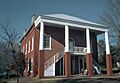
The historic Banks County Courthouse.
-
The old Banks County Jail building.
-
The Brooks Family Farm, a historic agricultural site.
-
The William Chambers House, built around 1906.
-
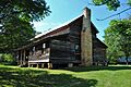
The Fort Hollingsworth-White House, dating back to 1793.
-
A historic home in the Gillsville Historic District.
-
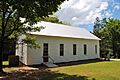
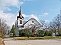
Mount Hebron Presbyterian Church, part of a historic complex.
-
A view of the Homer Historic District.
-
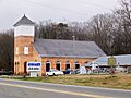
An old church in the Maysville Historic District.
-
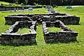
The cemetery at Mount Pleasant Methodist Church.
-
Nails Creek Baptist Church, located in its historic district.
