
National Register of Historic Places listings in Bath County, Kentucky facts for kids

Have you ever wondered about the special places in your community that tell a story from the past? In Bath County, Kentucky, there are nine amazing spots that are so important, they've been added to the National Register of Historic Places. This is like a special list kept by the United States government. It helps protect buildings, sites, and objects that are important in American history, architecture, archaeology, engineering, or culture.
When a place is on this list, it means it's a treasure that should be preserved for future generations, including you! Let's explore some of these cool historic places in Bath County.
Contents
Historic Places in Bath County
Bourbon Iron Works

The Bourbon Iron Works is an old factory located south of Owingsville, Kentucky. It was added to the National Register of Historic Places on September 1, 1976. This site was once a busy place where iron was made. Imagine the sounds of machines and workers creating metal products long ago! It's a reminder of how important industries like iron making were in Kentucky's past.
Confederate Monument in Owingsville

East of Owingsville, you can find the Confederate Monument in Owingsville. This monument was placed on the National Register on July 17, 1997. Monuments like this are built to remember important events or people from history. This one specifically honors those who fought in the American Civil War from the Confederate side. It stands as a historical marker in the community.
Myrtle Hill
Myrtle Hill is a historic property located south of Owingsville. It was added to the National Register of Historic Places on October 29, 1982. While we don't have a picture of it here, places like Myrtle Hill often represent important homes or estates from the past. They show us how people lived and what kind of architecture was popular many years ago.
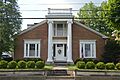
J.J. Nesbitt House

The J.J. Nesbitt House is a beautiful home located at 233 West Main Street in Owingsville. It became a registered historic place on August 5, 2010. Old houses like this one are often preserved because of their unique design or because important people once lived there. They give us a glimpse into the daily lives of people from different eras.
Col. Thomas Deye Owings House

Right in the heart of Owingsville, at Main Street and Courthouse Square, stands the Col. Thomas Deye Owings House. This house was listed on the National Register on January 9, 1978. Colonel Thomas Deye Owings was a very important person in the history of Owingsville, as he helped found the town. His home is a key part of the town's heritage.
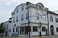
Owingsville Commercial District and Courthouse Square

The Owingsville Commercial District and Courthouse Square is a whole area in Owingsville that is considered historic. It includes Main and Court Streets and was added to the National Register on November 20, 1978. This means that many of the buildings in this part of town are old and important. They show what a busy town center looked like in the past, with shops, businesses, and the courthouse where important decisions were made.
Ramey Mound
The Ramey Mound is an archaeological site located north of Sharpsburg, Kentucky. It was added to the National Register on February 12, 1998. Mounds like this were often built by ancient Native American cultures. They can be burial sites or places used for ceremonies. Studying them helps archaeologists learn about the people who lived in Kentucky thousands of years ago.
"Raccoon" John Smith House

Another historic home in Owingsville is the "Raccoon" John Smith House, located at 250 West Main Street. It was listed on the National Register on August 6, 2012. "Raccoon" John Smith was a famous religious leader in Kentucky during the 1800s. His home is important because it connects us to his life and the history of religious movements in the state.
Springfield Presbyterian Church
The Springfield Presbyterian Church is a historic church located south of Sharpsburg on Springfield Road. It was added to the National Register on April 26, 1979. Churches are often important historical sites because they served as centers for community life, worship, and social gatherings for many years. This church tells a story about the religious and community history of the Sharpsburg area.
These nine places in Bath County are like windows into the past. They help us understand the history, people, and events that shaped this part of Kentucky. Visiting them can be a great way to learn about your local heritage!
Images for kids
-
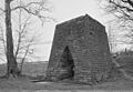
The historic Bourbon Iron Works building.
-
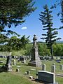
The Confederate Monument in Owingsville.
-
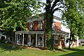
The J.J. Nesbitt House in Owingsville.
-
The Col. Thomas Deye Owings House.
-
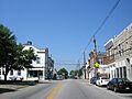
Downtown Owingsville, showing part of the historic Commercial District.
-
The "Raccoon" John Smith House.
