
National Register of Historic Places listings in Bertie County, North Carolina facts for kids

Bertie County, North Carolina, is home to many special places that tell stories about the past. These places are so important that they are listed on the National Register of Historic Places. This is like a national honor roll for buildings, sites, and objects that have played a big role in American history, architecture, archaeology, engineering, or culture. When a place is on this list, it means it's recognized for its historical value and efforts are made to protect it.
This article will introduce you to some of these amazing historic spots in Bertie County. Each one helps us understand what life was like long ago and how our communities grew.
Discovering Bertie County's Historic Places
Bertie County has many buildings and areas that are recognized for their historical importance. These sites include old homes, public buildings, and even entire neighborhoods. They help us learn about the people and events that shaped this part of North Carolina.
Important Homes and Plantations
Many of the historic places in Bertie County are old homes and plantations. These buildings often show us how people lived, worked, and built their communities centuries ago.
Hope Plantation
One of the most famous historic sites is Hope Plantation. It's located near Windsor and was built in 1803. This plantation was once owned by David Stone, who was a governor of North Carolina and a U.S. Senator. Hope Plantation is a great example of early American architecture and gives us a peek into the past. It shows how large farms operated and how people lived in the early 1800s.
King House
Another interesting home is the King House, also near Windsor. This house was built even earlier, around 1763. It's a wonderful example of colonial-era architecture. Visiting places like the King House helps us imagine what life was like before the United States was even fully formed.
Other Notable Homes
- Ashland: This historic home is located near Ashland. It was added to the list in 2003.
- Elmwood: There are actually two historic homes named Elmwood in Bertie County. One is near Merry Hill and the other near Windsor. Both are important examples of older homes in the area.
- The Hermitage: Found north of Merry Hill, this property was recognized in 1982.
- Jordan House: Located south of Windsor, this house was added to the list in 1971.
- King-Freeman-Speight House: This home is west of Republican and was listed in 1982.
- William H. Lee House: In Lewiston, this house was added more recently in 2012.
- Liberty Hall: This historic site is off SR 1108 near Windsor and was listed in 1982.
- Oaklana: Northeast of Roxobel, this property was added in 1982.
- Pineview: Also near Roxobel, Pineview was listed in 1982.
- Rosefield: Located in Windsor, Rosefield was recognized in 1982.
- Scotch Hall: East of Merry Hill, Scotch Hall was added to the list in 1982.
- Woodbourne: West of Roxobel, Woodbourne was listed in 1971.
Important Public Buildings and Districts
Besides private homes, some public buildings and even whole sections of towns in Bertie County are historically significant.
Bertie County Courthouse
The Bertie County Courthouse in Windsor is a very important building. It's where many local government decisions have been made for a long time. It was added to the National Register in 1979. Courthouses often have unique architecture and represent the center of a community's legal and civic life.
Bertie Memorial Hospital
The Bertie Memorial Hospital in Windsor is another significant building. It was listed in 2004. Hospitals are important because they show the history of healthcare and community services in an area.
St. Frances Methodist Church
Churches also play a big role in a community's history. The St. Frances Methodist Church near Lewiston was added to the list in 1982. Churches are often centers of social life and important landmarks.
Freeman Hotel
The Freeman Hotel in Windsor was listed in 1982. Hotels are interesting because they show how people traveled and stayed in towns in the past.
Historic Districts
Sometimes, not just one building but a whole area is considered historic. This is called a "historic district."
- Windsor Historic District: This district includes many important buildings in the heart of Windsor. It was recognized in 1991.
- Woodville Historic District: Similarly, a section of Lewiston Woodville is recognized as a historic district. It was added in 1998.
Other Unique Sites
- Garrett-White House: This house is located west of Colerain and was listed in 1982.
- Rhodes Site: This site near Hamilton is a special case because its exact location is kept private to protect it. It was listed in 1986. Archaeological sites like this can hold clues about very old human settlements.
These historic places in Bertie County are like open books, each telling a part of North Carolina's rich history. They remind us of the people who lived here before us and the legacies they left behind.
Images for kids
-
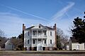
The front of Hope Plantation, built in 1803.
-
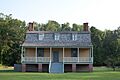
The exterior of the King House, dating back to 1763.
-

This image indicates that the address for the Rhodes Site is restricted to protect its historical value.


