
National Register of Historic Places listings in Bon Homme County, South Dakota facts for kids

This page is about special places in Bon Homme County, South Dakota that are listed on the National Register of Historic Places. This list helps protect important buildings, sites, and objects that tell us about the past.
The National Register of Historic Places is like a special club for buildings and places that are important to American history. When a place is added to this list, it means it has a unique story to tell. It could be an old house, a school, a bridge, or even a whole neighborhood!
In Bon Homme County, there are 40 different places on this list. Each one helps us understand what life was like long ago in South Dakota.
What is the National Register of Historic Places?
The National Register of Historic Places is the official list of the nation's historic places. It is part of a program run by the United States government. This program helps to save and celebrate places that are important to history.
Why are places listed?
Places are listed for many reasons. They might be important because of their:
- History: A famous event happened there, or an important person lived there.
- Architecture: The building has a special design or was built in a unique way.
- Culture: The place shows how people lived, worked, or played in the past.
- Archaeology: It contains important clues about ancient civilizations.
When a place is on the National Register, it gets special recognition. It can also get help for its preservation. This means people work to keep it safe and in good condition for future generations.
Historic Places in Bon Homme County
Bon Homme County has many interesting places on the National Register. These sites show the rich history of the area. They include old courthouses, schools, churches, and even unique farm buildings.
Important Public Buildings
Many public buildings in the county are listed because they played a big role in community life.
Bon Homme County Courthouse
The Bon Homme County Courthouse in Tyndall is one such building. It was built in 1984. Courthouses are often important centers for local government and community events.

Carnegie Public Library of Tyndall
Another important building is the Carnegie Public Library of Tyndall. This library was built with money from Andrew Carnegie. He was a rich businessman who helped build many libraries across the United States. Libraries like this one were vital for education and learning in the past.

Main Hall in Springfield
The Main Hall is on the former campus of the University of South Dakota - Springfield. This building was once a key part of a university. It helped educate many people in the region.
Unique Homes and Farmsteads
Many homes and farms in Bon Homme County are also on the list. They show how people lived and built things long ago.
Chalkrock Houses
You'll find several "chalkrock" houses listed. These are homes built using a special type of soft rock found in the area. Examples include the John Hakl Chalkrock House and the Joseph Herman Chalkrock House near Tabor. These houses show how early settlers used local materials to build their homes.
Historic Farmsteads
Farmsteads like the Cihak Farmstead and the John Frydrych Farmstead are also recognized. These places often include old barns, stables, and other farm buildings. They tell us about the history of farming in South Dakota.

The Koobs House
The Koobs House in Scotland is another example of a historic home. It was built in 1984. Old houses like this often have special architectural details or stories about the families who lived there.
_from_W_1.JPG)
Churches and Community Centers
Churches and community halls are important parts of any town's history. They were places where people gathered for worship, meetings, and social events.
Methodist Episcopal Church
The Methodist Episcopal Church in Scotland is a historic church. It was built in 1979. Churches often have beautiful designs and hold many memories for the community.

St. Wenceslaus Catholic Church
In Tabor, the St. Wenceslaus Catholic Church and Parish House is a very important site. It includes both the church and the parish house. These buildings are central to the history of the Czech community in Tabor.
_from_SE_1.JPG)
ZCBJ Hall
The ZCBJ Hall in Tyndall is a community hall. It was built in 1985. Halls like this were often used for dances, plays, and other social gatherings. They were very important for community life.

Historic Districts
Sometimes, not just one building, but a whole area is considered historic. These are called historic districts.
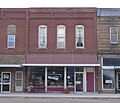
Scotland Main Street Historic District
The Scotland Main Street Historic District includes many buildings along Main Street in Scotland. This district shows what a busy main street looked like in the past. It helps us imagine how people shopped and worked there.

Scotland Residential Historic District
The Scotland Residential Historic District is another important area in Scotland. This district includes many historic homes. Walking through it is like taking a step back in time to see how people lived in the past.

Historic Bridges
Even bridges can be historic! They are important because they show how people built things and how transportation has changed over time.
South Dakota Dept. of Transportation Bridges
Several bridges in Bon Homme County are on the list. For example, South Dakota Dept. of Transportation Bridge No. 05-028-200 over Choteau Creek. These bridges are recognized for their engineering or their role in connecting communities.


Images for kids
-
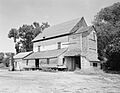
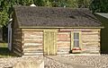
Bon Homme Hutterite Colony
-
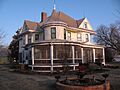
Dr. John C. Greenfield House
-
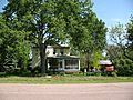
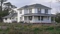
Peter and Minnie Monfore House
-
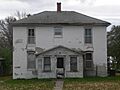
Old St. Wenceslaus Catholic Parish House
-
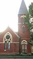
St. Andrew's Episcopal Church
-
Tabor School
-
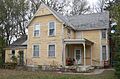
Thompson House
-
Joseph V. Wagner House
-
William Metzgers New Emporium
.jpg)


_from_N_1.JPG)

_from_WNW_1.JPG)
_from_SE_1.JPG)
_from_S_1.JPG)

