
National Register of Historic Places listings in Bremer County, Iowa facts for kids

Have you ever wondered about old buildings and places that have a special story? In Bremer County, Iowa, there are several amazing spots that are so important, they're listed on something called the National Register of Historic Places. This special list helps protect buildings, sites, and objects that are important to American history, architecture, archaeology, engineering, or culture. When a place is on this list, it means it's recognized for its unique past and is worth preserving for future generations to enjoy and learn from.
There are 11 different places and areas in Bremer County that are on this special list. Each one tells a part of the county's history!
Contents
Discovering Bremer County's Historic Treasures
The National Register of Historic Places is the official list of the United States' historic places worthy of preservation. It's like a hall of fame for buildings and sites that have played a big role in history. Let's explore some of the cool places in Bremer County that have earned a spot on this list.
Important Buildings in Bremer County
Many buildings in Bremer County have been recognized for their historical importance. These structures often show us how people lived, worked, and built things in the past.
The Bremer County Court House
The Bremer County Court House in Waverly, Iowa is a very important building. It's where many local government decisions are made and where official records are kept. This courthouse was added to the National Register on August 28, 2003. It stands as a symbol of justice and community in Bremer County.
The Bank of Sumner
Located at 118 West 1st Street in Sumner, Iowa, the Bank of Sumner is another historic building. It was listed on the National Register on August 25, 2004. Banks are often important parts of a town's history, showing how local businesses and the economy grew over time. This building likely has many stories about the financial life of Sumner.
Wartburg Teachers' Seminary (Old Main)
On the campus of Wartburg College in Waverly, Iowa, you'll find a building known as Old Main. This building was once the Wartburg Teachers' Seminary. It was added to the National Register on January 20, 1978. It's a key part of the college's history and shows how education developed in the area.
Sumner High School
The old Sumner High School building, located at 300 West 4th Street in Sumner, Iowa, is also on the list. It was recognized on June 16, 2004. School buildings often hold many memories for a community, representing generations of students and teachers.
Historic Districts and Areas
Sometimes, it's not just one building that's historic, but a whole group of buildings or a specific area. These are called "historic districts." They show how a neighborhood or a business area developed over time.
Waverly East Bremer Avenue Commercial Historic District
The Waverly East Bremer Avenue Commercial Historic District includes a section of East Bremer Avenue in Waverly, Iowa. This area was added to the National Register on April 24, 2014. It's important because it shows what a busy main street looked like in the past, with many old shops and businesses. Exploring this district is like taking a step back in time to see how people shopped and worked.
Other Waverly Historic Districts
Waverly has a few other historic districts that are recognized:
- The Harmon and LeValley Northwest Historic District was listed on June 6, 2014.
- The Old Fourth Ward Southeast Historic District was listed on December 18, 2013.
- The Sturdevant Southwest Historic District was listed on May 16, 2016.
These districts help preserve the unique character and history of different neighborhoods in Waverly.
Unique Historic Structures
Beyond buildings and districts, some unique structures are also recognized for their historical significance.
Green Mill Ford Bridge
The Green Mill Ford Bridge crosses the Cedar River near Janesville, Iowa. This bridge was added to the National Register on June 25, 1998. Old bridges are important because they show us how engineers built structures to help people travel and connect communities in the past.
Waverly Municipal Hydroelectric Powerhouse
The Waverly Municipal Hydroelectric Powerhouse is located at 121 1st Street, NE, in Waverly, Iowa. It was listed on December 18, 2013. This powerhouse is a great example of early technology used to create electricity from water power. It played a big role in bringing power to the town.
Waverly House
The Waverly House at 402 West Bremer Avenue in Waverly, Iowa was added to the National Register on December 12, 1976. Historic houses often tell us about the families who lived there and the architectural styles popular during different periods.
Images for kids
-
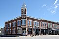
The historic Bank of Sumner building.
-
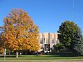
The Bremer County Court House in Waverly.
-
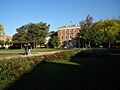
Old Main at Wartburg College.
-
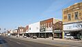
A view of East Bremer Avenue in Waverly.


