
National Register of Historic Places listings in Bullitt County, Kentucky facts for kids

This article is about special places in Bullitt County, Kentucky, that are listed on the National Register of Historic Places. This list helps protect important buildings, sites, and objects that tell us about the past. These places are like treasures that show us how people lived long ago in Kentucky.
You can find 10 different places and areas in Bullitt County that are on this important list.
Contents
What is the National Register of Historic Places?
The National Register of Historic Places is an official list kept by the United States government. It includes buildings, sites, objects, and districts that are important in American history, architecture, archaeology, engineering, or culture. When a place is added to this list, it means it's recognized as special and worth preserving for future generations. It's like giving a medal to a building or a piece of land because it has a great story to tell!
Historic Places in Bullitt County
Bullitt County has many interesting places that are part of the National Register. These sites help us learn about the history of the area, from ancient times to more recent years.
Ashworth Rock Shelters Site
This site is located near Shepherdsville, Kentucky, at the foot of McDonald's Knob. It includes ancient rock shelters along Floyds Fork. These shelters were likely used by early people living in the area many, many years ago. It was added to the list in 1975.
Bank of the Commonwealth
Found on Buckman Street in Shepherdsville, Kentucky, this building is a historic bank. It shows us what banks looked like and how they operated a long time ago. It became a historic place in 1987.

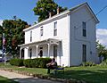
Henry J. Barnes House
This house is at 144 North Bardstown Road in Mount Washington, Kentucky. It's an old home that gives us a peek into the past lives of people in the community. It was added to the list in 1993.

T. Jeremiah Beam House
Located on Big Level Road in Clermont, Kentucky, this house has historical importance. It is connected to the Beam family, who are famous for their distilling history in Kentucky. This house was recognized in 1987.
Solomon Neill Brooks House
This historic house is northeast of Shepherdsville, Kentucky, at Hebron Lane and Kentucky Route 61. It's another example of the old homes that tell the story of early settlers and families in Bullitt County. It joined the list in 1980.
Henry Crist House
You can find the Henry Crist House on Maraman Lane, off Kentucky Route 1604, near Brownington, Kentucky. This house is named after Henry Crist, an important person in Kentucky's early history. It was listed in 1987.
Lebanon Junction Historic District
This is not just one building, but a whole area in Lebanon Junction, Kentucky! It includes many historic buildings roughly bounded by Maple Street, Kentucky Route 61, Knoxville Avenue, and Harrel and Masden Streets. A historic district means that many buildings in that area are important together. This district was added in 2003.
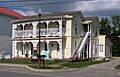
James M. Lloyd House
The James M. Lloyd House is in Mount Washington, Kentucky, at the corner of U.S. Route 31E and East Street. This house is another example of the beautiful and historic homes in the county. It was listed in 1993.

Zack Stansbury House
This house is located at 1430 Bardstown Road in Mount Washington, Kentucky. Like other historic homes, it helps us understand the architectural styles and daily life from a different time. It was added to the list in 1993.

Images for kids
-
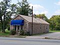
The historic Bank of the Commonwealth building.
-
A view of the Henry J. Barnes House.
-
The James M. Lloyd House.
-
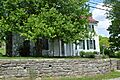
The Zack Stansbury House.
