
National Register of Historic Places listings in Calhoun County, South Carolina facts for kids

Imagine a special list that helps protect important old buildings, places, and sites across the United States! This list is called the National Register of Historic Places. When a place is added to this list, it means it's really important to the history, architecture, or culture of our country. It helps make sure these places are preserved for future generations to learn from and enjoy.
In Calhoun County, South Carolina, there are 17 amazing places on this list. These sites tell us stories about the past, from ancient Native American villages to grand old homes and important battlefields. Let's explore some of these fascinating historical treasures!
Discovering Calhoun County's Historic Treasures
Calhoun County is home to many places that have played a big part in history. These sites help us understand what life was like long ago and how the area grew over time.
Historic Homes and Plantations
Many of the places on the National Register in Calhoun County are old houses and plantations. These buildings show us how people lived, worked, and built their communities centuries ago.
Grand Old Houses
Several beautiful old homes are on the list. For example, the Col. J.A. Banks House in St. Matthews is a wonderful example of architecture from its time. Another is the Col. Olin M. Dantzler House, also in St. Matthews, which has a unique design. These homes often belonged to important families in the county's history. The David Houser House and the Haigler House are other examples of historic homes that have been preserved.
Plantation Life
Plantations were large farms that were very common in the South. Several plantations in Calhoun County are on the list, giving us a glimpse into this part of history. Midway Plantation and Oakland Plantation, both near Fort Motte, are examples of these large estates. They show the style of living and farming that was common in the past. Lang Syne Plantation and Zante Plantation also offer insights into the agricultural history of the region.
Important Historical Sites
Beyond homes, Calhoun County has sites that mark major historical events or ancient human activity.
Ancient Discoveries
Some of the oldest sites on the list are related to Native American history. The Buyck's Bluff Archeological Site and the Prehistoric Indian Village are places where scientists can learn about the lives of people who lived in this area thousands of years ago. These sites help us understand early cultures and how they interacted with the land.
Battlefields and Paths
History also includes important events like battles and old travel routes. The Fort Motte Battle Site is a significant location from the American Revolutionary War. It reminds us of the struggles for independence. The Cherokee Path is another historic site, showing an old trail used by Native Americans and early settlers. These places tell stories of conflict, travel, and the development of the region.
Community Buildings
Public buildings also hold important historical value, showing how communities were organized and served their people.
Places for Everyone
The Calhoun County Courthouse in St. Matthews is an important building where local government decisions are made. It has been a central part of the community for many years. The Calhoun County Library, also in St. Matthews, is another historic public building. Libraries are places for learning and community gathering, and this one has served the people of Calhoun County for a long time.
Images for kids
-

This image represents sites where the exact location is kept private for protection.
-
The Calhoun County Courthouse, a key building for local government.
-

The Calhoun County Library, a historic place for learning and community.
-

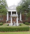
The historic Col. Olin M. Dantzler House in St. Matthews.
-
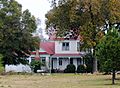
The Haigler House, an example of a historic home in Cameron.
-

The David Houser House, a preserved historic residence.
-

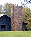
Midway Plantation, a historic estate near Fort Motte.
-

Oakland Plantation, another significant historical plantation.
-
Puritan Farm, a historic property west of St. Matthews.
-

The Ulmer-Summers House, a historic home in Cameron.


