
National Register of Historic Places listings in Carbon County, Wyoming facts for kids

Welcome to Carbon County, Wyoming! This area is full of amazing places that tell stories about the past. Many of these special spots are listed on the National Register of Historic Places. This is a list of important buildings, sites, and areas in Carbon County that are protected because of their history.
These places help us learn about how people lived long ago, from ancient times to more recent history. There are 49 such places in Carbon County. One of them is even a National Historic Landmark, which means it's super important to the whole country!
Contents
What is the National Register of Historic Places?
The National Register of Historic Places (often called NRHP) is the official list of places in the United States that are worth saving. These places can be buildings, structures, objects, sites, or even entire historic districts. They are chosen because they have special meaning in American history, architecture, archaeology, engineering, or culture.
When a place is added to the National Register, it means it's recognized for its importance. This helps protect it and makes people more aware of its value. It's like giving a medal to a place for being a historical superstar!
Exploring Carbon County's Historic Treasures
Carbon County is home to many fascinating historic sites. Let's explore some of them and discover the stories they hold.
Old Forts and Important Crossings
Long ago, these areas were vital for travel and defense.
- Fort Steele: This old fort is located on the North Platte River. It was an important military post during the late 1800s, helping to protect the Union Pacific Railroad as it was being built across the country. It's a great place to imagine what life was like for soldiers back then.
- Fort Halleck: Southwest of Elk Mountain, this was another military fort. It played a role in protecting travelers and telegraph lines during the early days of settlement in Wyoming.
- Bridger's Pass: This natural pass southwest of Rawlins was a key route for pioneers and explorers. It was named after the famous mountain man Jim Bridger. Imagine all the wagons and people who passed through here on their way west!
Cool Buildings and Town History
Many buildings in Carbon County show us how towns grew and changed.
- Elk Mountain Hotel: Found in the town of Elk Mountain, this historic hotel was a popular stop for travelers. It still stands as a reminder of the early days of hospitality in the West.
- George Ferris Mansion: In Rawlins, this grand house belonged to George Ferris. It shows the fancy architecture and lifestyle of important people from the past.
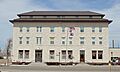
- First State Bank of Baggs: This building in Baggs tells the story of early businesses and how towns developed. Banks were crucial for communities to grow.
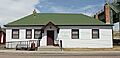
- Hanna Community Hall: Located in Hanna, this hall was a central gathering place for the community. It hosted events and meetings, bringing people together.
- Medicine Bow Union Pacific Depot: In Medicine Bow, this train station was a busy hub. It connected the town to the rest of the country through the Union Pacific Railroad.
- Virginian Hotel: Also in Medicine Bow, this hotel is famous for its connection to the novel The Virginian. It's a landmark that brings to life the spirit of the Old West.
- Union Pacific Railroad Depot (Rawlins): This depot in Rawlins was another vital train station. It shows the importance of railroads in connecting towns and transporting goods and people.
- Wyoming State Penitentiary District: In Rawlins, this historic prison complex tells a unique story about law and order in Wyoming's past. Its old stone walls have many tales to tell.
- Downtown Rawlins Historic District: This area in Rawlins includes many historic buildings. Walking through it is like stepping back in time to see how the town looked long ago.
- Parco Historic District: In Sinclair, this district shows a planned community. It was built around an oil refinery and has a unique architectural style.
Nature's Wonders and Ancient Sites
Some historic places are natural formations or sites where ancient people lived.
- Como Bluff: Near Medicine Bow, this area is famous for its dinosaur fossils. Many important dinosaur discoveries were made here, helping us understand prehistoric life.
- The Fossil Cabin: Also near Medicine Bow, this unique cabin is built from dinosaur bones! It's a fun and unusual way to see how fossils were used.
- Garrett Allen Prehistoric Site: This site near Elk Mountain holds clues about ancient people who lived in the area thousands of years ago. Archaeologists study such sites to learn about early human life.
- Muddy Creek Archeological Complex: This restricted site near Medicine Bow is another important place for studying ancient cultures. It helps experts understand the history of human activity in the region.
- Powder Wash Archeological District: Near Baggs, this district contains evidence of early human settlements. These sites are like open-air museums, preserving traces of past lives.
Ranches and Rural Life
Ranches are a big part of Wyoming's history, showing how people lived off the land.
- Tom Sun Ranch: West of Independence Rock, this ranch is a National Historic Landmark. It's one of the oldest and most important ranches in Wyoming, showing the history of cattle ranching.
- J. O. Ranch Rural Historic Landscape: Northeast of Baggs, this ranch represents the traditional way of life in rural Wyoming. It includes buildings and land that show how ranching developed.
- Ryan Ranch: South of Saratoga, this ranch is another example of Wyoming's rich ranching heritage. It helps us understand the challenges and rewards of working the land.
- Stone Wall Ranch: Near Savery, this ranch also tells a story of rural life. These ranches are living museums, showing how families built lives in the vast Wyoming landscape.
Historic Bridges
Even bridges can be historic! They were crucial for connecting communities and allowing travel.
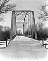
- DFU Elk Mountain Bridge: This bridge near Elk Mountain is an example of early engineering. It helped people cross rivers and move goods.
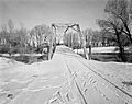
- DMJ Pick Bridge: Near Saratoga, this bridge also shows the importance of transportation. These old bridges are often beautiful structures that have stood the test of time.
- DML Butler Bridge: Located near Grand Encampment, this bridge is another historic crossing. It reminds us of the effort it took to build infrastructure in the past.
These are just some of the many amazing historic places in Carbon County. Each one has a unique story that helps us understand the rich history of Wyoming and the United States.
Images for kids
-
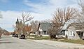
The historic community of Arlington.
-
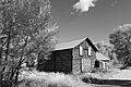
The Jim Baker Cabin, a rustic piece of history.
-
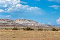
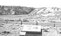
Como Bluff, famous for its dinosaur fossils.
-
The DFU Elk Mountain Bridge.
-
The DMJ Pick Bridge near Saratoga.
-
The DML Butler Bridge.
-
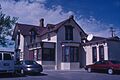
Buildings in the Downtown Rawlins Historic District.
-
The Elk Mountain Hotel.
-
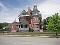
The George Ferris Mansion in Rawlins.
-
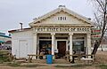
The First State Bank of Baggs.
-
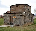
Fort Fred Steele, an important historic fort.
-
The unique Fossil Cabin, made of dinosaur bones.
-
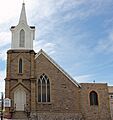
France Memorial United Presbyterian Church.
-
Hanna Community Hall.
-
The Medicine Bow Union Pacific Depot.
-
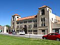
The Parco Inn, part of the Parco Historic District.
-
Homes in the Rawlins Residential Historic District.
-
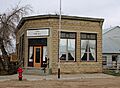
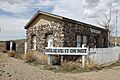
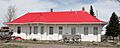
The historic Stockgrowers Bank in Dixon.
-
The Tom Sun Ranch, a National Historic Landmark.
-
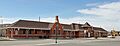
The Union Pacific Railroad Depot in Rawlins.
-
The Virginian Hotel in Medicine Bow.
-
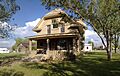
The Willis House in Grand Encampment.
-
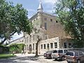
The Wyoming State Penitentiary District.


.JPG)


