
National Register of Historic Places listings in Cass County, Indiana facts for kids

Have you ever wondered about old buildings and places that are super important to history? In Cass County, Indiana, there are many special spots that are listed on the National Register of Historic Places. This is like a special list kept by the United States government to protect places that tell us about the past.
These places could be old houses, churches, or even whole neighborhoods! They are important because they show us how people lived, worked, and built things a long time ago. Cass County has 15 of these amazing places, and one of them is even a National Historic Landmark – that's like being extra, extra special!
Some of these historic places are in towns like Logansport, while others are in the countryside. Let's explore some of these cool historic sites!
Cool Historic Places in Cass County
Here are some of the interesting places in Cass County that are on the National Register of Historic Places:
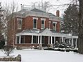
Josephus Atkinson Farm
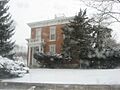
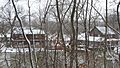
The Josephus Atkinson Farm is located west of Clymers. It was added to the National Register in 2010. This farm helps us understand what farming life was like in the past in Indiana.
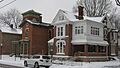
Bankers Row Historic District
In Logansport, you can find the Bankers Row Historic District. This area includes buildings along Eel River Avenue. It became a historic district in 1999. Imagine a street where many important banks and businesses used to be!
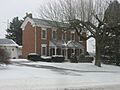
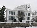
Thompson Barnett House
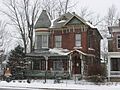
The Thompson Barnett House is a historic home located north of Logansport, near State Road 25. This house was recognized for its history in 1986. It's a great example of older homes in the area.
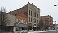
Courthouse Historic District
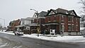
Also in Logansport is the Courthouse Historic District. This area, added in 1999, is roughly around 3rd and 6th Streets. It's named after the courthouse, which is often a very old and important building in a town.
Ferguson House
The Ferguson House is another historic home in Logansport, found at 803 East Broadway. It was added to the list in 1983. This house shows us the style of homes built many years ago.
Jerolaman-Long House
At 1004 East Market Street in Logansport, you'll find the Jerolaman-Long House. This building became a historic site in 1985. It's another example of the beautiful and important architecture from the past.
John Keip House
The John Keip House, located at 2500 East Broadway Avenue in Logansport, was added to the National Register in 2004. It's a significant part of the city's history.
Kendrick-Baldwin House
The Kendrick-Baldwin House is at 706 East Market Street in Logansport. It was recognized as a historic place in 1982. This house has stood for many years and holds stories from the past.
Pipe Creek Falls Resort
North of Walton, at the junction of County Roads 850 East and 275 South, is the Pipe Creek Falls Resort. This resort area was added to the list in 1995. It was likely a popular spot for people to relax and enjoy nature a long time ago.
Willard B. Place House
The Willard B. Place House is located at 900 East Broadway in Logansport. It became a historic site in 1998. This house is another piece of Logansport's rich architectural history.
Pleasant Hill Church
Southwest of Logansport, at the junction of County Roads 400 South and 675 West, stands the Pleasant Hill Church. This church was added to the National Register in 1996. Old churches often have interesting stories and beautiful designs.
Point Historic District
The Point Historic District in Logansport is another important neighborhood. It's roughly between Eel River Avenue, 3rd Street, and East Melbourne Avenue. This district was added in 1999 and shows how people lived and built their homes in the past.
Pollard-Nelson House
The Pollard-Nelson House is located at 7th and Market Streets in Logansport. It was added to the National Register in 1975, making it one of the earlier listings in the county.
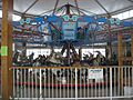
Spencer Park Dentzel Carousel
The Spencer Park Dentzel Carousel, located in Riverside Park in Logansport, is a very special place. It was added to the National Register in 1987 and is even a National Historic Landmark! Carousels like this are rare and bring joy to many people.
Henry Tousley House
The Henry Tousley House is at 1912 High Street in Logansport. This house was added to the list in 2002, preserving its history for future generations.
Former Listing
Sometimes, a place that was once on the National Register of Historic Places might be removed. This usually happens if the building is changed too much or is no longer there.
Washington School
The Washington School in Logansport was once on the National Register. It was listed in 1981 but was later removed in 1985.
Images for kids
-
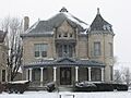
The Josephus Atkinson Farmhouse.
-
Buildings in the Bankers Row Historic District.
-
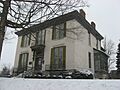
The historic Thompson Barnett House.
-
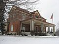
Buildings in the Courthouse Historic District of Logansport.
-
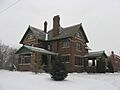
The Ferguson House in Logansport.
-
The Jerolaman-Long House.
-
The John Keip House.
-
The Kendrick-Baldwin House.
-
The Pipe Creek Falls Resort area.
-
The Willard B. Place House.
-
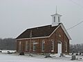
Pleasant Hill Church.
-
Homes in the Point Historic District.
-
The Pollard-Nelson House.
-
The Spencer Park Dentzel Carousel.
-
The Henry Tousley House.


