
National Register of Historic Places listings in Charlotte County, Florida facts for kids

Welcome to Charlotte County, Florida! Did you know that many special buildings and places here are protected because of their history? These places are listed on the National Register of Historic Places. This is a special list kept by the United States government. It helps save important buildings, sites, and objects from the past.
When a place is on this list, it means it's really important to American history, architecture, archaeology, engineering, or culture. Charlotte County has 17 such amazing places. Let's explore some of them and learn about their stories!
Contents
Historic Gems in Charlotte County
Homes with History
Some of the oldest and most interesting homes in Charlotte County are on the National Register. They show us how people lived long ago.
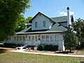
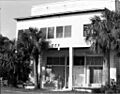
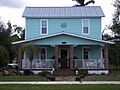
Clarence L. Babcock House
The Clarence L. Babcock House is a beautiful home in Punta Gorda. It was built a long time ago and added to the historic list in 2009. Imagine living in a house that has seen so much history!
A. C. Freeman House
Another historic home in Punta Gorda is the A. C. Freeman House]]. It was recognized in 1987. These old houses help us understand the past of the area.
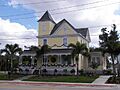
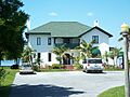
Villa Bianca
The Villa Bianca is also in Punta Gorda. This house joined the list in 1990. It's another example of the unique architecture from earlier times in Florida.
Important Buildings and Districts
Beyond homes, many other buildings and even whole areas are important enough to be protected. They tell us about how communities grew.
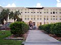
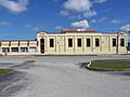
Charlotte High School
Charlotte High School in Punta Gorda is more than just a school. It's a historic building! It was added to the list in 1990. Think about all the students who have walked its halls over the years.
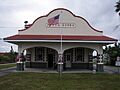
El Jobean Hotel
The El Jobean Hotel in El Jobean was listed in 1999. Hotels like this were once busy places where travelers and locals gathered. It shows us how tourism and travel developed in the area.
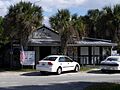
El Jobean Post Office and General Store
Right near the hotel is the El Jobean Post Office and General Store]]. This building was also listed in 1999. In the past, general stores were like today's supermarkets, selling everything people needed. The post office was where everyone sent and received letters.
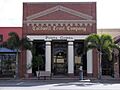
Old First National Bank of Punta Gorda
The Old First National Bank of Punta Gorda was added to the list in 1991. Banks are important because they show how towns grew and how people managed their money. This building tells a story of business and growth.
Punta Gorda Atlantic Coast Line Depot
Train stations were once very important for travel and trade. The Punta Gorda Atlantic Coast Line Depot was listed in 1990. It reminds us of the days when trains were a main way to get around Florida.
Punta Gorda Ice Plant
The Punta Gorda Ice Plant was added to the list in 1990. Before refrigerators were common, ice plants made ice to keep food fresh. This building shows us how people lived before modern technology.
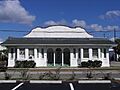
Punta Gorda Woman's Club
The Punta Gorda Woman's Club was recognized in 1991. Woman's clubs were important places where women gathered to work on community projects and support each other. This building represents their contributions to the town.
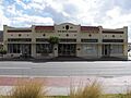
H. W. Smith Building
The H. W. Smith Building in Punta Gorda was listed in 1991. This building is another example of the historic commercial buildings that shaped the town's center.
Punta Gorda Residential District
Sometimes, not just one building, but a whole area is historic. The Punta Gorda Residential District was listed in 1991. This means many homes in this area are important together. Walking through it is like taking a trip back in time!
Unique and Archeological Sites
Some historic places are not buildings at all, but ancient sites or special structures.
Big Mound Key-Boggess Ridge Archeological District
The Big Mound Key-Boggess Ridge Archeological District is a very old site near Placida. It was added to the list in 1990. Archeological sites like this help scientists learn about the very first people who lived in Florida thousands of years ago. They often contain ancient shell mounds or tools.
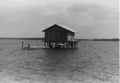
Historic Fish Cabins of Charlotte Harbor
Charlotte Harbor has several historic "fish cabins" that are on the list. These include the Icing Station at Bull Bay, the West Coast Fish Company Residential Cabin at Bull Bay, and the Willis Fish Cabin at Bull Bay. These cabins were used by fishermen long ago. They show us how important fishing was to the economy and daily life in this coastal area. They were added to the list in 1991.
Mott Willis Store
The Mott Willis Store in Charlotte Harbor was listed in 1997. Sadly, this building was demolished in 1998. Even though it's gone, its listing reminds us of its past importance to the community.
Images for kids
-
Clarence L. Babcock House
-

Big Mound Key-Boggess Ridge Archeological District (address restricted)
-
Charlotte High School
-

El Jobean Hotel
-
El Jobean Post Office and General Store
-
A. C. Freeman House
-
Mott Willis Store (demolished)
-
Old First National Bank of Punta Gorda
-
Punta Gorda Atlantic Coast Line Depot
-
Punta Gorda Ice Plant
-
A home in the Punta Gorda Residential District
-
Punta Gorda Woman's Club
-
H. W. Smith Building
-
Villa Bianca
-
Willis Fish Cabin at Bull Bay


.JPG)


