
National Register of Historic Places listings in Clay County, Kentucky facts for kids

This page tells you about special places in Clay County, Kentucky, that are listed on the National Register of Historic Places. This is like a national list of important buildings, sites, and objects that are worth saving. These places tell us a lot about history and culture.
There are four places in Clay County that are currently on this list. One other place was on the list but has since been removed.
Contents
Cool Historic Places in Clay County, Kentucky
Fish Trap Rock Petroglyphs
The Fish Trap Rock Petroglyphs are ancient carvings made on rocks. These carvings are found on the western bank of the Red Bird River near Eriline, Kentucky. They are very old and give us clues about the people who lived here long ago. Scientists believe these carvings were made by Native Americans. They show us how people used to live and what was important to them.
Peabody-Fordson Historic District
The Peabody-Fordson Historic District is a special area near Big Creek, Kentucky. It was added to the National Register in 2017. This district likely includes old buildings or areas that show how people lived and worked in the past. It helps us understand the history of communities in Clay County.
Red Bird River Shelter Petroglyphs
The Red Bird River Shelter Petroglyphs are another set of ancient rock carvings. These are located near Manchester, Kentucky. Like the Fish Trap Rock Petroglyphs, these carvings are very important for understanding the early history of the area. They are found in a rock shelter, which might have been a place where early people lived or visited often.
Sullen Possum Site
The Sullen Possum Site is an important historical location near Oneida, Kentucky. It was added to the National Register in 1993. This site helps historians and archaeologists learn more about the past. It might contain artifacts or evidence of ancient settlements.
Former Listing
Red Bird River Petroglyphs
The Red Bird River Petroglyphs were once on the National Register of Historic Places. They were also located near Manchester, Kentucky. This site was added to the list in 1989 but was removed in 2003. Sometimes, a site might be removed if it changes a lot, or if it's no longer considered to meet the strict rules for the list.
Images for kids
-
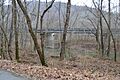
A view of the Fish Trap Rock Petroglyphs site.
-
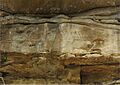
An image related to the Red Bird River Petroglyphs.


