
National Register of Historic Places listings in Concordia Parish, Louisiana facts for kids

This article is about special places in Concordia Parish, Louisiana. These places are so important that they are listed on the National Register of Historic Places. This is a list kept by the United States government. It helps protect buildings, sites, and objects that are important in American history, architecture, archaeology, engineering, or culture.
Concordia Parish is in the state of Louisiana. It has 13 places listed on the National Register. One place was on the list before but has since been removed. You can even see where some of these places are on a map if their location coordinates are shared.
Contents
What is the National Register of Historic Places?
The National Register of Historic Places is like a special club for important historical sites. It's the official list of the nation's historic places worth saving. When a place is added to this list, it means it's recognized for its unique history or design. This helps people learn about the past and protect these sites for the future.
Historic Places in Concordia Parish
Concordia Parish is home to several fascinating historic sites. These places tell stories about the past, from old plantations to unique buildings and even ancient mounds.
Old Homes and Plantations
Many of the listings in Concordia Parish are historic homes or parts of old plantations. These places give us a peek into how people lived long ago.
Canebrake
Canebrake is a historic home located northeast of Ferriday. It was added to the National Register in 1982. This old house stands as a reminder of the area's past.
Frogmore Plantation
Frogmore is a very old plantation near Ferriday. It was established around 1815. This site is famous for its steam-powered cotton gin. A cotton gin is a machine that quickly separates cotton fibers from their seeds. Frogmore is so well-known that it's been called a "Must See Site" by Rand-McNally. It's also one of the top three favorite attractions in the tri-state area of Arkansas, Louisiana, and Mississippi.
Killarney
Killarney is another historic property near Ferriday. It was listed in 1999. It's located on Louisiana Highway 569.
Lisburn Plantation House
The Lisburn Plantation House is southeast of Ferriday. This historic house was added to the list in 1979.
Roseland
Roseland is a historic home in Ferriday. It was listed in 1985. You can find it on Fisherman Drive.
Tacony Plantation House
The Tacony Plantation House is located off U.S. Route 84 near Vidalia. This old plantation house was recognized in 1979.
Important Buildings and Sites
Beyond homes, other types of buildings and sites in Concordia Parish have historical importance.
Concordia Parish Courthouse
The Concordia Parish Courthouse is in Vidalia. This important building, where local laws and decisions are made, was listed in 2004. It stands at 405 Carter Street.
Ferriday Commercial Historic District
The Ferriday Commercial Historic District is a special area in downtown Ferriday. It includes several blocks of buildings that show what the town looked like long ago. This district was added to the list in 1995. It's roughly bordered by 1st Street, Louisiana Avenue, 3rd Street, and Mississippi Avenue.
Piazza Cotton Gin
The Piazza Cotton Gin is part of the Frogmore Plantation. This specific cotton gin was listed separately in 1999. It highlights the importance of cotton farming in the region's history.
Zappe Boarding House
The Zappe Boarding House is in Ferriday. A boarding house is a place where people could rent a room and often get meals. This historic building was listed in 1999. It's located at 107 Virginia Avenue.
Ancient Mounds and Unique Finds
Some listings are much older, showing signs of ancient cultures or unique historical objects.
DePrato Mounds
The DePrato Mounds are ancient earth mounds near Ferriday. These mounds are very old and tell us about the people who lived in this area thousands of years ago. Because they are so important and fragile, their exact address is kept private. They were listed in 1998.
Frogmore Mound Site
The Frogmore Mound Site is another ancient mound site near Frogmore, Louisiana. Like the DePrato Mounds, this site gives archaeologists clues about early Native American cultures. It was listed in 2004, and its address is also restricted to protect it.
MAMIE S. BARRETT (towboat)
The MAMIE S. BARRETT is a unique listing. It's a towboat that is now on land at Deer Park, near Vidalia. A towboat is a powerful boat used to push barges along rivers. This towboat has been beached since a big flood in 1993. It was listed in 1983, showing the importance of river travel and industry in the area's past.
Former Listings
Sometimes, a place might be removed from the National Register. This usually happens if it's destroyed or changed so much that it no longer has its historic value.
Sheriff Eugene P. Campbell House
The Sheriff Eugene P. Campbell House in Vidalia was once on the list. It was added in 1979. However, it was removed from the list in 2016. This was because the house was destroyed by a fire in January 1991.
Images for kids
-
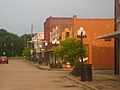
A street view of the Ferriday Commercial Historic District.
-
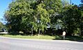
One of the ancient mounds at the Frogmore Mound Site.


