
National Register of Historic Places listings in Crawford County, Iowa facts for kids

This page tells you about some really cool old buildings, bridges, and places in Crawford County, Iowa that are super important! They are all part of a special list called the National Register of Historic Places. This list helps make sure these amazing spots are protected and remembered for a long time.
There are 12 different places in Crawford County that have made it onto this important list. Each one has a unique story and history!
Historic Places in Crawford County, Iowa
Buck Grove Bridge
The Buck Grove Bridge is a historic bridge located in Buck Grove, Iowa. It crosses over Buck Creek. This bridge was added to the National Register in 1998, meaning it's an important part of the area's history.
John T. and Marietta (Greek) Carey House

This beautiful house is in Denison, Iowa. It was designed by a famous architect named George Franklin Barber. The Carey House was added to the historic list in 2005.
Clarence D. Chamberlin House

Also located in Denison, Iowa, the Clarence D. Chamberlin House is another important historic home. It was recognized as a historic place way back in 1977.
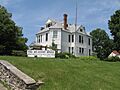
Crawford County Courthouse

The Crawford County Courthouse is a very important building in Denison, Iowa. It's where a lot of the county's official business happens. This courthouse became a historic landmark in 1981.
Simon E. Dow House

You can find the Dow House in Dow City, Iowa. This house belonged to Simon E. Dow, an important person in the area's past. It was added to the National Register in 1972.
Z.T. Dunham Pioneer Stock Farm
The Z.T. Dunham Pioneer Stock Farm is located near Dunlap, Iowa. This farm is a reminder of the early days of farming and settlement in the region. It was listed as historic in 1993.
Klondike Hotel
The Klondike Hotel is a historic building in Manilla, Iowa. Hotels like this were once busy places where travelers would stay. This hotel was added to the list in 1996.
William A. McHenry House

Another significant house in Denison, Iowa is the William A. McHenry House. It was recognized for its historical value in 1976.
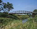
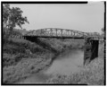
Nishnabotna River Bridges
There are two different bridges over the Nishnabotna River that are on the historic list.
- One is the Nishnabotna River Bridge on 310th Street, near Manilla, Iowa. It was listed in 1999.
- The other Nishnabotna River Bridge is on T Avenue, also near Manilla, Iowa. This one was added in 1998.
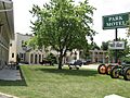
Park Motel

The Park Motel in Denison, Iowa is a historic motel. Motels were a popular place for people to stay when traveling by car. This motel was added to the National Register in 2000.
Yellow Smoke Park Bridge
The Yellow Smoke Park Bridge is a pedestrian bridge in Denison, Iowa. It's a special bridge found within Yellow Smoke Park. This bridge became a historic listing in 1998.
Images for kids
-
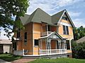
The John T. and Marietta (Greek) Carey House in Denison, Iowa.
-
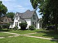
The Clarence D. Chamberlin House in Denison, Iowa.
-
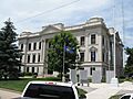
The Crawford County Courthouse in Denison, Iowa.
-
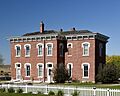
The Simon E. Dow House in Dow City, Iowa.
-
The William A. McHenry House in Denison, Iowa.
-
The Nishnabotna River Bridge on 310th Street.
-
The Nishnabotna River Bridge on T Avenue.
-
The Park Motel in Denison, Iowa.

