kids encyclopedia robot

National Register of Historic Places listings in DeWitt County, Texas facts for kids

Kids Encyclopedia Facts
Dewitt County Texas
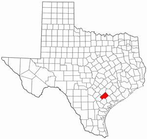
Location of DeWitt County in Texas

List of Registered Historic Places in DeWitt County, Texas

This is intended to be a complete list of properties and districts listed on the National Register of Historic Places in DeWitt County, Texas. The locations of National Register properties and districts (at least for all showing latitude and longitude coordinates below) may be seen in a map by clicking on "Map of all coordinates".


Name on the Register Image Date listed Location City or town Description
1 Bates-Sheppard House
Bates-Sheppard House
October 31, 1988
(#88001948)
312 E. Broadway
29°05′33″N 97°17′11″W / 29.0925°N 97.286389°W / 29.0925; -97.286389 (Bates-Sheppard House)
Cuero
2 John Y. Bell House
John Y. Bell House
October 31, 1988
(#88001982)
304 E. Prairie
29°05′46″N 97°17′07″W / 29.096111°N 97.285278°W / 29.096111; -97.285278 (John Y. Bell House)
Cuero
3 M. D. Bennett House
M. D. Bennett House
October 31, 1988
(#88001963)
208 N. Hunt
29°05′24″N 97°17′12″W / 29.09°N 97.286667°W / 29.09; -97.286667 (M. D. Bennett House)
Cuero
4 Billow-Thompson House
Billow-Thompson House
October 31, 1988
(#88001949)
402 E. Broadway
29°05′32″N 97°17′09″W / 29.092222°N 97.285833°W / 29.092222; -97.285833 (Billow-Thompson House)
Cuero
5 Breeden-Runge Wholesale Grocery Company Building
Breeden-Runge Wholesale Grocery Company Building
October 31, 1988
(#88001957)
108 N. Frederick William
29°05′32″N 97°17′43″W / 29.092222°N 97.295278°W / 29.092222; -97.295278 (Breeden-Runge Wholesale Grocery Company Building)
Cuero
6 Floyd Buchel House
Floyd Buchel House
October 31, 1988
(#88001950)
407 E. Broadway
29°05′29″N 97°17′09″W / 29.091389°N 97.285833°W / 29.091389; -97.285833 (Floyd Buchel House)
Cuero
7 Arthur Burns House
Arthur Burns House
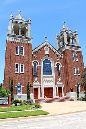
October 31, 1988
(#88001987)
130 E. Sarah
29°05′44″N 97°17′14″W / 29.095556°N 97.287222°W / 29.095556; -97.287222 (Arthur Burns House)
Cuero
8 John W. Burns House
John W. Burns House
October 31, 1988
(#88001947)
311 E. Broadway
29°05′31″N 97°17′13″W / 29.091944°N 97.286944°W / 29.091944; -97.286944 (John W. Burns House)
Cuero
9 Callaway-Gillette House
Callaway-Gillette House
October 31, 1988
(#88001989)
306 E. Sarah
29°05′42″N 97°17′07″W / 29.095°N 97.285278°W / 29.095; -97.285278 (Callaway-Gillette House)
Cuero
10 J. B. Chaddock House
J. B. Chaddock House
October 31, 1988
(#88001995)
202 S. Valley
29°05′10″N 97°17′06″W / 29.086111°N 97.285°W / 29.086111; -97.285 (J. B. Chaddock House)
Cuero
11 City Water Works
City Water Works
October 31, 1988
(#88001956)
208 S. Esplanade
29°05′21″N 97°17′33″W / 29.089167°N 97.2925°W / 29.089167; -97.2925 (City Water Works)
Cuero
12 Clement-Nagel House
Clement-Nagel House
October 31, 1988
(#88001974)
701 E. Morgan
29°05′07″N 97°17′10″W / 29.085278°N 97.286111°W / 29.085278; -97.286111 (Clement-Nagel House)
Cuero
13 Colston-Gohmert House
Colston-Gohmert House
October 31, 1988
(#88001983)
309 E. Prairie
29°05′44″N 97°17′06″W / 29.095556°N 97.285°W / 29.095556; -97.285 (Colston-Gohmert House)
Cuero
14 Charles Cook House
October 31, 1988
(#88001986)
103 E. Sarah
29°05′44″N 97°17′17″W / 29.095556°N 97.288056°W / 29.095556; -97.288056 (Charles Cook House)
Cuero Demolished
15 W. H. Crain House
W. H. Crain House
October 31, 1988
(#88001953)
508 E. Courthouse
29°05′25″N 97°17′08″W / 29.09034°N 97.28544°W / 29.09034; -97.28544 (W. H. Crain House)
Cuero
16 Cuero Commercial Historic District
Cuero Commercial Historic District
November 17, 1988
(#88001996)
Roughly bounded by Gonzales, Main, Terrell and Courthouse
29°05′28″N 97°17′27″W / 29.091111°N 97.290833°W / 29.091111; -97.290833 (Cuero Commercial Historic District)
Cuero
17 Cuero Gin
October 31, 1988
(#88001970)
501 W. Main
29°05′30″N 97°17′44″W / 29.091667°N 97.295556°W / 29.091667; -97.295556 (Cuero Gin)
Cuero Demolished by 2005
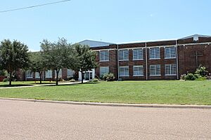
18 Cuero High School
Cuero High School
October 31, 1988
(#88001990)
405 E. Sarah
29°05′55″N 97°17′04″W / 29.098611°N 97.284444°W / 29.098611; -97.284444 (Cuero High School)
Cuero
19 Cuero Hydroelectric Plant
September 19, 1977
(#77001514)
2 mi (3.2 km). N of Cuero on Guadalupe Plant
29°07′46″N 97°18′40″W / 29.129444°N 97.311111°W / 29.129444; -97.311111 (Cuero Hydroelectric Plant)
Cuero
20 Cuero I Archeological District
October 9, 1974
(#74002271)
Address Restricted
Cuero Extends into Gonzales County
21 E. A. Daule House
October 31, 1988
(#88001981)
201 W. Newman
29°05′23″N 97°17′52″W / 29.089722°N 97.297778°W / 29.089722; -97.297778 (E. A. Daule House)
Cuero
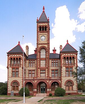
22 DeWitt County Courthouse
DeWitt County Courthouse
May 6, 1971
(#71000929)
Bounded by N. Gonzales, E. Live Oak, N. Clinton, and E. Courthouse Sts.
29°05′29″N 97°17′19″W / 29.091389°N 97.288611°W / 29.091389; -97.288611 (DeWitt County Courthouse)
Cuero
23 East Main Street Residential Historic District
East Main Street Residential Historic District
October 31, 1988
(#88001998)
400 to 800 blks. of E. Main St.
29°05′16″N 97°17′07″W / 29.087778°N 97.285278°W / 29.087778; -97.285278 (East Main Street Residential Historic District)
Cuero
24 Eckhardt Stores
Eckhardt Stores
June 29, 1976
(#76002020)
Eckhardt and Main St.
28°58′49″N 97°30′13″W / 28.980278°N 97.503611°W / 28.980278; -97.503611 (Eckhardt Stores)
Yorktown
25 William and L. F. Eichholz House
William and L. F. Eichholz House
October 31, 1988
(#88001954)
308 W. Courthouse
29°05′37″N 97°17′39″W / 29.093585°N 97.294073°W / 29.093585; -97.294073 (William and L. F. Eichholz House)
Cuero
26 English-German School
English-German School
October 31, 1988
(#88001978)
201 E. Newman
29°05′09″N 97°17′30″W / 29.085833°N 97.291667°W / 29.085833; -97.291667 (English-German School)
Cuero Building is condemned
27 J. B. Farris House
October 31, 1988
(#88001960)
502 N. Gonzales
29°05′36″N 97°17′18″W / 29.093333°N 97.288333°W / 29.093333; -97.288333 (J. B. Farris House)
Cuero Demolished
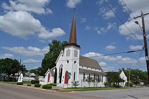
28 First Methodist Church
First Methodist Church
October 31, 1988
(#88001952)
301 E. Courthouse
29°05′27″N 97°17′17″W / 29.090833°N 97.288056°W / 29.090833; -97.288056 (First Methodist Church)
Cuero
29 Alfred Friar House
Alfred Friar House
October 31, 1988
(#88001961)
703 N. Gonzales
29°05′42″N 97°17′13″W / 29.095°N 97.286944°W / 29.095; -97.286944 (Alfred Friar House)
Cuero
30 William Frobese Sr. House
William Frobese Sr. House
October 31, 1988
(#88001980)
305 E. Newman
29°05′07″N 97°17′24″W / 29.085278°N 97.29°W / 29.085278; -97.29 (William Frobese Sr. House)
Cuero
31 Grace Episcopal Church
Grace Episcopal Church
October 31, 1988
(#88001955)
401 N. Esplanade
29°05′33″N 97°17′23″W / 29.0925°N 97.289722°W / 29.0925; -97.289722 (Grace Episcopal Church)
Cuero
32 House at 1002 Stockdale
House at 1002 Stockdale
October 31, 1988
(#88001993)
1002 Stockdale
29°04′47″N 97°17′37″W / 29.079722°N 97.293611°W / 29.079722; -97.293611 (House at 1002 Stockdale)
Cuero
33 House at 404 Stockdale
House at 404 Stockdale
October 31, 1988
(#88001992)
404 Stockdale
29°05′07″N 97°17′27″W / 29.085278°N 97.290833°W / 29.085278; -97.290833 (House at 404 Stockdale)
Cuero
34 House at 609 East Live Oak
House at 609 East Live Oak
October 31, 1988
(#88001968)
609 E. Live Oak
29°05′24″N 97°17′02″W / 29.09°N 97.283889°W / 29.09; -97.283889 (House at 609 East Live Oak)
Cuero
35 Keller-Grunder House
Keller-Grunder House
October 31, 1988
(#88001973)
409 E. Morgan
29°05′11″N 97°17′19″W / 29.086389°N 97.288611°W / 29.086389; -97.288611 (Keller-Grunder House)
Cuero
36 Albert and Kate Leinhardt House
Albert and Kate Leinhardt House
October 31, 1988
(#88001976)
818 E. Morgan
29°05′11″N 97°17′01″W / 29.086389°N 97.283611°W / 29.086389; -97.283611 (Albert and Kate Leinhardt House)
Cuero
37 Emil Leonardt House
Emil Leonardt House
November 4, 1988
(#88001975)
804 E. Morgan
29°05′07″N 97°17′05″W / 29.085278°N 97.284722°W / 29.085278; -97.284722 (Emil Leonardt House)
Cuero
38 Leske Bar
October 31, 1988
(#88001969)
432 W. Main
29°05′30″N 97°17′41″W / 29.091667°N 97.294722°W / 29.091667; -97.294722 (Leske Bar)
Cuero Demolished by 2005, after being damaged in a flood in 1998
39 Valentine Ley House
Valentine Ley House
October 31, 1988
(#88001979)
206 E. Newman
29°05′10″N 97°17′30″W / 29.086111°N 97.291667°W / 29.086111; -97.291667 (Valentine Ley House)
Cuero
40 Lynch-Probst House
October 31, 1988
(#88001951)
502 E. Broadway
29°05′31″N 97°17′06″W / 29.091944°N 97.285°W / 29.091944; -97.285 (Lynch-Probst House)
Cuero Demolished
41 Macedonia Baptist Church
Macedonia Baptist Church
October 31, 1988
(#88001967)
512 S. Indianola
29°05′12″N 97°17′54″W / 29.086667°N 97.298333°W / 29.086667; -97.298333 (Macedonia Baptist Church)
Cuero
42 Frank Marie House
Frank Marie House
October 31, 1988
(#88001959)
402 E. French
29°05′36″N 97°17′07″W / 29.093333°N 97.285278°W / 29.093333; -97.285278 (Frank Marie House)
Cuero
43 May-Hickey House
October 27, 1988
(#88002129)
FM 682 1.7 mi. S of jct. with TX 111
29°15′39″N 97°08′40″W / 29.260833°N 97.144444°W / 29.260833; -97.144444 (May-Hickey House)
Yoakum
44 Meissner-Pleasants House
Meissner-Pleasants House
October 31, 1988
(#88001962)
108 N. Hunt
29°05′21″N 97°17′12″W / 29.089167°N 97.286667°W / 29.089167; -97.286667 (Meissner-Pleasants House)
Cuero
45 Edward Mugge House
Edward Mugge House
October 31, 1988
(#88001994)
218 N. Terrell
29°05′30″N 97°17′33″W / 29.091667°N 97.2925°W / 29.091667; -97.2925 (Edward Mugge House)
Cuero
46 Municipal Power Plant
Municipal Power Plant
November 15, 1996
(#96001356)
810 Front St.
29°17′08″N 97°09′04″W / 29.285556°N 97.151111°W / 29.285556; -97.151111 (Municipal Power Plant)
Yoakum Now the city library
47 Old Beer and Ice Warehouse
Old Beer and Ice Warehouse
October 31, 1988
(#88001985)
104 SW Railroad
29°05′23″N 97°17′33″W / 29.089754°N 97.292525°W / 29.089754; -97.292525 (Old Beer and Ice Warehouse)
Cuero
48 Charles J. and Alvina Ott House
Charles J. and Alvina Ott House
October 31, 1988
(#88001965)
306 N. Hunt
29°05′27″N 97°17′10″W / 29.090833°N 97.286111°W / 29.090833; -97.286111 (Charles J. and Alvina Ott House)
Cuero
49 S. I. Ott House
S. I. Ott House
October 31, 1988
(#88001964)
302 N. Hunt
29°05′26″N 97°17′11″W / 29.090556°N 97.286389°W / 29.090556; -97.286389 (S. I. Ott House)
Cuero
50 O. F. and Mary Prigden House
O. F. and Mary Prigden House
October 31, 1988
(#88001958)
401 E. French
29°05′34″N 97°17′08″W / 29.092778°N 97.285556°W / 29.092778; -97.285556 (O. F. and Mary Prigden House)
Cuero
51 J. M. Reuss House
J. M. Reuss House
October 31, 1988
(#88001991)
315 Stockdale
29°05′09″N 97°17′24″W / 29.085833°N 97.29°W / 29.085833; -97.29 (J. M. Reuss House)
Cuero
52 St. Michael's Catholic Church
St. Michael's Catholic Church
October 31, 1988
(#88001971)
202 N. McLeod
29°05′24″N 97°17′15″W / 29.09°N 97.2875°W / 29.09; -97.2875 (St. Michael's Catholic Church)
Cuero
53 State Highway 27 Bridge at the Guadalupe River
State Highway 27 Bridge at the Guadalupe River
October 10, 1996
(#96001122)
US 87, .13 mi. S of jct. with US 183
29°03′55″N 97°19′20″W / 29.065278°N 97.322222°W / 29.065278; -97.322222 (State Highway 27 Bridge at the Guadalupe River)
Cuero
54 Elisha Stevens House
Elisha Stevens House
October 31, 1988
(#88001984)
408 E. Prairie
29°05′44″N 97°17′02″W / 29.095556°N 97.283889°W / 29.095556; -97.283889 (Elisha Stevens House)
Cuero
55 Terrell-Reuss Streets Historic District
Terrell-Reuss Streets Historic District
October 31, 1988
(#88001997)
300 to 900 blks. of Terrell, 500 to 900 blks. of Indianola, and 200 blk. of W. Reuss to 400 blk. of E. Reuss
29°05′44″N 97°17′18″W / 29.095556°N 97.288333°W / 29.095556; -97.288333 (Terrell-Reuss Streets Historic District)
Cuero
56 W. F. Thomson House
W. F. Thomson House
October 31, 1988
(#88001972)
608 N. McLeod
29°05′37″N 97°17′08″W / 29.093611°N 97.285556°W / 29.093611; -97.285556 (W. F. Thomson House)
Cuero
57 Dane Wittenbert House
Dane Wittenbert House
October 31, 1988
(#88001966)
402 S. Hunt
29°05′05″N 97°17′20″W / 29.084722°N 97.288889°W / 29.084722; -97.288889 (Dane Wittenbert House)
Cuero
58 Charles Wittmer House
Charles Wittmer House
October 31, 1988
(#88001977)
110 E. Newman
29°05′11″N 97°17′33″W / 29.086389°N 97.2925°W / 29.086389; -97.2925 (Charles Wittmer House)
Cuero
59 Wofford-Finney House
Wofford-Finney House
August 14, 1992
(#92000984)
202 E. Prairie St.
29°05′48″N 97°17′11″W / 29.096667°N 97.286389°W / 29.096667; -97.286389 (Wofford-Finney House)
Cuero
kids search engine
National Register of Historic Places listings in DeWitt County, Texas Facts for Kids. Kiddle Encyclopedia.