
National Register of Historic Places listings in El Paso County, Texas facts for kids

This page is a list of amazing places in El Paso County, Texas that are part of the National Register of Historic Places. These are special spots recognized for their history, architecture, or importance to the local area.
The National Register of Historic Places is like a special club for buildings, sites, and districts that are important to American history. In El Paso County, there are 13 historic areas (called "districts"), one very important national landmark, and 44 individual buildings or sites. There was also one place that used to be on the list but isn't anymore.
Two of these places are also State Historic Sites, which means they are important to Texas history. Nine sites are also known as Recorded Texas Historic Landmarks. Three of these are even more special, called State Antiquities Landmarks.
Contents
Cool Historic Places in El Paso County
Many places in El Paso County are on the National Register because they tell important stories about the past. Let's explore some of them!
Buildings with a Story
El Paso has many old buildings that are still standing and have amazing histories.
Downtown El Paso's Historic Buildings
Several buildings in downtown El Paso were designed by a famous architect named Henry C. Trost.
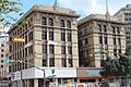
- Abdou Building: Located at 115 N. Mesa Street, this building was listed on September 24, 1980. It's a great example of early 20th-century architecture.
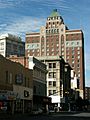
- O. T. Bassett Tower: You can find this tall building at 301 Texas Avenue. It was also listed on September 24, 1980, and is another example of Trost's work.
- Richard Caples Building: At 300 E. San Antonio Avenue, this building joined the list on September 24, 1980.
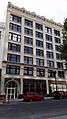
- First Mortgage Company Building: This building at 109 N. Oregon Street was added on June 13, 1978.
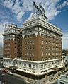
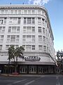
- Hotel Cortez: Located at 300 N. Mesa Street, this hotel was listed on September 24, 1980. It's also a Recorded Texas Historic Landmark.
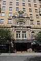
- Hotel Paso del Norte: This beautiful hotel at 115 El Paso Street was listed on January 5, 1979.
- J. J. Newberry Company: This old store at 201-205 N. Stanton Street was listed on September 24, 1980.
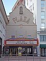
- Palace Theatre: Once a grand theater at 209 S. El Paso Street, it was listed on September 24, 1980. It was also known as the Alhambra Theatre.
- Plaza Hotel: Found at Oregon and Mills Streets, this hotel was listed on September 24, 1980.
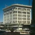
- Popular Department Store: This historic department store at 102 N. Mesa Street was added on September 24, 1980.
- Roberts-Banner Building: At 215 N. Mesa Street, this building was listed on September 24, 1980.
- Singer Sewing Company Building: This building at 211 Texas Avenue was listed on September 24, 1980, and is a Recorded Texas Historic Landmark.
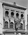
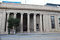
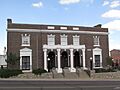
- State National Bank: Located at 114 E. San Antonio Avenue, this bank was listed on September 24, 1980.
- White House Department Store and Hotel McCoy: This combined building at 109 Pioneer Plaza was listed on September 24, 1980.
Other Important Buildings
- El Paso High School: This historic school at 1600 N. Virginia Street was listed on November 17, 1980.
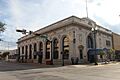
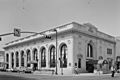
- El Paso Union Passenger Station: The old train station at the SW corner of Coldwell and San Francisco Street was listed on April 3, 1975.
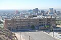
- El Paso US Courthouse: The courthouse at 511 W. San Antonio Avenue was listed on April 25, 2001.
- House at 912 Magoffin Avenue: This historic home was listed on June 23, 2003.
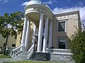
- Magoffin Homestead: Located at 1120 Magoffin Avenue, this home was listed on March 31, 1971. It's a State Historic Site and a State Antiquities Landmark.
- Martin Building: At 215 N. Stanton Street, this building was listed on August 8, 1984, and is a Recorded Texas Historic Landmark.
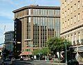
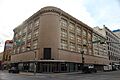
- Mills Building: Found at 303 N. Oregon Street, this building was listed on March 21, 2011.
- Old Bnai Zion Synagogue: This synagogue at 906 N. El Paso Street was listed on August 16, 1984. It's a State Antiquities Landmark and a Recorded Texas Historic Landmark.
- Plaza Theatre: This beautiful theater at 125 Pioneer Plaza was listed on June 4, 1987.
- Silver Dollar Cafe: This cafe at 1021 S. Mesa was listed on August 14, 1986.
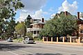
- Henry C. Trost House: The home of the famous architect, at 1013 W. Yandell Drive, was listed on July 12, 1976.
- U.S. Post Office (El Paso): The post office at 219 Mills Avenue was listed on July 19, 1984.
- Women's Club (El Paso, Texas): This club at 1400 N. Mesa Street was listed on July 22, 1979.
Historic Districts and Sites
These are larger areas or sites that include many historic elements.
- Castner Range Archeological District: This important archaeological site was listed on April 22, 1976. Its exact location is kept private to protect it.
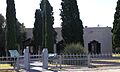
- Chamizal National Memorial: Located on Paisano Drive, this memorial was listed on February 4, 1974. It's a National Historic Landmark.
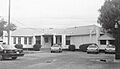
- El Paso County Water Improvement District No. 1: This district, important for water management, was listed on August 25, 1997.
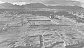
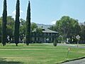
- Fort Bliss Main Post Historic District: The main area of Fort Bliss was listed on May 7, 1998.
- Fort Bliss National Cemetery: This cemetery at 5200 Fred Wilson Boulevard was listed on March 8, 2016.
- Franklin Canal (Texas): This canal, important for irrigation, was listed on June 19, 1992.
- Fusselman Canyon Rock Art District: This district, known for its ancient rock art, was listed on June 3, 1976. Its location is restricted for protection.
- Hot Well Archeological Site: This archaeological site was listed on April 30, 1976. Its location is restricted.
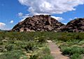
- Hueco Tanks State Historic Site: This site, famous for its rock formations and ancient art, was listed on July 14, 1971. It's a State Historic Site.
- Magoffin Historic District: This district, including many historic buildings, was listed on October 11, 2016.
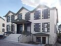
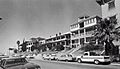
- Manhattan Heights Historic District: This historic neighborhood was listed on September 27, 1980.
- Mesa Pump Plant: This plant at 4901 Fred Wilson Avenue was listed on June 19, 2009.
- Mission Socorro Archeological Site: This archaeological site near Socorro was listed on January 22, 1993. Its location is restricted.
- Montana Avenue Historic District: This district along Montana Avenue was listed on November 13, 2004.
- Northgate Site: This archaeological site was listed on March 16, 1972. Its location is restricted.
- Old Fort Bliss: The original site of Fort Bliss was listed on February 23, 1972, and is a Recorded Texas Historic Landmark.
- Old San Francisco Historic District: This historic district was listed on May 21, 1985.
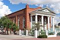
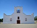
- Presidio Chapel of San Elizario: This historic chapel in San Elizario was listed on September 14, 1972, and is a Recorded Texas Historic Landmark.
- Quarters Number 1: This building at 228 Sheridan Road in Fort Bliss was listed on April 9, 1987.
- Rio Grande Avenue Historic District: This historic district was listed on September 9, 1999.
- Rio Vista Farm Historic District: This farm district in Socorro was listed on February 22, 1996.
- San Elizario Historic District: This historic district in San Elizario was listed on February 27, 1997.
- Sgt. Doyle Site: This archaeological site was listed on April 11, 1977. Its location is restricted.
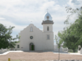
- Socorro Mission: This mission at Moon Road and TX 258 was listed on March 16, 1972. It's a State Antiquities Landmark and a Recorded Texas Historic Landmark.
- Sunset Heights Historic District: This historic neighborhood was listed on December 8, 1988.
- Toltec Club: This club at 602 Magoffin Avenue was listed on March 12, 1979.
- Ysleta Mission: This mission near TX 20 and Zaragosa Road in Ysleta was listed on July 31, 1972, and is a Recorded Texas Historic Landmark.
Former Listings
Sometimes, a place might be removed from the National Register of Historic Places. This can happen if the building is changed too much or if it is destroyed.
- 1800's Mexican Consulate: This building at 612 E. San Antonio Street in El Paso was listed on May 23, 1975, but was removed from the list on December 3, 2013.
Images for kids
-
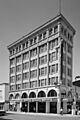
The Abdou Building in El Paso.
-
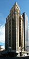
The O. T. Bassett Tower.
-
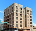
The Richard Caples Building.
-

Some sites have restricted addresses to protect them.
-
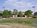
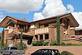
The Chamizal National Memorial visitor center.
-
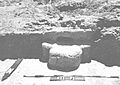
The Sgt. Doyle Site.
-
El Paso High School.
-
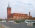
The El Paso Union Passenger Station.
-
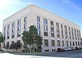
The El Paso US Courthouse.
-
The First Mortgage Company Building.
-
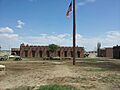
A view of the Fort Bliss Main Post Historic District.
-

Soldiers at Fort Bliss National Cemetery.
-
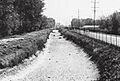
The Franklin Canal.
-
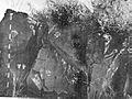
Rock art at Fusselman Canyon.
-
The Hot Well Archeological Site.
-
The historic Hotel Cortez.
-
The Hotel Paso del Norte.
-
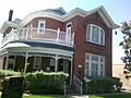
A historic house at 912 Magoffin Avenue.
-
Hueco Tanks State Historic Site.
-
The Magoffin Homestead.
-

A street view in the Manhattan Heights Historic District.
-
The Martin Building.
-
The Anson Mills Building.
-
A street in the Montana Avenue Historic District.
-
The J. J. Newberry Company building.
-
The Old Bnai Zion Synagogue.
-
Soldier's quarters at Old Fort Bliss.
-
A building in the Old San Francisco Historic District.
-
The Palace Theatre, also known as Alhambra Theatre.
-
The Plaza Hotel.
-
The beautiful Plaza Theatre.
-
The Popular Department Store.
-
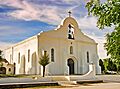
The Presidio Chapel of San Elizario.
-
Quarters Number 1 at Fort Bliss.
-
Rio Vista Farm Historic District.
-
The Roberts-Banner Building.
-
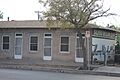
The Silver Dollar Cafe.
-
The Socorro Mission.
-
The State National Bank building.
-
A general view of the Sunset Heights Historic District.
-
The Henry C. Trost House.
-
The U.S. Post Office in El Paso.
-
The White House Department Store.
-
The El Paso Women's Club.
-
The Ysleta Mission.


