
National Register of Historic Places listings in Fairfield County, South Carolina facts for kids

Have you ever wondered about old buildings or special places that tell a story from the past? In Fairfield County, South Carolina, there are many such amazing spots! These places are so important that they are listed on the National Register of Historic Places. This is like a special list of historic buildings, sites, and districts across the United States.
Being on this list means a place is super important to American history, architecture, archaeology, engineering, or culture. It helps protect these places so future generations, like you, can learn from them. In Fairfield County, there are 43 places currently on this list. A few others were once listed but have since been removed, often because they were sadly torn down.
Contents
What is the National Register of Historic Places?
The National Register of Historic Places is the official list of the nation's historic places worth saving. It's managed by the National Park Service. When a place is added to this list, it means it has a special story to tell. It could be an old house, a church, a school, a battlefield, or even a whole neighborhood!
Why are these places important?
These historic places help us understand how people lived long ago. They show us what buildings looked like, how communities were formed, and what events happened there. By preserving them, we keep history alive. It's like having a giant outdoor museum right in your county!
Protecting historic sites in Fairfield County
Fairfield County is full of history, and many of its treasures are on this important list. These sites include old homes, churches, and even parts of old towns. They remind us of the people who lived here before us and the exciting stories of their lives.
Historic Places You Can Explore
Fairfield County has many different kinds of historic places. Some are old homes, others are churches, and some are even entire neighborhoods! Each one has a unique story.
Notable historic buildings and areas
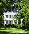
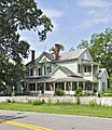
- Albion and Balwearie: These are old homes near Winnsboro. They show us how people lived in the past.
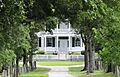
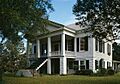
- Blink Bonnie: Located near Ridgeway, this is another historic home with a long history.
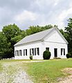
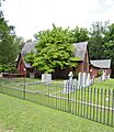
- Camp Welfare: This site near Ridgeway is important for its religious history. It's a place where people gathered for special events.
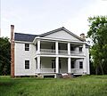
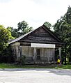
- Century House: Found in Ridgeway, this house has stood for over a hundred years. It's a great example of old architecture.
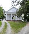
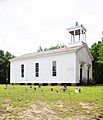
- Concord Presbyterian Church: This church near Winnsboro has been a community gathering place for a very long time.
- Davis Plantation and Fonti Flora Plantation: These sites near Monticello are examples of old plantations.
- Ebenezer Associate Reformed Presbyterian Church: Also known as "Old Brick Church," this church near Jenkinsville was built way back in 1788! Imagine how many stories its walls could tell.
- Ketchin Building: This building in Winnsboro is a historic commercial building. It shows what old downtown areas looked like.
- Liberty Universalist Church and Feasterville Academy Historic District: This district includes a historic church and an old academy. It tells us about education and religion in the past.
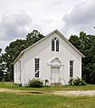
- Little River Baptist Church: Another historic church near Jenkinsville, showing the importance of faith in the community.
- Monticello Methodist Church and Monticello Store and Post Office: These buildings in Monticello show what a small town center used to be like.
- Mount Olivet Presbyterian Church: This church near Winnsboro is another significant religious site.
- New Hope A.R.P. Church and Session House: Located northwest of Winnsboro, this church and its session house are important historical structures.
- Old Stone House: This unique stone house near Winnsboro is a rare find and has a lot of history.
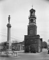
- Ridgeway Historic District: This is an entire area in Ridgeway with many historic buildings. Walking through it is like stepping back in time!
- Rockton and Rion Railroad Historic District: This district tells the story of the old railroad in the area. Railroads were super important for travel and trade long ago.
- Ruff's Chapel: Another historic chapel in Ridgeway.
- Rural Point: An old home in Winnsboro.
- St. Stephen's Episcopal Church: This church in Ridgeway was built in 1854. It was later covered with brick, but it still has its original charm.
- Shivar Springs Bottling Company Cisterns: These cisterns near Winnsboro are part of an old bottling company. It's cool to see how drinks were made in the past!
- The Oaks: A historic home near Winnsboro.
- Tocaland: Another historic property near Winnsboro.
- Vaughn's Stage Coach Stop: Imagine stagecoaches stopping here near Ridgeway! This place was important for travelers long ago.
- White Oak Historic District: Another historic neighborhood near Winnsboro.
- Monroe Wilson House: A historic house in Ridgeway.
- Winnsboro Historic District: Like Ridgeway, Winnsboro also has a large historic district. It includes many old buildings that show the town's past.
Places with restricted addresses
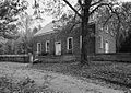
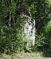
Some historic places, like the Blair Mound and McMeekin Rock Shelter, have "Address Restricted" listed. This usually means they are archaeological sites. Their exact locations are kept secret to protect them from harm. It's like a hidden treasure that scientists are studying!
Places No Longer on the List
Sometimes, a historic place is removed from the National Register. This can happen for different reasons. For example, the James Beard House and the Furman Institution Academic Building were once on the list but were later demolished. It's sad when historic places are lost, which is why protecting them is so important.
Images for kids
-
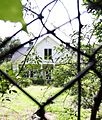
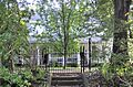
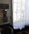
Balwearie, a historic home near Winnsboro.
-

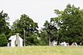
Some historic sites have restricted addresses to protect them.
-

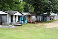
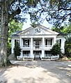
Blink Bonnie, a historic home near Ridgeway.
-
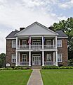
The Dr. Walter Brice House.
-
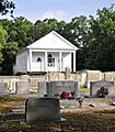
Camp Welfare, a historic religious site.
-
The Century House in Ridgeway.
-
Concord Presbyterian Church.
-

Davis Plantation.
-
Ebenezer Associate Reformed Presbyterian Church, also known as "Old Brick Church."
-
Fonti Flora Plantation.
-
The Dr. John Glenn House.
-
High Point, a historic site.
-
Hunstanton, a historic home.
-
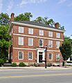
The Ketchin Building in Winnsboro.
-

Liberty Universalist Church.
-
Little River Baptist Church.
-
Monticello Methodist Church.
-
Monticello Store and Post Office.
-
Mount Olivet Presbyterian Church.
-

New Hope A.R.P. Church.
-
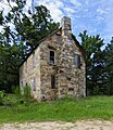
The Old Stone House.
-
A building in the Ridgeway Historic District.
-
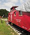
The Rockton and Rion Railroad Historic District.
-
Ruff's Chapel.
-
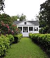
Rural Point, a historic home.
-
St. Stephen's Episcopal Church.
-
Shivar Springs Bottling Company Cisterns.
-
The Oaks, a historic home.
-
Tocaland.
-

Vaughn's Stage Coach Stop.
-

The White Oak Historic District.
-
The Monroe Wilson House.
-
A building in the Winnsboro Historic District.


.jpg)


.jpg)


.jpg)
