
National Register of Historic Places listings in Fayette County, Ohio facts for kids

Fayette County, Ohio, is home to many important historical places. These special spots are listed on the National Register of Historic Places. This is an official list kept by the United States government. It helps protect buildings, sites, and objects that are important to American history. When a place is on this list, it means it has a unique story to tell.
There are 17 places in Fayette County that are on the National Register. They include old houses, a courthouse, a chapel, a bridge, and even a historic cemetery. Each one helps us learn about the past of this area.
Contents
Discovering Fayette County's Historic Places
Let's explore some of the interesting places in Fayette County that are listed on the National Register of Historic Places. These sites help us understand the history and culture of the area.
Historic Homes and Buildings
Many old homes and buildings in Fayette County have been recognized for their historical value. They show us how people lived and worked long ago.
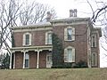
William Burnett House
The William Burnett House was located at 1613 U.S. Route 62, southwest of Washington Court House. It was added to the list on March 22, 1989. Sadly, this house has since been destroyed.
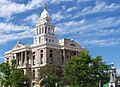
Fayette County Courthouse
The Fayette County Courthouse stands proudly at Main and Columbus Streets in Washington Court House. This important building was listed on July 2, 1973. It is where many local government decisions are made.
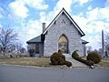
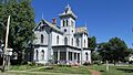
Judy Chapel
The Judy Chapel is found at 1741 Washington Avenue in Washington Court House. It became a historic site on May 8, 1998. Chapels like this often have beautiful architecture and a peaceful history.
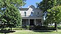
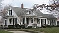
Barney Kelley House
The Barney Kelley House is at 321 East East Street in Washington Court House. It was added to the list on April 17, 1979. This house is a good example of older homes in the area.
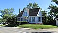
Jacob Light House
You can find the Jacob Light House at 123 West Circle Avenue in Washington Court House. It was recognized on January 13, 1989. It's another example of the historic homes in the county.
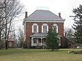
William McCafferty Farmhouse
The William McCafferty Farmhouse is located at 7099 State Route 207, northeast of Mount Sterling in Madison Township. This farm was listed on April 23, 1987. Old farmhouses tell us about the agricultural history of the region.
Rawlings-Brownell House
The Rawlings-Brownell House is at 318 Rawlings Street in Washington Court House. It joined the list on March 10, 1988. This house adds to the collection of historic homes in the city.
Robinson-Pavey House
The Robinson-Pavey House is located at 421 West Court Street in Washington Court House. It was added on April 23, 1987. It's another significant historic home.
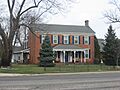
Morris Sharp House
The Morris Sharp House is at 517 Columbus Street in Washington Court House. It was listed on January 21, 1974. This house is a notable part of the city's past.
Edward Smith, Jr., Farm
The Edward Smith, Jr., Farm is found at 2085 U.S. Route 62, northeast of Washington Court House in Union Township. It became a historic site on December 9, 1987. This farm shows the history of farming in the area.
Sollars Farmstead
The Sollars Farmstead is along State Route 41, south of Washington Court House in Perry Township. It was listed on May 2, 1995. This farmstead gives us a glimpse into the past of rural life.
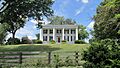
Woodlawn Farm
Woodlawn Farm is at 3789 State Route 41, northwest of Washington Court House in Union Township. It was added to the list on February 13, 1986. It is another important historic farm.
Other Unique Historic Sites
Beyond homes, Fayette County has other interesting places that are important to its history.
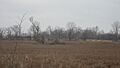
Jackson Mound
The Jackson Mound is located east of State Route 207, about 4 miles north of Pancoastburg in Madison Township. This ancient mound was listed on October 21, 1975. Mounds like this were often built by early Native American cultures.
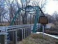
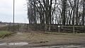
Mark Road Bridge
The Mark Road Bridge crosses Sugar Creek, north of Staunton, in Concord and Union Townships. This historic bridge was recognized on July 26, 1990. Old bridges are important for understanding how people traveled long ago.
Historic Districts and Public Places
Some areas are recognized as historic districts because they contain many important buildings or have a special history.
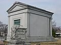
Washington Cemetery Historic District
The Washington Cemetery Historic District is at 1741 Washington Avenue in Washington Court House. It was listed on September 6, 2006. Cemeteries can be historic because of the people buried there or the art on the gravestones.
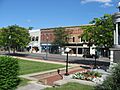
Washington Court House Commercial Historic District
The Washington Court House Commercial Historic District includes the area roughly bounded by North, East, Hinde, and Market Streets in Washington Court House. This district was added on September 12, 1985. It shows what the downtown area looked like in the past.
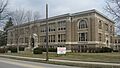
Washington School
The Washington School is at 318 North North Street in Washington Court House. This school building was listed on January 14, 2013. Old school buildings often have many stories to tell about education in the past.
Images for kids
-

William Burnett House
-
Fayette County Courthouse
-
Jackson Mound
-
Judy Chapel
-
Barney Kelley House
-
Jacob Light House
-
Mark Road Bridge
-
William McCafferty Farmhouse
-
Rawlings-Brownell House
-
Robinson-Pavey House
-
Morris Sharp House
-
Edward Smith, Jr., Farm
-
Sollars Farmstead
-
Washington Cemetery Historic District
-
Washington Court House Commercial Historic District
-
Washington School
-
Woodlawn Farm


