
National Register of Historic Places listings in Giles County, Tennessee facts for kids

Hey everyone! Have you ever wondered about really old and special buildings or places in your town or county? Well, in Giles County, Tennessee, there are lots of amazing spots that are so important, they're listed on something called the National Register of Historic Places.
This list helps us keep track of all the cool historic buildings, farms, and areas in Giles County. These places are like treasures because they tell us stories about the past and how people lived a long time ago. When a place is on this list, it means it's really important to our country's history. There are 33 special places in Giles County on this list right now. Some places that were once on the list have been removed for different reasons.
Contents
- What is the National Register of Historic Places?
- Some Cool Historic Places in Giles County
- Bodenham Mill
- Bridgeforth High School
- Brown-Daly-Horne House
- Campbell Chapel African Methodist Episcopal Church
- Church of the Messiah
- First Presbyterian Church of Pulaski
- Austin Hewitt Home
- Lairdland Farm House
- Maplewood Cemetery
- Milky Way Farm
- Olivet United Methodist Church, Parsonage and School
- Original Church of God
- Pisgah United Methodist Church and Cemetery
- Pulaski Courthouse Square Historic District
- Reveille
- George W. Tillery House
- Elisha White House
- Copeland Whitfield House
- Wilkinson-Martin House
- Places No Longer on the List
- Images for kids
What is the National Register of Historic Places?
The National Register of Historic Places is like a special club for buildings, sites, and objects that are important in American history, architecture, archaeology, engineering, or culture. It's managed by the National Park Service, which is part of the United States government.
Why are places listed?
Places get listed because they are unique or have played a big part in history. Maybe a famous person lived there, or an important event happened, or it's a great example of old building styles. Listing a place helps protect it and makes people more aware of its value. It's a way to make sure these important parts of our past are saved for future generations, like you!
Types of Historic Places
When you look at the list, you might see different types of places:
- Individual Properties: These are single buildings, like a historic house or a church.
- Historic Districts: These are areas that have many historic buildings or sites grouped together. Think of a whole old neighborhood or a town square.
Some Cool Historic Places in Giles County
Let's take a closer look at a few of the interesting places in Giles County that are on the National Register. Each one has its own story!
Bodenham Mill

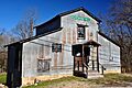
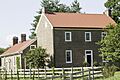
The Bodenham Mill is located near Pulaski, Tennessee. Mills like this one were super important long ago because they helped grind grain into flour. This was a vital part of daily life for communities, as it provided food. The Bodenham Mill reminds us of how people used to get their food ready before modern grocery stores. It was added to the list in 2013.
Bridgeforth High School

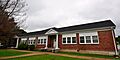
Located in Pulaski, Tennessee, Bridgeforth High School is a significant historic building. Schools are often listed because they represent important parts of community life and education history. This school was added to the National Register in 2006, showing its lasting importance to the area.
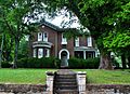
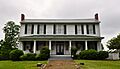
Brown-Daly-Horne House

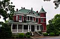
The Brown-Daly-Horne House is a beautiful old home in Pulaski, Tennessee. Historic houses often show us how people lived, what their homes looked like, and the architectural styles popular in different time periods. This house was listed in 1979, preserving its unique history and design.
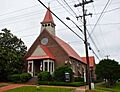
Campbell Chapel African Methodist Episcopal Church
.JPG)
Churches are often very important community centers and hold a lot of history. The Campbell Chapel African Methodist Episcopal Church in Pulaski, Tennessee, is one such place. It was added to the National Register in 2000, recognizing its role in the community's past.
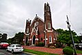
Church of the Messiah

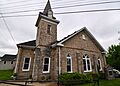
Another historic church in Pulaski, Tennessee, is the Church of the Messiah. This building, listed in 1983, stands as a testament to the community's history and its architectural heritage. Churches often have unique designs and stories connected to the people who built and worshipped in them.
First Presbyterian Church of Pulaski

The First Presbyterian Church of Pulaski, located in Pulaski, Tennessee, is another important religious building on the list. It was recognized in 1983. These old churches are not just places of worship; they are also landmarks that tell us about the growth and development of a town.
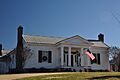
Austin Hewitt Home

The Austin Hewitt Home, found in Pulaski, Tennessee, was added to the National Register in 1984. This house is a great example of the kind of homes built in the area a long time ago. It helps us imagine what life was like for families living there in the past.
Lairdland Farm House

The Lairdland Farm House, located near Brick Church, Tennessee, is a historic farm property. Farms are often listed because they show us how agriculture shaped the region and how people lived off the land. This farm house and its buildings were listed in 1995.
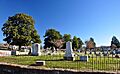
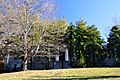
Maplewood Cemetery

Maplewood Cemetery in Pulaski, Tennessee, is not just a burial ground; it's a historic site. Cemeteries can be important because they contain old gravestones and monuments that tell us about the people who lived in the area and the art and history of the time. It was added to the list in 2005.
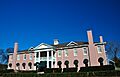
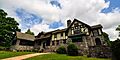
Milky Way Farm

Milky Way Farm, located in Pulaski, Tennessee, is a very unique and large historic property. It was listed in 1984. Farms like this one often have interesting stories about their owners and how they contributed to the local economy and culture. The Manor House is a particularly impressive part of the farm.
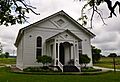
Olivet United Methodist Church, Parsonage and School

This group of buildings in Riversburg, Tennessee, including the church, parsonage (where the minister lived), and school, shows how important these places were to a community. They were listed in 1984, highlighting their role in education and spiritual life.
Original Church of God
.JPG)
The Original Church of God in Pulaski, Tennessee, is another example of a historic church building. Listed in 2006, it represents the religious and social history of the area.
Pisgah United Methodist Church and Cemetery

Located in Pisgah, Tennessee, this church and its cemetery were added to the National Register in 1984. Like Maplewood Cemetery, this site tells stories of the past through its architecture and the people buried there.
Pulaski Courthouse Square Historic District

The Pulaski Courthouse Square Historic District is a whole area in Pulaski, Tennessee, that is considered historic. It includes the old courthouse and many buildings around it. These districts are important because they show how a town center developed over time. It was listed in 1983.
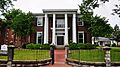
Reveille
.JPG)
Reveille is a historic home in Pulaski, Tennessee, listed in 1994. Homes like Reveille are often preserved because of their unique architecture or their connection to important families or events in the town's history.
George W. Tillery House

The George W. Tillery House, located in Pulaski, Tennessee, was added to the National Register in 1985. This house is another example of the beautiful and historically significant homes that can be found in Giles County.
Elisha White House

The Elisha White House, found near Waco, Tennessee, is a very old home, built around 1811! It was listed in 1983. This house gives us a glimpse into what homes looked like in the early 1800s and how people lived during that time.
Copeland Whitfield House

The Copeland Whitfield House in Pulaski, Tennessee, was listed in 1988. This historic home contributes to the rich architectural history of Giles County.
Wilkinson-Martin House

The Wilkinson-Martin House in Pulaski, Tennessee, was added to the National Register in 2010. This house is a more recent addition to the list, showing that important historic places are still being recognized today.
Places No Longer on the List
Sometimes, a place that was once on the National Register of Historic Places might be removed. This is called "delisted."
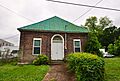
Batte-Brown-Blackburn House

The Batte-Brown-Blackburn House in Pulaski, Tennessee, was listed in 1996 but was delisted in 2009. It is now known as Grissom Colonial Hall and is owned by Martin Methodist College. Places can be delisted for various reasons, such as if they are significantly changed or destroyed, or if they no longer meet the requirements for being historic.
Images for kids
-
Bodenham Mill, a historic building in Pulaski
-
Bridgeforth High School in Pulaski
-
The historic Brown-Daly-Horne House
-
Campbell Chapel African Methodist Episcopal Church
-
The Church of the Messiah in Pulaski
-
First Presbyterian Church of Pulaski
-
The Austin Hewitt House
-
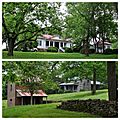
Lairdland Farm House and its surrounding buildings
-
Maplewood Cemetery in Pulaski
-
The Manor House at Milky Way Farm
-
Olivet United Methodist Church, Parsonage and School
-
Original Church of God in Pulaski
-
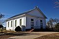
Pisgah United Methodist Church
-
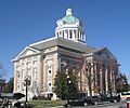
Giles County Tennessee Courthouse, part of the Historic District
-
Reveille, a historic home in Pulaski
-
The George W. Tillery House
-
Elisha White House, built around 1811
-
The Copeland Whitfield House
-
The Wilkinson-Martin House in Pulaski
-
Grissom Colonial Hall, formerly the Batte-Brown-Blackburn House
