
National Register of Historic Places listings in Johnson County, Missouri facts for kids

Have you ever wondered about old buildings and places that are super important to history? In Johnson County, Missouri, there are 22 special spots that are listed on the National Register of Historic Places. This means they are officially recognized for their historical value and are protected.
The National Register of Historic Places is like a special club for buildings, areas, and objects that tell a story about the past. When a place is added to this list, it helps make sure it stays safe and can be enjoyed by future generations. Let's explore some of these cool places in Johnson County!
Contents
- Historic Homes and Farms
- Important Public Buildings
- Other Unique Historic Places
- Knob Noster State Park Features
- Camp Shawnee Historic District
- Montserrat Recreation Demonstration Area Bridge
- Montserrat Recreation Demonstration Area Dam and Spillway
- Montserrat Recreation Demonstration Area Entrance Portal
- Montserrat Recreational Demonstration Area Rock Bath House
- Montserrat Recreational Demonstration Area Warehouse No. 2 and Workshop
- Images for kids
Historic Homes and Farms
Many of the places on the list are old homes and farms. These buildings show us how people lived a long time ago.
John A. Adams Farmstead Historic District
The John A. Adams Farmstead Historic District is a large farm area near Warrensburg, Missouri. It was added to the list in 1994. This farm helps us understand what farming life was like in the past.
Herbert A. and Bettie E. Cress House
The Herbert A. and Bettie E. Cress House is a historic home in Warrensburg, Missouri. It was built a long time ago and was added to the National Register in 1995. Imagine living in a house that's been around for so many years!
Lewis and Sophie Griebel House
Another interesting home is the Lewis and Sophie Griebel House, also in Warrensburg, Missouri. This house became a historic place in 2012. It's a great example of the kind of homes people built back then.
Grover Street Victorian Historic District
The Grover Street Victorian Historic District is a whole street in Warrensburg, Missouri with several historic houses. These homes were built in the Victorian style, which was popular a long time ago. This district was added to the list in 2012.
Important Public Buildings
Some of the most important buildings in Johnson County are also on the National Register. These include courthouses and schools.
Johnson County Courthouses
Did you know Johnson County has two courthouses on the historic list?
- The Johnson County Courthouse on Courthouse Square was added in 1994. This is where important government work happens.
- The other Johnson County Courthouse on Old Public Square was listed even earlier, in 1970. It shows how the county's government has changed over time.
Howard School
The Howard School in Warrensburg, Missouri is a historic school building. It was added to the National Register in 2002. Schools like this are important because they show us how education has developed.
Pleasant View School
Another historic school is the Pleasant View School near Medford, Missouri. It was listed in 1999. These old schoolhouses often have unique designs and stories.
Other Unique Historic Places
Johnson County has a variety of other interesting places that are part of its history.
Garden of Eden Station
The Garden of Eden Station is a unique spot near Warrensburg, Missouri. It was added to the list in 1994. Places like this often have interesting stories about how people traveled or traded goods in the past.
Jones Brothers Mule Barn
The Jones Brothers Mule Barn in Warrensburg, Missouri was listed in 2011. This barn reminds us of a time when mules were very important for farming and transportation.
Magnolia Mills
Magnolia Mills is another historic building in Warrensburg, Missouri, added in 1996. Mills were very important for grinding grain and producing food for communities.
Masonic Temple
The Masonic Temple in Warrensburg, Missouri was listed in 1998. Temples like this were often meeting places for community groups and had special architecture.
Warren Street Methodist Episcopal Church
The Warren Street Methodist Episcopal Church in Warrensburg, Missouri was added to the list in 1996. Churches are often important centers of community life and have beautiful designs.
Knob Noster State Park Features
Knob Noster State Park has several historic features that are on the National Register. These were often built a long time ago as part of park development projects.
Camp Shawnee Historic District
The Camp Shawnee Historic District is a special area within Knob Noster State Park. It was listed in 1985. This district might include old cabins or other structures used for camping.
Montserrat Recreation Demonstration Area Bridge
There's a historic bridge in the park called the Montserrat Recreation Demonstration Area Bridge. It was added to the list in 1985. Bridges are important for travel and often have interesting designs.
Montserrat Recreation Demonstration Area Dam and Spillway
The Montserrat Recreation Demonstration Area Dam and Spillway is another feature in the park, listed in 1985. Dams and spillways help control water and create lakes or ponds.
Montserrat Recreation Demonstration Area Entrance Portal
Even the entrance to the park, the Montserrat Recreation Demonstration Area Entrance Portal, is historic! It was listed in 1985. This shows how much thought went into designing the park.
Montserrat Recreational Demonstration Area Rock Bath House
The Montserrat Recreational Demonstration Area Rock Bath House in the park, listed in 1985, is a building made of rock. It shows the kind of materials and building styles used back then.
Montserrat Recreational Demonstration Area Warehouse No. 2 and Workshop
Finally, the Montserrat Recreational Demonstration Area Warehouse No. 2 and Workshop in the park was also listed in 1985. These buildings were important for storing tools and materials needed to run the park.
Images for kids
-
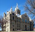
The Johnson County Courthouse in Warrensburg, Missouri.

