
National Register of Historic Places listings in Lancaster County, Nebraska facts for kids

Welcome to Lancaster County, Nebraska! This page is all about special places here that are listed on the National Register of Historic Places. Think of it like a Hall of Fame for buildings, areas, and even old train engines that are important to history. These places are recognized by the United States government because they tell amazing stories about the past.
In Lancaster County, there are over 100 of these special spots! Two of them are even more important and are called National Historic Landmarks. They are like the superstars of historic places. Some other places were once on the list but have been removed, maybe because they changed too much or were no longer there.
Cool Historic Places in Lancaster County
Many buildings and areas in Lancaster County, Nebraska have been saved because they are important parts of history. Let's explore some of them!
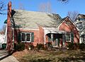
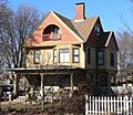
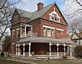
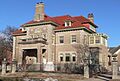
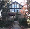
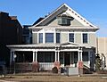
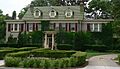
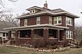
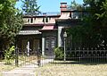
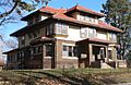
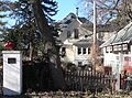
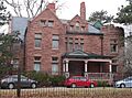
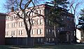
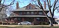
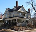
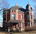
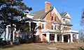
Fairview: William Jennings Bryan's Home
_from_S_1.JPG)
One of the most famous homes in Lincoln, Nebraska is called Fairview. This was the house of William Jennings Bryan, a very important politician who ran for president three times! He was known for his amazing speeches and for fighting for ordinary people. His home, located at 4900 Sumner Street, was listed as a National Historic Landmark in 1966. It's a great example of how a person's home can tell us about their life and times.
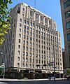
Nebraska State Capitol: A Towering Landmark

The Nebraska State Capitol building is another National Historic Landmark, recognized in 1970. You can find it at 1445 K Street in Lincoln, Nebraska. This isn't just any government building; it's famous for its unique design and tall tower. It's where Nebraska's laws are made and where much of the state's important work happens. Its architecture is truly special and stands out in the city.
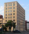
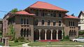
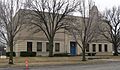
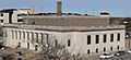
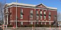
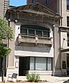
Agricultural Hall: A Fairground Gem
_SW_corner_1.JPG)
At Lincoln's State Fairgrounds, you'll find Agricultural Hall. This building was added to the National Register in 2010. It reminds us of the long history of farming and agriculture in Nebraska, which has always been a very important part of the state's economy and culture.
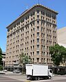
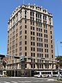
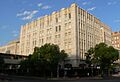
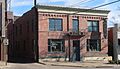
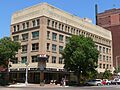
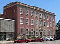
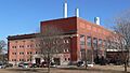
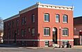
Beatrice Creamery Company Lincoln Plant: Dairy History
_from_SW_1.JPG)
The Beatrice Creamery Company Lincoln Plant at 726 L Street in Lincoln, Nebraska was listed in 2012. This building tells the story of how dairy products were made and distributed a long time ago. It's a piece of Lincoln's industrial past, showing how businesses grew and changed over the years.
Chicago, Burlington & Quincy Steam Locomotive No. 710: A Train from the Past
.JPG)
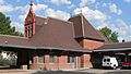
Imagine a giant steam train from the past! The Chicago, Burlington & Quincy Steam Locomotive No. 710 is one of those cool pieces of history. It's located near the junction of 7th and Q Streets in Lincoln, Nebraska and was listed in 1997. This locomotive shows us how people traveled and how goods were moved across the country before modern trains and cars.
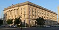
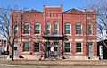
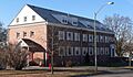
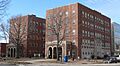
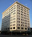
Lincoln City Hall: Where Decisions Are Made
_from_NE_1.JPG)
The City Hall in Lincoln, Nebraska, located at 920 O Street, became a historic place in 1969. This building has been at the center of Lincoln's government for many years. It's where important decisions for the city are made, and it has seen many changes in Lincoln over time.
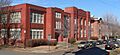
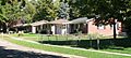
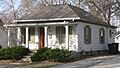
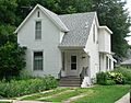
College View Public Library: A Place for Books

The College View Public Library at 3800 S. 48th Street in Lincoln, Nebraska was added to the list in 1984. Libraries are special places where people can learn, read, and connect with their community. This building represents the importance of education and public access to knowledge in Lincoln's history.
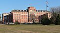
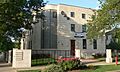
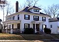
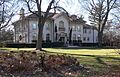
Nebraska Governor's Mansion: Home to Leaders

The Nebraska Governor's Mansion at 1425 H Street in Lincoln, Nebraska was listed in 2008. This beautiful house is where the governor of Nebraska lives and works. It's a symbol of the state's leadership and has been home to many important figures throughout Nebraska's history.
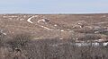
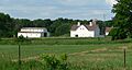
Nine-Mile Prairie: A Natural Treasure

Not all historic places are buildings! Nine-Mile Prairie, located northwest of Huskerville near Lincoln, Nebraska, was listed in 1986. This area is a large piece of untouched prairie land, showing what Nebraska looked like before it was settled. It's important for understanding the natural environment and the history of the Great Plains.
Old Main, Nebraska Wesleyan University: Education's Roots

Old Main at Nebraska Wesleyan University, found at 50th and St. Paul Streets in Lincoln, Nebraska, was recognized in 1975. This building is a key part of the university's history, representing years of education and learning in the community. Many students have passed through its doors, shaping their futures and contributing to society.
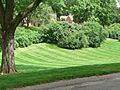
Pioneers Park: A Green Oasis
_columns_1.JPG)
Pioneers Park in Lincoln, Nebraska, located at the junction of W. Van Dorn and Coddington Streets, was listed in 1993. This large park is a beloved green space for the city. It offers a place for recreation, nature, and community gatherings, and its history reflects the growth of Lincoln's public spaces.
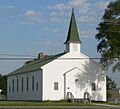
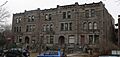
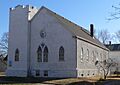
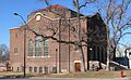
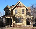
Quinn Chapel African Methodist Episcopal Church and Parsonage: A Community Hub
_from_NW_2.JPG)
The Quinn Chapel African Methodist Episcopal Church and Parsonage at 1225 S. 9th Street in Lincoln, Nebraska was added in 1999. This church has been a very important place for the African American community in Lincoln, serving as a center for worship, social life, and activism for many years. It's a vital part of the city's social history.
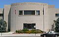
Sheldon Museum of Art: A Place for Creativity
_interior_1.JPG)
The Sheldon Museum of Art at 12th & R Streets, part of the University of Nebraska–Lincoln, was listed in 2013. This museum is a hub for art and culture, showcasing amazing artworks and providing a place for people to explore their creativity and appreciate different forms of expression.
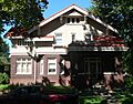
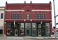
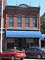
Lincoln Haymarket Historic District: A Busy Past

The Lincoln Haymarket Historic District covers the area generally from 7th to 9th Streets and N to R Streets in Lincoln, Nebraska. It was listed in 2014. This district was once a bustling market area where farmers brought their goods to sell. Today, it's a lively part of the city with shops, restaurants, and entertainment, but its historic buildings still tell the story of its busy past.
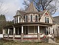
Boulevards Historic District: Beautiful Neighborhoods

The Boulevards Historic District in Lincoln, Nebraska is a large area roughly bounded by South Street, Calvert and High Streets, S. 22nd and S. 24th Streets, Rock Island Trail, and Sheridan Boulevard. It was recognized in 2008. This district is known for its beautiful tree-lined streets and historic homes, showing how neighborhoods were planned and developed in the past to create pleasant living spaces.
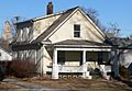
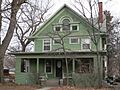
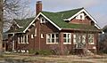
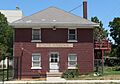
Images for kids
-
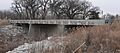
Beal Slough Bridge, no longer standing.
-
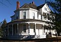
The James A. Beattie House.
-
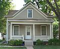
The Jasper Newton Bell House.
-
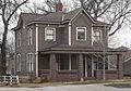
The Guy A. Brown House.
-
A home in the Brownbilt Residential Historic District.
-
The Burckhardt House.
-
The Edgar A. Burnett House.
-
The Burr Block building.
-
The James D. Calhoun House.
-
The William H. Charlton House in Roca.
-
The Christian Record Building.
-
The Eddy-Taylor House.
-
The Federal Trust Building.
-
The William H. Ferguson House.
-
The First National Bank Building.
-
The First State Bank of Bethany.
-
The Frank E. and Emma A. Gillen House.
-
The Gold and Company Store Building.
-
Part of Government Square.
-
A building in the Greek Row Historic District.
-
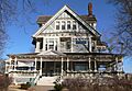
The Harris House.
-
Hayward School.
-
The Helmer-Winnett-White Flats.
-
The Herter Farmstead house in Walton.
-
The W.F. Hitchcok House.
-
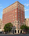
The Hotel Capital.
-
The Aeneas Yates-Charles Hurlbut House.
-
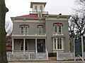
The Thomas P. Kennard House.
-
The Theodore A. Kiesselbach House.
-
The Rose Kirkwood building.
-
The Amel H. Koop House.
-
The Lancaster Block.
-
The Lewis-Syford House.
-
The Lincoln Army Air Field Regimental Chapel.
-
The Lincoln Liberty Life Insurance Building.
-
The main building of the Lincoln Veterans Administration Hospital.
-
The Lincoln YWCA Building.
-
Lyman Terrace.
-
The Masonic Temple.
-
The McWilliams House.
-
A home in the Mount Emerald and Capitol Additions Historic Residential District.
-
The Municipal Lighting and Waterworks Plant.
-

The William L. and Sydney V. Murphy House.
-
Wagon ruts at Spring Creek Prairie.
-
The Nebraska State Historical Society Building.
-
The Nebraska Telephone Company Building.
-
The Old University Library.
-
The Palisade and Regent Apartments.
-
Park Hill.
-
A street in the Park Manor Residential Historic District.
-
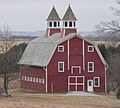
The Peter Peterson Farmstead barn.
-
The Phi Delta Theta Fraternity House.
-
The Phi Kappa Tau Fraternity House.
-
The R.O. Phillips House.
-
The President and Ambassador Apartments.
-
The Quinn Chapel African Methodist Episcopal Church.
-
The Retzlaff Farmstead.
-
The Rock Island Depot.
-
The Nimrod Ross House.
-
The Royer-Williams House.
-
The Ryons-Alexander House.
-
The St. Charles Apartments.
-
The Scottish Rite Temple.
-
Sky Park Manor.
-
A building in the South Bottoms Historic District.
-
The Frank M. Spalding House.
-
The R.O. Stake House.
-
The State Arsenal.
-
The Stuart Building.
-
The Temple of Congregation B'nai Jeshurun.
-
The Terminal Building.
-
The John M. Thayer House.
-
The Tifereth Israel Synagogue (now apartments).
-
The William H. Tyler House.
-
A home in the University Place Historic Residential District.
-
The Veith Building.
-
The Albert Watkins House.
-
The Wesleyan Hospital and Nurses Training School.
-
Whitehall.
-
The Woods Brothers Building.
-
The Frank and Nelle Cochrane Woods House.
-
Woodsshire Residential Historic District.
-
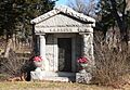
A mausoleum in Wyuka Cemetery.
-
The John H. and Christina Yost House.
-
The Arthur C. Ziemer House.

_from_SW_1.JPG)
_from_S_1.JPG)


_from_SW_1.JPG)
_from_S_1.JPG)
_from_SW_1.JPG)
_from_SE_2.JPG)

_from_SE_3.JPG)

_from_SW_1.JPG)
_from_SW_1.JPG)
_from_NW_1.JPG)

_from_N_1.JPG)
_from_NE_3.JPG)
_from_NE_1.JPG)
_from_SE_1.JPG)
_from_S_1.JPG)
_from_SE_2.JPG)


.JPG)
_from_NE_2.JPG)
_from_W_1.JPG)

_from_SE_2.JPG)


_from_N_1.JPG)
_from_W_2.JPG)


_from_SW_1.JPG)


_from_SW_1.JPG)


_from_NW_1.JPG)

_1035_from_E_1.JPG)
_from_E_1.JPG)


_from_NE_1.JPG)


_4.JPG)


_from_NE_1.JPG)
_from_NE_1.JPG)


_from_E_1.JPG)

_from_S_1.JPG)
_from_NW_2.JPG)
_from_SE_1.JPG)
_from_NE_1.JPG)
_from_NW_1.JPG)

_from_W_1.JPG)

_from_S_1.JPG)
_from_S_2.JPG)

_from_SE_1.JPG)
_from_NW_1.JPG)
_from_NE_1.JPG)


_from_SW_2.JPG)

Places No Longer on the List
Sometimes, a historic place might be removed from the National Register. This can happen if the building is changed too much, or if it's unfortunately destroyed. Here are a few examples from Lancaster County:
- Ehlers Round Barn: This unique round barn near Roca, Nebraska was listed in 1995 but was sadly destroyed in a snowstorm in 2012. It was removed from the list in 2013.
- Olive Branch Bridge: This bridge near Sprague, Nebraska was listed in 1992 but is no longer standing. It was removed in 2013.
These examples remind us that historic places need care and protection to keep their stories alive for future generations.
