
National Register of Historic Places listings in Laramie County, Wyoming facts for kids

Laramie County in Wyoming is home to many amazing places that are part of the National Register of Historic Places. This special list helps protect buildings, sites, and objects that are important to American history. Think of it like a hall of fame for historic spots! In Laramie County, there are 55 places on this list. Three of them are even more special and are called National Historic Landmarks, which means they are super important to the whole country.
Contents
Cool Historic Buildings in Cheyenne
Cheyenne, the capital city, has many historic buildings. These places tell stories about the past.
Important Public Buildings
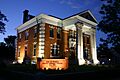
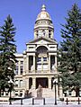
- Wyoming State Capitol: This beautiful building is where Wyoming's laws are made. It was listed as a National Historic Landmark in 1973. It's a grand building where important decisions for the state happen.
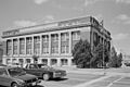
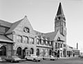
- Union Pacific Railroad Depot: Located at 121 W. 15th St., this old train station is also a National Historic Landmark. It was a very busy place when trains were the main way to travel and move goods. It was added to the list in 1973.
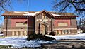
- City and County Building: Found at 19th St. and Carey Ave., this building was listed in 1978. It's where local government business takes place.
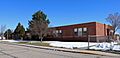
- Federal Office Building-Cheyenne: This building at 308 W. 21st St. was listed in 2000. It's another example of important government architecture.
- Masonic Temple: At 1820 Capitol Ave., this building was listed in 1984. Masonic Temples are often known for their unique and grand designs.
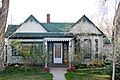
Historic Homes and Theaters
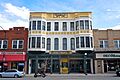
- Atlas Theatre: This theater at 213 W. 16th St. was listed in 1973. Imagine all the shows and movies people have watched there over the years!
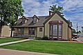
- Moreton Frewen House: This historic home at 506 E. 23rd St. was listed in 1975. It belonged to Moreton Frewen, an interesting figure from the past.
- Governor's Mansion: The old Governor's Mansion at 300 E. 21st St. was listed in 1969. This is where Wyoming's governors used to live and work.
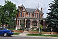
- Nagle Warren Mansion: Located at 222 E. 17th St., this grand house was listed in 1976. It's a beautiful example of old architecture.
- Whipple-Lacey House: This house at 300 E. 17th St. was listed in 1980. Many historic homes in Cheyenne show how people lived long ago.
- William Sturgis House: At 821 E. 17th St., this house was listed in 1982. It's another example of a well-preserved historic home.
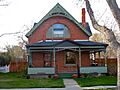
- Charles L. Beatty House: This house at 2320 Capitol Ave. was listed in 1990.
Old Churches
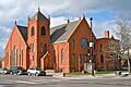
- First United Methodist Church: This church at the corner of 18th St. and Central Ave. was listed in 1975.
- St. Mark's Episcopal Church: Located at 1908 Central Ave., this church was listed in 1970.
- St. Mary's Catholic Cathedral: This beautiful cathedral at 2107 Capitol Ave. was listed in 1974. These churches are not just places of worship but also important parts of the city's history and architecture.
Schools with History
Several old school buildings in Cheyenne are also on the National Register. They show how education has changed over time.
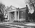
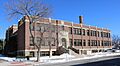
- Cheyenne High School: The building at 2810 House Ave. was listed in 2005. Imagine all the students who walked those halls!
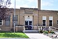
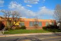
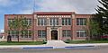
- Churchill Public School: This school at 510 W. 29th St. was listed in 2005.
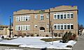
- Deming School: Located at 715 W. 5th Ave., this school was listed in 2005.
- Mabel Fincher School: This school at 2201 Morrie Ave. was listed in 2005.
- Hebard Public School: At 413 Seymour Ave., this school was listed in 2005.
- Johnson Public School: This school at 711 Warren Ave. was listed in 2005.
- Lulu McCormick Junior High School: Found at 2001 Capitol Ave., this junior high was listed in 2005.
- Park Addition School: This school at 1100 Richardson Court was listed in 2005.
- Pine Bluffs High School: This school in Pine Bluffs, at the junction of 7th and Elm Sts., was listed in 1996.
These schools are important because they represent the history of education in Laramie County.
Historic Districts
Some areas are listed as "historic districts" because they have many important buildings together.
- Capitol North Historic District: This area is roughly bounded by E. 29th and E. 25th Sts. and Warren and Pioneer Aves. It was listed in 1980.
- Cheyenne South Side Historic District: This district is roughly bounded by Warren Ave., Russell Ave., E. 10th St., and E. 5th St. It was listed in 2006.
- Downtown Cheyenne Historic District: This large area in downtown Cheyenne was listed in 1978. It includes many important buildings that make up the heart of the city.
- Lakeview Historic District: This area is roughly bounded by 27th, Seymour, Maxwell, and Warren. It was listed in 1996.
- Rainsford Historic District: This district is roughly bounded by Morrie, 22nd, Warren, and 17th Sts. It was listed in 1984.
Other Interesting Historic Places
- Fort David A. Russell: Located on the western side of Cheyenne, this fort was listed as a National Historic Landmark in 1969. It played a big role in military history.
- Boeing/United Airlines Terminal Building, Hangar and Fountain: This historic airport building at 200 E. 8th Ave. was listed in 1985. It shows the early days of air travel.
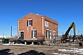
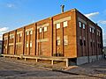
- Cheyenne Flour Milling Company: This old mill at 810-814 W. 23rd St. was listed in 2003. It reminds us of how food was produced long ago.
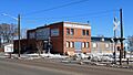
- Continental Oil Company: This building at 801 W. 19th St. was listed in 2003.
- Laramie County Milk Producers Cooperative Association: This building at 1122 W. 23rd St. was listed in 2003.
- McCord-Brady Company: Located at 1506 Thomes Ave., this building was listed in 2003.
- Texas Oil Company: This building at 1122 W. 23rd St. was listed in 2003.
- Wyoming Fuel Company: At 720 W. 18th St., this building was listed in 2003. These industrial buildings show the history of business and industry in the area.
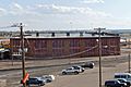
- Union Pacific Roundhouse, Turntable and Machine Shop: These important railroad structures at 121 W. 15th St. were listed in 1992. They were vital for maintaining trains.
- Hynds Lodge: This lodge is located in Curt Gowdy State Park and was listed in 1984. It's a great example of a historic outdoor recreation spot.
- Remount Ranch: This ranch, about 1 mile south of U.S. Route 80, was listed in 1990. Ranches are a big part of Wyoming's history.
Images for kids
-
The Atlas Theatre in Cheyenne.
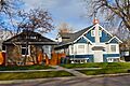
-
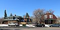
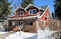
Baxter Ranch Headquarters Buildings.
-
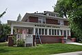
The Charles L. Beatty House.
-
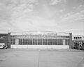
The Boeing/United Airlines Terminal Building and Hangar.
-
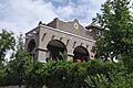
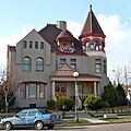
The unique Castle on 19th Street.
-
The Cheyenne Flour Milling Company building.
-
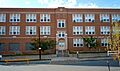
Cheyenne High School.
-
Churchill Public School.
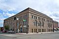
-
The City and County Building.
-
The Continental Oil Company building.
-
The Crook House.
-
Deming School.
-
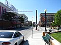
A view of Downtown Cheyenne.
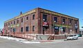
-
The Dubois Block.
-
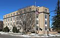
The Federal Office Building in Cheyenne.
-
Mabel Fincher School.
-
First United Methodist Church.
-
Fort David A. Russell.
-
The Moreton Frewen House.
-
The Historic Governor's Mansion.
-
Hebard Public School.
-
Johnson Public School.
-
Keefe Row.
-
The Ferdinand Lafrentz House.
-
A building in the Lakeview Historic District.
-
Laramie County Milk Producers Cooperative Association.
-
The Masonic Temple in Cheyenne.
-
The McCord-Brady Company building.
-
Lulu McCormick Junior High School.
-
The Nagle Warren Mansion.
-
Park Addition School.
-
Pine Bluffs High School.
-

A building in the Rainsford Historic District.
-
Remount Ranch.
-
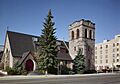
St. Mark's Episcopal Church.
-
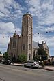
St. Mary's Catholic Cathedral.
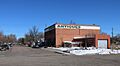
-
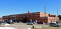
Storey Gymnasium.
-

The William Sturgis House.
-
The Texas Oil Company building.
-
The Union Pacific Railroad Depot.
-
The Union Pacific Roundhouse.
-

The Van Tassell Carriage Barn.
-
The Whipple-Lacey House.
-
The Wyoming Fuel Company building.
-
The Wyoming State Capitol.


.JPG)


.JPG)
.JPG)


.jpg)


.JPG)


.jpg)


