
National Register of Historic Places listings in Lawrence County, Mississippi facts for kids

Have you ever wondered about old buildings or special places in your town? Some places are so important that they are added to a special list called the National Register of Historic Places. This list helps protect and celebrate buildings, sites, and objects that are important to American history, architecture, archaeology, engineering, or culture.
In Lawrence County, Mississippi, there are many amazing places that have been added to this important list. These places tell stories about the past, showing us how people lived, worked, and built things long ago. Let's explore some of these cool historic spots!
Contents
What is the National Register of Historic Places?
The National Register of Historic Places is like a hall of fame for historic sites across the United States. It's managed by the National Park Service, which is part of the U.S. government. When a place is added to this list, it means it's recognized as being very special and worth preserving for future generations.
Why are places listed?
Places get listed for many reasons. Maybe a building is a great example of an old style of architecture. Perhaps an event that changed history happened there. Sometimes, a place is important because of someone famous who lived or worked there. Listing a place helps people understand its value and encourages its protection.
Historic Places in Lawrence County
Lawrence County, Mississippi, is home to 31 different properties and districts on the National Register. These range from old houses to bridges and even ancient sites. Each one has a unique story to tell about the county's past.
Old Homes with History
Many of the places on the list in Lawrence County are historic homes. These houses often show us how people lived many years ago. They might have special designs or be connected to important families.
- Armstrong-Lee House: This house, located near Monticello, was added to the list in 1980. It's a great example of the kind of homes built in the area a long time ago.
- Longino House: Found on Caswell Street in Monticello, the Longino House was listed in 1972. It's one of the older listings in the county, showing its long-recognized importance.
- June and Nora Thompson House: This home near New Hebron was added more recently in 2005. It represents a different time period and style, adding to the variety of historic homes.
Important Public Buildings
Some buildings are important because they served the community. They might have been places where laws were made or where people gathered for education.
- Lawrence County Courthouse: Located in Monticello, this courthouse is a central part of the county's history. It was listed in 1993 and is where many important decisions for the county have been made over the years.
- Monticello Consolidated School: This old school building on East Broad Street in Monticello was added to the list in 1991. It reminds us of how education has changed and grown in the area.
Bridges and Transportation
Bridges and old transportation hubs are also important. They show how people and goods moved around the county.
- Bahala Creek Bridge: This bridge, southwest of Oma, was listed in 1988. Old bridges are often amazing examples of engineering from the past.
- New Orleans Great Northern Railroad Depot: This old train station in Monticello was listed in 1995. Train depots were once busy centers where people traveled and goods were shipped. It shows the history of railroads in the area.
Ancient Sites
Not all historic places are buildings. Some are ancient sites that tell us about people who lived in the area thousands of years ago. These are often archaeological sites where experts can learn about early cultures.
- George Mound (22LW591): This site near Oma was listed in 1987. Mounds are often ancient earthworks built by Native American cultures.
- Lowe-Steen Site (22LW511): Another important archaeological site near Monticello, listed in 1987.
- Mill Creek Site: Also near Monticello, this site was listed in 1978. These sites help us understand the very first people who lived in Lawrence County.
Images for kids
-
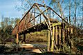
The historic Bahala Creek Bridge.
-
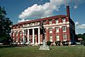
The Lawrence County Courthouse in Monticello.
-
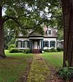
The Longino House, a historic home in Monticello.
-
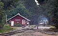
The New Orleans Great Northern Railroad Depot.


