
National Register of Historic Places listings in Lee County, Kentucky facts for kids

Have you ever wondered about the oldest and most special places in your community? In Lee County, Kentucky, there are some really cool spots that are officially recognized for their history! These places are listed on the National Register of Historic Places. This is like a special list kept by the United States government. It helps protect important buildings, sites, and objects that tell us about the past.
When a place is on this list, it means it's worth saving for future generations. It could be an old school, a historic church, or even ancient rock carvings made by people long ago. Lee County has 9 of these amazing places. Let's explore some of them!
Contents
Historic Treasures of Lee County
These are some of the special places in Lee County that are listed on the National Register of Historic Places. Each one has a unique story to tell about the area's past.
Ancient Rock Art and Shelters
Lee County is home to several very old sites with special rock art. These are called petroglyphs. They are designs carved or pecked into rock surfaces by early people. These sites are kept secret to protect them, so their exact locations are not shared.
- Bear Track Petroglyphs (15LE112)
- Location: Near Mt. Olive
- Listed: September 8, 1989
- These ancient carvings give us clues about the people who lived here many, many years ago.
- Big Sinking Creek Turtle Rock Petroglyphs
- Location: Near Mt. Olive
- Listed: January 2, 1992
- This site features more fascinating rock carvings, including one that looks like a turtle!
- Old Landing Petroglyphs (15LE113)
- Location: Near Old Landing
- Listed: September 8, 1989
- Another important site with ancient rock art, showing the rich history of early inhabitants.
- Perdue Petroglyphs (15LE111)
- Location: Near Fixer
- Listed: September 8, 1989
- These petroglyphs are also a valuable link to the past, showing the artistic and cultural practices of early people.
Some historic places are also natural rock shelters that early people used for protection.
- Cold Oak Shelter (15LE50)
- Location: Near Zachariah
- Listed: August 14, 1996
- This natural rock shelter was likely used by ancient people for protection from the weather.
- Pine Crest Shelter (15LE70)
- Location: Near Zachariah
- Listed: August 14, 1996
- Another significant rock shelter, showing how early communities lived and survived in the area.
Historic Buildings in Beattyville
The town of Beattyville has several historic buildings that are important to its community's story.
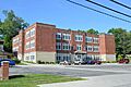
- Beattyville Grade School
- Address: 58 East Center Street, Beattyville
- Listed: February 7, 2008
- This old school building has been a place of learning for many generations of students in Beattyville. It's a reminder of how education has grown in the area.
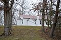
- St. Therese Church
- Address: 4375 Kentucky Route 399, Beattyville
- Listed: February 28, 2012
- This church has served its community for many years. It's a beautiful example of local architecture and a place of worship.
- St. Thomas Episcopal Church
- Address: Hill Street, Beattyville
- Listed: April 21, 1976
- Another historic church in Beattyville, St. Thomas Episcopal Church has been an important part of the town's spiritual and social life for a long time.
Images for kids
-
The historic Beattyville Grade School building.
-
St. Therese Church, a landmark in Lee County.
-

St. Thomas Episcopal Church in Beattyville.


