
National Register of Historic Places listings in Lumpkin County, Georgia facts for kids
Lumpkin County, Georgia, is home to many special places listed on the National Register of Historic Places. This list includes buildings, areas, and sites that are important to the history of the United States. These places are recognized for their unique stories and how they help us understand the past.
Historic Places in Lumpkin County
Lumpkin County has several fascinating sites that tell tales of its rich history, especially about the Georgia Gold Rush.
Calhoun Mine: A Golden Past
The Calhoun Mine is a very important site, known as a National Historic Landmark. It's located about three miles south of Dahlonega. This mine played a big role in the Georgia Gold Rush of the 1800s. It was one of the first places where gold was found in Georgia, leading to a huge rush of people hoping to strike it rich.

Dahlonega Gold Museum: Stories of Gold
The Dahlonega Gold Museum Historic Site is a must-see. It's located in the old Lumpkin County Courthouse right in Dahlonega. This museum tells the exciting story of the Georgia Gold Rush. You can learn how gold was discovered and how it changed the area. The building itself is historic, built in 1836. It's one of Georgia's oldest courthouses.

Dahlonega Consolidated Gold Mine: Explore Underground
Northeast of Dahlonega is the Dahlonega Consolidated Gold Mine. This was once one of the largest gold mines east of the Mississippi River. Today, visitors can explore parts of the mine and learn about the hard work of gold miners. It's a great way to imagine what life was like during the gold rush.
.JPG)
Blood Mountain Trail Shelter: A Mountain Retreat
High up in the Blood Mountain Wilderness Area is the Blood Mountain Trail Shelter. This shelter was built in 1934 by the Civilian Conservation Corps (CCC). The CCC was a program during the Great Depression that put young men to work building parks and trails. The shelter is a popular stop for hikers on the famous Appalachian Trail. It offers a safe place to rest and enjoy the beautiful mountain views.

Holly Theatre: A Place for Shows
The Holly Theatre is located on West Main Street in Dahlonega. This historic theater has been a center for entertainment in the community for many years. It hosts plays, concerts, and other performances. It's a great example of how old buildings can be brought back to life for new generations to enjoy.

Price Memorial Hall: A Golden Dome
Price Memorial Hall is a striking building on College Avenue in Dahlonega. It's part of the University of North Georgia. What makes it special is its golden dome. This dome is covered with real gold leaf, mined right from the local area. It's a reminder of Dahlonega's gold mining past and a beautiful landmark on the campus.

Lumpkin County Jail: A Look Back
The Lumpkin County Jail on Clarksville Street in Dahlonega is another historic site. Built in 1880, it served as the county jail for many years. It's an interesting example of old jail architecture and gives us a glimpse into the justice system of the past.

Images for kids
-
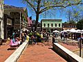
The Dahlonega Commercial Historic District.
-
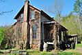
The historic Daniel M. Davis House.
-
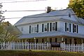
The Fields Place-Vickery House.
-
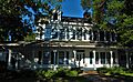
The historic Seven Oaks home.

.JPG)


