
National Register of Historic Places listings in Manhattan on islands facts for kids
This article lists important historic places and areas on islands near Manhattan in New York City. These places are special because they are listed on the National Register of Historic Places. This means they are recognized for their history and importance to the United States.
You can find these historic spots on islands like Governors Island, Roosevelt Island, Liberty Island, and Ellis Island. Even though these islands are not Manhattan Island itself, they are still part of New York County, New York.
Contents
Historic Places on New York County Islands
This section lists many interesting buildings and sites found on the islands that are part of New York County. Each place has a unique story and history.
Governors Island Landmarks
Governors Island is a special island in New York Harbor. It has been used for military purposes for a long time. Now, it is a public park and a place to learn about history.
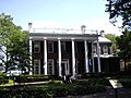
Admiral's House
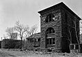
The Admiral's House is on Nolan Park on Governors Island. It was built in 1843. This house was used by the top military officers who commanded the Army and Coast Guard units stationed on the island. It was added to the National Register of Historic Places in 1972.
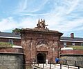
Block House
The Block House is a small, strong building on Governors Island. It was used as a military prison. It is located on Nolan Park on Barry Road. This historic building was listed in 1972.
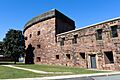
Castle Williams
Castle Williams is a large, round fort made of red sandstone. It was built in the early 1800s to help protect New York City from attacks by ships. It sits on the northwest side of Governors Island. Today, it is part of the Governors Island National Monument. It became a historic place in 1972.
Fort Jay
Fort Jay is another old fort on Governors Island. It is a star-shaped fort built in 1794. Its main job was to defend New York Harbor from enemies. Like Castle Williams, it is now part of the Governors Island National Monument. It was added to the National Register in 1974.
Governor's House
The Governor's House is a historic home on Governors Island. It is known as Building 2 on Andes Road. This house has a rich history on the island. It was recognized as a historic place in 1973.
Governors Island as a Historic District
The entire Governors Island is considered a very important historic place. It is a 172-acre island that has grown over time. It has been used by different military forces throughout history. Now, it is a popular spot for many activities and learning. The island was listed as a National Historic Landmark in 1985.
Roosevelt Island Landmarks
Roosevelt Island is a long, narrow island in the East River. It was once called Welfare Island. It has a unique history, including being home to hospitals and asylums.
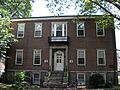
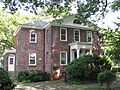
Blackwell House
The Blackwell House is a very old building on Roosevelt Island, located at 501 Main Street. It was built in 1796 by a family member of the first English owner of the island. This house is one of the oldest buildings on the island. It was listed as historic in 1972.
Chapel of the Good Shepherd
The Chapel of the Good Shepherd is a beautiful old church on Roosevelt Island at 543 Main Street. It was designed by a famous architect named Frederick Clarke Withers. Today, it is known as the Good Shepherd Community Ecumenical Center. It became a historic place in 1972.
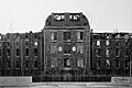
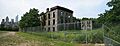
City Hospital
The City Hospital on Roosevelt Island was built in 1861 by James Renwick, Jr.. It was created to replace an older hospital. This building was an important part of the island's history as a medical center. The hospital was demolished in 1994, but its history is still remembered. It was listed in 1972.
Blackwell Island Lighthouse
The Blackwell Island Lighthouse is an old lighthouse at the very north end of Roosevelt Island. It was built in 1872. This lighthouse helped guide ships in the East River. It is a well-known landmark on the island and was listed in 1972.
The Octagon
The Octagon is a unique building on Roosevelt Island at 888 Main Street. It was originally the main entrance to the New York City Lunatic Asylum, which opened in 1841. The building was designed by Alexander Jackson Davis. It was listed as historic in 1972.
Smallpox Hospital
The Smallpox Hospital on Roosevelt Island was designed by architect James Renwick Jr. It opened in 1856 and had 100 beds. At that time, the island was known as Blackwell's Island. The ruins of this hospital have been carefully kept and protected. It became a historic place in 1972.
Strecker Memorial Laboratory
The Strecker Memorial Laboratory was built in 1892. It was designed by architects Frederick Clarke Withers and Walter Dickson. This building was used as a laboratory for City Hospital. It was very important because it was "the first institution in the nation for pathological and bacteriological research." It was listed as historic in 1972.
Liberty Island Landmarks
Liberty Island is a small island in New York Harbor, famous for one of the most iconic statues in the world.
Statue of Liberty
The Statue of Liberty Enlightening the World is a world-famous statue on Liberty Island. It is a symbol of freedom and democracy. This iconic statue was added to the National Register of Historic Places in 2017.
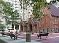
Statue of Liberty National Monument
The Statue of Liberty National Monument includes both Liberty Island and Ellis Island. It features the Statue of Liberty and the former immigration station at Ellis Island, which includes the Ellis Island Immigrant Hospital. This entire area is a National Monument and was listed in 1966.
Images for kids
-
The Admiral's House on Governors Island.
-

The historic Blackwell House on Roosevelt Island.
-
The Block House, a former military prison on Governors Island.
-
Castle Williams, a circular fort on Governors Island.
-
The Chapel of the Good Shepherd on Roosevelt Island.
-
The former City Hospital on Roosevelt Island.
-
Fort Jay, an old star fort on Governors Island.
-
The Governor's House on Governors Island.
-
A view of Governors Island from above.
-
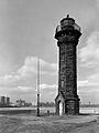
The Blackwell Island Lighthouse at the north end of Roosevelt Island.
-

The Octagon building on Roosevelt Island.
-
The preserved ruins of the Smallpox Hospital on Roosevelt Island.
-
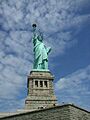
The iconic Statue of Liberty on Liberty Island.
-
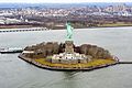
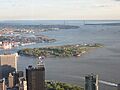
Liberty Island and Ellis Island, part of the National Monument.
-
The Strecker Memorial Laboratory on Roosevelt Island.

.jpg)


.jpg)

.jpg)

.jpg)


.jpg)
See also
 In Spanish: Anexo:Registro Nacional de Lugares Históricos en Manhattan (islas) para niños
