
National Register of Historic Places listings in Meade County, South Dakota facts for kids

Have you ever wondered about the special places in your community that tell a story about the past? In Meade County, South Dakota, there are many such spots! These places are listed on the National Register of Historic Places. This is like a special list kept by the United States government. It helps protect buildings, sites, and objects that are important to history, architecture, archaeology, engineering, or culture.
Meade County has 31 places on this list. One of them is even a National Historic Landmark, which means it's super important to the whole country! You can even see some of these places on a map if their exact location is shared. Let's explore some of these cool historic spots!
Contents
- What is the National Register of Historic Places?
- Cool Historic Places in Meade County
- Bear Butte: A Sacred Mountain
- Fort Meade: A Military History Hub
- Erskine School: Learning from the Past
- Stephen and Maria Graf House: A Historic Home
- H O Ranch Log House: Life on the Prairie
- Minneapolis Brewing Company Beer Warehouse: A Taste of History
- Municipal Building-City Hall: Community Center Then and Now
- Sturgis Commercial Block: Downtown History
- Sturgis High School: A Place for Education
- Annie Tallent House: A Pioneer's Home
- What Happens When a Place is Delisted?
- Images for kids
What is the National Register of Historic Places?
The National Register of Historic Places, or NRHP, is the official list of places in the United States that are worth saving. It's like a hall of fame for historic sites! When a place is added to this list, it means it's recognized for its unique history or special design.
Why are places listed?
Places get listed for many reasons. Maybe a famous person lived there, or an important event happened there. Sometimes, a building is listed because it's a great example of an old style of architecture. Listing a place helps people understand its value and encourages them to protect it for future generations.
National Historic Landmarks
A National Historic Landmark (NHL) is an extra special place. It's like the "best of the best" on the National Register. These sites are so important that they are recognized for their significance to the entire nation's history. Meade County is proud to have one of these!
Cool Historic Places in Meade County
Meade County is full of interesting places that have been around for a long time. Let's look at some of the most exciting ones on the National Register.
Bear Butte: A Sacred Mountain

One of the most important places in Meade County, and a National Historic Landmark, is Bear Butte. This tall, cone-shaped mountain is northeast of Sturgis. It's a very sacred spot for many Native American tribes, like the Lakota and Cheyenne. For hundreds of years, people have gone to Bear Butte for prayer, ceremonies, and vision quests. It's a place of peace and spiritual meaning. It was added to the National Register in 1973.
Fort Meade: A Military History Hub

East of Sturgis, you'll find the Fort Meade District. This used to be a United States Army post. It was built in 1878 to help keep peace in the area during the time of settlement. Many famous military figures were stationed here. The fort played a big role in the history of the Black Hills region. Today, some of the old buildings are still standing, reminding us of its past. It became a historic district in 1973.
Erskine School: Learning from the Past
The Erskine School in Sturgis is another historic spot. This old school building, located on Sherman Street, was added to the National Register in 1984. It reminds us of how education has changed over the years and the importance of schools in a community's history.
Stephen and Maria Graf House: A Historic Home
In Sturgis, at 1233 Main Street, stands the Stephen and Maria Graf House. This house was built a long time ago and tells a story about the families who lived there. It was recognized for its historical value in 2002.
H O Ranch Log House: Life on the Prairie
Imagine living on a ranch many years ago! The H O Ranch Log House, located near Marcus, gives us a peek into that life. This log house was added to the National Register in 1990. It shows us how early settlers built their homes and lived on the vast South Dakota prairie.
Minneapolis Brewing Company Beer Warehouse: A Taste of History
In the town of Faith, there's an old building that used to be the Minneapolis Brewing Company Beer Warehouse. Even though it was a warehouse for beer, it's important because it shows how businesses operated and how goods were distributed in the past. It was listed in 2001.
Municipal Building-City Hall: Community Center Then and Now
Also in Faith, the Municipal Building-City Hall is a historic site. This building, designed by architect U.L. Freed, was once the main place for town meetings and government. It was added to the National Register in 2000. Today, it's the Municipal Bar/Liquor Store, showing how buildings can change their use over time while still holding their history.
Sturgis Commercial Block: Downtown History
The heart of downtown Sturgis, specifically the buildings from 1000-1028 Main Street, is known as the Sturgis Commercial Block. This area shows what the main street of a busy town looked like many years ago. These buildings housed shops and businesses that were important to the community's growth. It became a historic district in 1975.
Sturgis High School: A Place for Education
The building known as Sturgis High School at 1425 Cedar Street is also on the list. This school has seen many students pass through its doors over the years. It was listed in 2000, recognizing its role in the community's education.
Annie Tallent House: A Pioneer's Home

The Annie Tallent House in Sturgis is named after a very interesting person. Annie Tallent was one of the first non-Native American women to enter the Black Hills during the gold rush. Her house, located at 1603 Main Street, was added to the National Register in 1976. It's a reminder of the brave pioneers who helped settle the area.
What Happens When a Place is Delisted?
Sometimes, a historic place can be removed from the National Register. This is called "delisted."
Why do places get delisted?
Places are usually delisted if they are destroyed, like by a fire or a storm. They might also be delisted if they are changed so much that they no longer look like they did historically. For example, a bridge in Meade County, the South Dakota Dept. of Transportation Bridge No. 47-215-363, was delisted in 1999. Another example is the Poker Alice Tubbs House, which was delisted in 1990. This means it no longer met the requirements to stay on the list.
It's important to remember that even if a place is delisted, its history is still a part of Meade County's story!
Images for kids
-
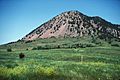
Bear Butte is a very important and sacred place for many Native American tribes.
-
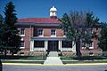
Fort Meade was an important military post in South Dakota's history.
-
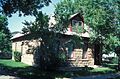
The Annie Tallent House in Sturgis.
