
National Register of Historic Places listings in Montgomery County, Ohio facts for kids

This article is about special places in Montgomery County, Ohio, United States, that are listed on the National Register of Historic Places. Think of this register as an official list of buildings, sites, and objects that are important to American history, architecture, archaeology, engineering, or culture. When a place is on this list, it means it's recognized for its historical value and efforts are made to protect it.
You can even see many of these places on an online map if their exact location coordinates are shared.
Montgomery County has 152 places listed on the National Register. Seven of these are even more special and are called National Historic Landmarks. Most of these, 110 to be exact, are in the city of Dayton. Those are listed in a separate article. This list focuses on the historic places found outside of Dayton. Interestingly, one place, the Miami Valley Golf Course and Clubhouse, is so big it's partly in Dayton and partly outside, so it appears on both lists! Also, two places used to be on the list but have since been removed.
Contents
What is the National Register of Historic Places?
The National Register of Historic Places is the official list of the United States government's historic places. It's like a hall of fame for buildings, sites, and objects that tell important stories about our past. Being on this list helps to preserve these places for future generations. It also means they might get special funding or protection from certain projects.
Historic Places in Montgomery County, Ohio
Dayton's Historic Spots
The city of Dayton has many historic places, including some National Historic Landmarks. You can find out more about them in a separate, detailed list.
Exploring Historic Sites Outside Dayton
Let's explore some of the interesting historic places in Montgomery County that are located outside of Dayton. These places include old homes, churches, farms, and even ancient mounds!
Historic Homes and Farms
Many of the listings are old homes and farms that show how people lived in the past.
- The Arnold Homestead is a historic farm north of Dayton. It was added to the list in 1977.
- The Aullwood House and Garden is a beautiful property northwest of Dayton. It became a historic listing in 1999.
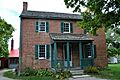
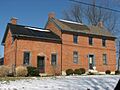
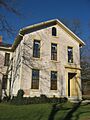
- The Ausenbaugh-McElhenny House in Huber Heights is another old home recognized for its history since 1975.
- The George Bixler Farm in Perry Township was listed in 2002. It gives us a peek into farming life long ago.
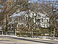
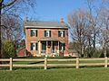
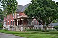
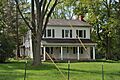
- The Robert Bradford House in Washington Township, listed in 1979, is another example of early homes in the area.
- The Erma Bombeck House in Centerville, listed in 2015, was home to a famous American humorist and writer.
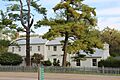
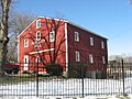
- Deerwood Farm in Butler Township, listed in 1975, is another significant farm property.
- The Joseph Flory House northwest of Clayton was added to the register in 1978.
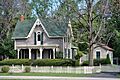
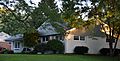
- Fox Hollow in Washington Township, listed in 2006, is a notable historic residence.
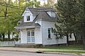
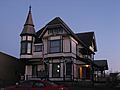
- The Ethol Kellog House near Centerville, listed in 1976, shows us more about the area's past.
- The Koehne-Poast Farm near Germantown was listed in 1977.
- The Krug House in Union, listed in 1992, is another example of historic architecture.
- The Long-Mueller House and the Long-Romspert House, both in Kettering and Oakwood respectively, are also on the list, showing different styles of homes from the past.
- The Samuel Martindale House northeast of Englewood was listed in 1978.
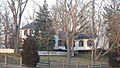
- Normandy Farms northwest of Centerville, listed in 1983, is another historic farm property.
- The Pease Homestead northwest of Centerville, listed in 1980, adds to the collection of historic farms.
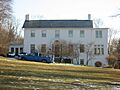
- The David Rohr Mansion and Carriage House in Germantown, listed in 1978, is a grand example of historic homes.
- The Adam Schantz, Sr., House in Oakwood, listed in 1980, is another important historic residence.
- The Schuter Carpenter Shop and House east of West Carrollton, listed in 1980, shows a combination of living and working spaces from the past.
- Skywood Farms northwest of Centerville, listed in 1996, is another historic farm.
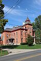
- The Samuel Spitler House in Brookville, listed in 1973, was designed by a famous architect named George Franklin Barber.
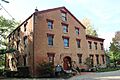
- The John Stump House and Mill southwest of Germantown, listed in 1975, combines a home with a working mill.
- Trailsend in Kettering, listed in 1979, is another historic home.
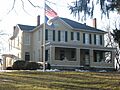
- The Watkins House south of Centerville, listed in 1974, is another example of the area's older homes.
Churches and Community Buildings
Some historic listings include important community buildings like churches and train stations.
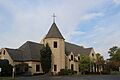
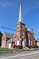
- Emmanuel's Evangelical Lutheran Church in Germantown, listed in 1990, is a significant religious building.
- Jacob's Church in Miamisburg, listed in 1990, is another historic church.
- The Salem Bear Creek Church, Salem Evangelical Lutheran Church in Moraine, listed in 1990, is also recognized for its historical importance.
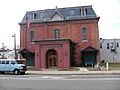
- The Trotwood Railroad Station and Depot in Trotwood, listed in 1981, is a reminder of the importance of trains in the past.
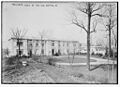
- The Wright Library in Oakwood, listed in 2013, is a historic public building.
Historic Districts and Areas
Some listings are entire historic districts, which means a group of buildings or an area that has historical importance.
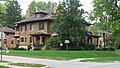
- The Centerville Historic District in Centerville, listed in 1974, includes many historic buildings in the town center.
- Gunckel's Town Plan Historic District in Germantown, listed in 1976, shows an old town layout.
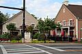
- Market Square in Miamisburg, listed in 1975, includes important streets and buildings in the town's center.
- The Schantz Park Historic District in Oakwood, listed in 1992, is another area with many historic properties.
Ancient Sites and Landmarks
Montgomery County also has very old sites, including ancient mounds built by early peoples.
- Carlisle Fort south of Germantown, listed in 1974, is an ancient site.
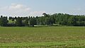
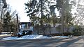
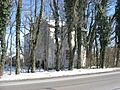
- The Miamisburg Mound southeast of Miamisburg, listed in 1970, is a very old mound built by Native Americans.
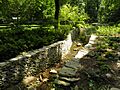
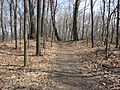
- The Wolf Creek Mound west of Trotwood, listed in 1973, is another ancient mound.
Other Notable Listings
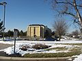
- The Miami-Erie Canal Lock No. 70 in Huber Heights, listed in 1982, is a part of an old canal system that was important for transportation.
- Shuey's Mill in Germantown, listed in 1975, is an old mill that played a role in the local economy.
- The Miami Valley Golf Course and Clubhouse in Harrison Township, listed in 2015, is a historic sports and social venue.
Former Listings
Sometimes, a historic place might be removed from the National Register. This can happen if the building is destroyed or if its historical features are changed too much.
- The John Beard Farm in Vandalia was listed in 1978 but removed in 1999.
- The Germantown Covered Bridge in Germantown was listed in 1971 but removed in 1999.
Images for kids
-
The historic Arnold Homestead.
-
The Aullwood House and Garden.
-
The Ausenbaugh-McElhenny House.
-
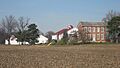
The George Bixler Farm.
-
The Robert Bradford House.
-
The Erma Bombeck House.
-
The Carlisle Fort.
-
A street scene in the Centerville Historic District.
-
The Deerwood Farmhouse.
-
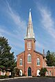
Emmanuel's Evangelical Lutheran Church.
-

The Joseph Flory House.
-
Fox Hollow near Centerville.
-
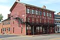
The Florentine Hotel in Gunckel's Town Plan Historic District.
-
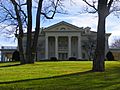
Hawthorn Hill, a National Historic Landmark.
-
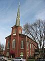
Jacob's Church in Miamisburg.
-
The Ethol Kellog House.
-
The Charles F. Kettering House, which burned down in 1995.
-
The Koehne-Poast Farm.
-
The Krug House in Union.
-
The Long-Mueller House.
-
The Long-Romspert House.
-
The Baum Opera House in Market Square, Miamisburg.
-
The Samuel Martindale House.
-
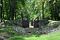
Miami-Erie Canal Lock No. 70.
-
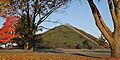
The Miamisburg Mound.
-
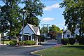
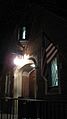
The entrance to the Miami Valley Golf Club.
-
Normandy Farms.
-
The Pease Homestead.
-
The David Rohr Mansion.
-
Salem Bear Creek Church.
-
A street in Schantz Park Historic District.
-
The Adam Schantz, Sr., House.
-
The Schuter Carpenter Shop and House.
-
Shuey's Mill.
-
Skywood Farms.
-
The Samuel Spitler House.
-
The John Stump Mill.
-
The Taylorsville Canal Inn.
-
Trailsend.
-
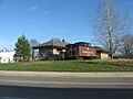
The Trotwood Railroad Station.
-
The Watkins House.
-
The entrance to the Wright Library.
-
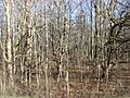
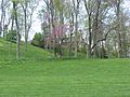
Sycamore State Park near the Wolf Creek Mound.
-
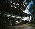
The Germantown Covered Bridge, a former listing.


.jpg)
