
National Register of Historic Places listings in Newberry County, South Carolina facts for kids

Newberry County in South Carolina, United States, is home to many amazing historic places! These special spots are listed on the National Register of Historic Places. This list helps protect and celebrate buildings, neighborhoods, and other sites that tell important stories about the past.
Imagine a map of Newberry County. All the places on this list are marked on it, showing you exactly where these pieces of history are located. There are 35 different properties and areas in Newberry County that are currently on the National Register. Plus, two other places were once listed but have since been removed.
What is the National Register of Historic Places?
The National Register of Historic Places is like a special club for historic sites across the United States. It's the official list of places that are important for their history, architecture, archaeology, engineering, or culture. When a place is added to this list, it means it's recognized as a valuable part of our country's heritage.
Why are places listed?
Places get listed for many reasons. Maybe a famous person lived there, or an important event happened. Sometimes, it's because the building itself is a great example of a certain type of architecture. Being on the list encourages people to preserve these sites for future generations.
Historic Places in Newberry County
Newberry County has a rich history, and you can see it in the many places listed on the National Register. These sites include old homes, churches, schools, and even entire neighborhoods!
Notable Homes and Buildings
Many of the listings are historic houses, each with its own story.
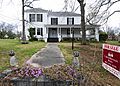
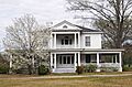
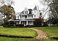
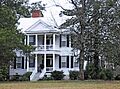
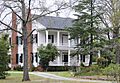
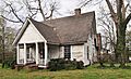
- The Jacob Bedenbaugh House in Prosperity was added to the list in 2011.
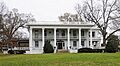
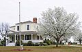
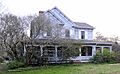
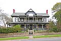
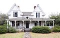
- The Burton House and Coateswood are two beautiful homes in Newberry. Coateswood was listed way back in 1975!
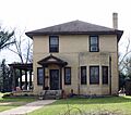
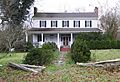
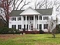
- The Cousins House and Francis B. Higgins House are also in Newberry.
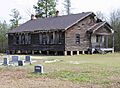
- In Pomaria, you can find the Folk-Holloway House and the Hatton House.
- The Moon-Dominick House is located northeast of Chappells.
- The George Mower House and Frederick Nance House are more historic homes in Newberry.
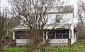
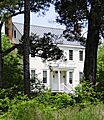
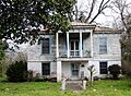
- The Ike Reighley House, Timberhouse, and Osborne Wells House also add to Newberry's historic charm.
Important Schools and Institutions
History isn't just about homes; it's about community places too!
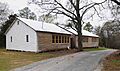
- The Hannah Rosenwald School in Newberry was built in 1925. It was a "three-teacher" Rosenwald school, which were special schools built for African American children in the early 20th century.
- The Hope Rosenwald School is another one of these important schools, located in Pomaria.
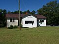
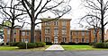
- Howard Junior High School in Prosperity was added to the list in 2006.
- The Newberry County Memorial Hospital is also recognized for its historical significance.
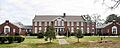
- Newberry College Historic District includes the campus of Newberry College, a long-standing educational institution.
Historic Districts and Areas
Sometimes, it's not just one building but a whole area that's historic. These are called historic districts.
- The Boundary Street-Newberry Cotton Mills Historic District in Newberry shows the history of the cotton industry.
- The Caldwell Street Historic District and College Street Historic District highlight important residential areas in Newberry.
- The Harrington Street Historic District and Main Street Historic District cover more historic parts of Newberry.
- The Little Mountain Historic District includes parts of Pomaria, Church, Main, and Mountain Streets in Little Mountain.
- The Newberry Historic District is a large area in Newberry that includes many important buildings.
- The Vincent Street Historic District and West Boundary Street Historic District are also significant areas in Newberry.
Other Unique Historic Sites
Newberry County also has other unique places on the list.
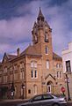
- The Newberry Opera House is a beautiful old theater in Newberry, listed in 1969. It's a great place to see shows!
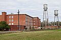
- The Oakland Mill is a textile mill in Newberry, with its first parts built between 1910 and 1912.
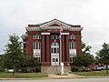
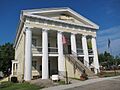
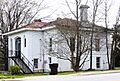
- The Old Courthouse in Newberry, listed in 1971, is another important public building.
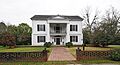
- Pomaria (also known as the Summer-Huggins House) is a historic home southeast of Pomaria.
- The Prosperity Cemetery in Prosperity is a historic burial ground.
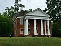
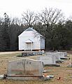
- St. John's Lutheran Church is a historic church located southeast of Pomaria.
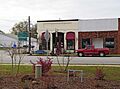
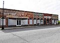
- The Summer Brothers Stores are historic commercial buildings in Newberry.
- The Wells Japanese Garden in Newberry is a unique and beautiful historic garden.
Former Listings
Sometimes, a property might be removed from the National Register of Historic Places. This can happen for different reasons, like if a building is torn down or moved.
- Oakhurst in Newberry was delisted in 2005 because it was demolished.
- The Stewart House in Newberry was also delisted in 2005 after it was moved to a new location.
These lists help us remember and appreciate the rich history of Newberry County.
Images for kids
-
The Jacob Bedenbaugh House.
-
The Boundary Street Cotton Mills Historic District.
-
The Caldwell Street Historic District.
-
Coateswood, a historic home.
-
The College Street Historic District.
-
The Cousins House.
-
The Folk-Holloway House.
-
The Hannah Rosenwald School.
-
The Harrington Street Historic District.
-
The Hatton House.
-
The Francis B. Higgins House.
-
The Hope Rosenwald School.
-
Howard Junior High School.
-
The Little Mountain Historic District.
-
The Main Street Historic District.
-
The Moon-Dominick House.
-
The George Mower House.
-
The Frederick Nance House.
-
The Newberry College Historic District.
-
The Newberry County Memorial Hospital.
-
The Newberry County Courthouse, part of the Newberry Historic District.
-
The Newberry Opera House.
-
The Oakland Mill.
-
The Old Courthouse.
-
Pomaria (Summer-Huggins House).
-
The Ike Reighley House.
-
St. John's Lutheran Church.
-
The Summer Brothers Stores.
-
Timberhouse.
-
The Vincent Street Historic District.
-
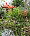
The Wells Japanese Garden.
-
The Osborne Wells House.
-
The West Boundary Street Historic District.


