
National Register of Historic Places listings in Olympic National Park facts for kids
Olympic National Park in Washington State is a truly special place, filled with amazing nature and important history. Did you know that many old buildings and sites within the park are protected because they are part of the National Register of Historic Places? This register is like a special list of places across the United States that are important to our country's history.
There are 33 historic places listed in Olympic National Park. These sites help us learn about how people lived, worked, and explored this beautiful area a long time ago. They include old cabins, ranger stations, fire lookouts, and even ancient village sites. Protecting these places helps us remember the past and understand how the park has changed over time.
Contents
Historic Buildings and Structures
Many of the historic places in Olympic National Park are buildings that were used by early settlers, park rangers, or visitors. These structures show us the different ways people interacted with the park's wild environment.
Community Kitchens and Lodges
Some buildings were made for people visiting the park. The Altair Campground Community Kitchen and the Elwha Campground Community Kitchen were built by the Civilian Conservation Corps (CCC). The CCC was a program during the 1930s that helped young men find work during a tough economic time. They built many parks and trails. These kitchens were central places where campers could cook and gather. Floods in 2015 might have damaged them, showing how nature can impact even historic sites.
The Enchanted Valley Chalet is a special lodge deep in the backcountry. It was a place where visitors could stay after a long hike. Today, it's facing challenges from the river changing its path, which shows how important it is to protect these old buildings from nature's forces.
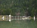
Two other famous lodges are found near Lake Crescent. The Rosemary Inn and Singer's Lake Crescent Tavern (also known as Lake Crescent Lodge) offered beautiful places for people to relax and enjoy the lake. These lodges are still popular today, letting new generations experience the park's charm.
Ranger Stations and Guard Stations
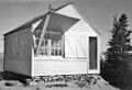
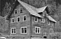
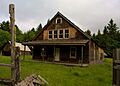
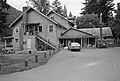
Park rangers have always played a key role in protecting Olympic National Park. Many historic ranger stations and guard stations are still standing. These include the Eagle Ranger Station, Elkhorn Guard Station, Elwha Ranger Station, Graves Creek Ranger Station, North Fork Quinault Ranger Station, and Olympus Guard Station. These stations were important bases for rangers who watched over the park, fought fires, and helped visitors. They often show a rustic style of architecture that fits in with the natural surroundings.
The Storm King Ranger Station is another example, located near Lake Crescent. These stations remind us of the hard work and dedication of the people who helped create and protect our national parks.
Cabins and Homesteads
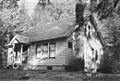
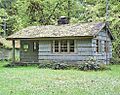
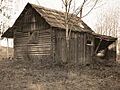
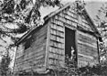
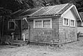
Imagine living in the wilderness! Several historic cabins and homesteads tell the story of early settlers and trappers in the area. The Botten Cabin and Elk Lick Lodge are examples of these remote shelters. The Humes Ranch Cabin on the Elwha River is another historic home, showing how people lived off the land.
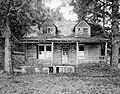
The Kestner Homestead and Peter Roose Homestead are also listed. Homesteads were places where families tried to make a new life in the wild, often building their own homes and farming the land. These sites give us a glimpse into the challenging lives of pioneers.
Trail Shelters
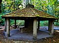
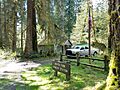
For hikers exploring the vast wilderness of Olympic National Park, trail shelters provided a safe place to rest. The Canyon Creek Shelter, Fifteen Mile Shelter, Happy Four Shelter, Hyak Shelter, North Fork Sol Duc Shelter, Pelton Creek Shelter, and Three Forks Shelter are all examples of these rustic structures. They were often built simply, using natural materials, to blend in with the environment and offer protection from the weather.
Lookouts and Important Sites
Beyond buildings, other types of historic places in the park include fire lookouts and significant cultural sites.
Fire Lookouts
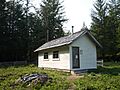
Keeping an eye out for wildfires has always been crucial in national parks. The Dodger Point Fire Lookout was used to spot fires from high up. These lookouts were vital for protecting the forests and wildlife of the park.
During World War II, the Pyramid Peak Aircraft Warning Service Lookout was built. Its purpose was to watch for enemy planes, showing how even remote areas like Olympic National Park played a part in national defense.
Other Historic Sites
The Glines Canyon Hydroelectric Power Plant was once a dam on the Elwha River. It was important for generating electricity. However, the dam was removed in 2012 as part of a huge project to restore the river and help salmon return to their natural spawning grounds. This shows that sometimes, removing a historic structure can be important for the environment.
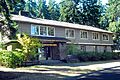
The Olympic National Park Headquarters Historic District is where the park's main offices are located. This area includes several buildings that are important to the park's administration and history.
The Michael's Cabin and Wendel Property are other specific sites that have been recognized for their historical value within the park.
Ancient Village and Petroglyphs
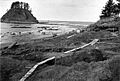
Some of the most fascinating historic sites are much older. The Ozette Indian Village Archeological Site is an ancient village of the Makah people. Its exact location is kept secret to protect it. This site has taught us a lot about the lives of Native Americans who lived here thousands of years ago.
The Wedding Rock Petroglyphs are ancient rock carvings found in the park. Petroglyphs are images carved into rock, often by early peoples, and they can tell us stories or show symbols from their culture. These sites are incredibly important for understanding the deep history of human life in this region.
Images for kids
-
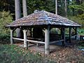
The Altair Campground Community Kitchen, built by the Civilian Conservation Corps.
-
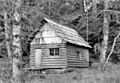
The historic Botten Cabin in Olympic National Park.
-
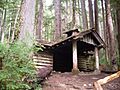
A rustic trail shelter at Canyon Creek.
-
The Dodger Point Fire Lookout, used to spot wildfires.
-
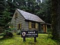
The historic Eagle Ranger Station.
-
The Elwha Campground Community Kitchen.
-
A building at the Elwha Ranger Station.
-
The Enchanted Valley Chalet, a backcountry lodge.
-
The Glines Canyon Hydroelectric Power Plant before its removal.
-
The Graves Creek Ranger Station.
-
The Humes Ranch Cabin on the Elwha River.
-
The Kestner Homestead.
-
The North Fork Quinault Ranger Station.
-
The Olympic National Park Headquarters building.
-
The Ozette Indian Village Archeological Site.
-
The Pyramid Peak Aircraft Warning Service Lookout.
-
The Peter Roose Homestead.
-
The historic Rosemary Inn on Lake Crescent.
-
Singer's Lake Crescent Tavern, also known as Lake Crescent Lodge.
-
The Storm King Ranger Station near Lake Crescent.
-
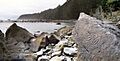
Ancient petroglyphs at Wedding Rock.


.JPG)


