
National Register of Historic Places listings in Orange County, North Carolina facts for kids

Orange County, North Carolina, is a place with a rich history! Many old buildings and areas here are so important that they are listed on the National Register of Historic Places. This is a special list kept by the United States government to help protect places that are important to American history, architecture, or culture. When a building or area is on this list, it means it's a valuable part of our past that we should try to keep safe for the future.
This page will tell you about some of these amazing historic places in Orange County. You'll learn about old homes, schools, mills, and even entire neighborhoods that have played a big part in shaping the area.
Contents
What are Historic Places?
Historic places are buildings, sites, or areas that have special meaning because of their past. They might be very old, or they might be connected to important events or people. For example, a house where a famous person lived, a school where many generations learned, or a factory that helped a town grow could all be considered historic.
When a place is added to the National Register of Historic Places, it gets special recognition. This helps people understand why the place is important and encourages them to take care of it. It can also help protect these places from being torn down or changed too much.
Exploring Orange County's Historic Gems
Orange County has many different types of historic places. Let's explore a few of them!
Old Buildings with New Stories
Many of Orange County's historic places are old buildings that once served important purposes.
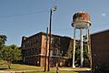
Alberta Mill Complex
The Alberta Mill Complex in Carrboro is an old mill building. Mills were places where raw materials, like cotton, were turned into useful products. This mill helped Carrboro grow and provided jobs for many people. Today, it's known as Carr Mill Mall and is a busy shopping center, showing how old buildings can find new life!
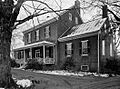
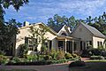
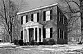
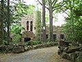
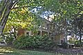
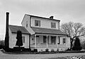
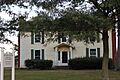
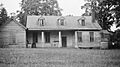
Ayr Mount
Ayr Mount is a beautiful old house in Hillsborough. It was built a long time ago and shows us what homes looked like in the past. Walking through it is like taking a step back in time!
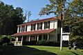
Bellevue Manufacturing Company
Also in Hillsborough, the Bellevue Manufacturing Company was another important industrial building. Places like this were key to the economy of the area, creating goods and jobs.
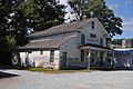
Eno Cotton Mill
The Eno Cotton Mill, located in Hillsborough, is another example of a historic mill. These mills were central to the economy of North Carolina for many years, turning cotton into fabric.
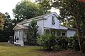
Nash Law Office
The Nash Law Office in Hillsborough is a small building that was once used as a law office. It reminds us of how legal work was done in earlier times and the people who helped shape the laws of the community.
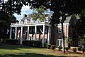
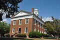
Old Orange County Courthouse
The Old Orange County Courthouse in Hillsborough is a very important building. Courthouses are where legal decisions are made and where many community events happen. This building has seen a lot of history unfold within its walls.
Places of Learning and Fun
Some historic places are connected to education or entertainment.
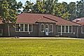
Bingham School
The Bingham School near Oaks was an important school in its day. Schools are vital parts of any community, helping young people learn and grow. This old school building tells a story of education in the past.
Burwell School
The Burwell School in Hillsborough was a school for girls in the 1800s. It's a great example of how education was provided long ago and the efforts made to teach young women.
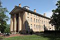
Old East, University of North Carolina
Old East is a very special building on the University of North Carolina campus in Chapel Hill. It's the oldest building on the campus and has been a part of university life for centuries. Imagine all the students who have walked through its doors!
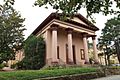
Playmakers Theatre
Also on the UNC campus, the Playmakers Theatre is a historic theater. It's where plays and performances have been held for many years, bringing stories and entertainment to the community.
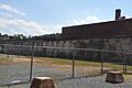
Occoneechee Speedway
The Occoneechee Speedway in Hillsborough is a unique historic site. It was once a famous race track where cars sped around. It's a reminder of the early days of car racing and a fun part of the area's history.
Important Historic Districts
Sometimes, it's not just one building that's historic, but a whole area or neighborhood. These are called historic districts.
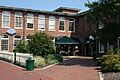
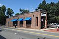
Carrboro Commercial Historic District
The Carrboro Commercial Historic District includes a block of old shops and businesses in Carrboro. These buildings show what the town's main street looked like when it was first growing.
Chapel Hill Historic District
The Chapel Hill Historic District covers a large part of downtown Chapel Hill, including parts of the university campus. This area has many old homes, churches, and university buildings that together tell the story of Chapel Hill's development.
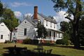
Hillsborough Historic District
The Hillsborough Historic District is a large area in Hillsborough with many historic homes and buildings. Walking through this district, you can see different styles of architecture from different time periods, giving you a sense of the town's long history.
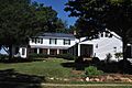
Rocky Ridge Farm Historic District
The Rocky Ridge Farm Historic District in Chapel Hill is an example of a historic neighborhood. These districts help preserve the look and feel of older communities.
These are just a few of the many amazing historic places in Orange County. Each one has a unique story to tell about the people and events that shaped this part of North Carolina. Visiting them can be a fun way to connect with the past!
Images for kids
-
Alberta Mill Complex
-
Ayr Mount
-
Bellevue Manufacturing Company
-
Beta Theta Pi Fraternity House
-
Bingham School
-
Burwell School
-

Carolina Inn
-
Carrboro Commercial Historic District
-
Cedar Grove Rural Crossroads Historic District
-
Chapel Hill Historic District
-
Chapel Hill Town Hall
-
Chapel of the Cross
-
Commandant's House
-
Eagle Lodge
-
Eno Cotton Mill
-
Faucett Mill and House
-
David Faucette House
-
Gimghoul Neighborhood Historic District
-
Hazel-Nash House
-
Heartsease
-
Hillsborough Historic District
-

Alexander Hogan Plantation (image for restricted address)
-
Thomas and Mary Hogan House
-

Holden-Roberts Farm
-
Jacob Jackson Farm
-
Dr. Arch Jordan House
-

Thomas F. Lloyd Historic District
-
Montrose
-
Moorefields
-
Murphey School
-
Nash Law Office
-
Nash-Hooper House
-
Occoneechee Speedway
-
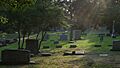
Old Chapel Hill Cemetery
-
Old East, University of North Carolina
-
Old Orange County Courthouse
-
Playmakers Theatre
-
Capt. John S. Pope Farm
-
Rigsbee's Rock House
-
Rocky Ridge Farm Historic District
-
Ruffin-Roulhac House
-
Sans Souci
-
St. Mary's Chapel
-
St. Matthew's Episcopal Church and Churchyard
-
West Chapel Hill Historic District

.jpg)


.jpg)


.jpg)
.jpg)


.jpg)

.jpg)
.jpg)


.jpg)


.jpg)

