
National Register of Historic Places listings in Otsego County, New York facts for kids

Have you ever wondered about the oldest or most special buildings and places in your area? In Otsego County, New York, there's a list of amazing spots that are officially recognized for their history, cool architecture, or important events that happened there. This list is called the National Register of Historic Places. It's like a special hall of fame for buildings, neighborhoods, and even old farms!
When a place is added to this list, it means it's important to our country's story. It helps protect these places so future generations can learn from them. One super special place in Otsego County, Hyde Hall, is even called a National Historic Landmark. This means it's one of the most important historic sites in the entire United States!
This article will tell you about some of these fascinating places in Otsego County.
Contents
Cool Buildings and Homes
Otsego County is home to many unique and historic buildings. Let's explore a few!
Historic Houses and Mansions
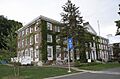
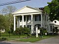
- Fairchild Mansion: Located in Oneonta, this beautiful mansion at 318 Main Street was added to the list in 1974. It's a great example of old architecture.
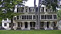
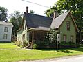
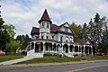
- Kenyon Residences: In Mt. Vision, you'll find two historic homes at 60 and 62 Main Street. They were recognized in 2004.
- George I. Wilber House: Another Oneonta gem, this house at 11 Ford Avenue joined the list in 2000.
- Swart-Wilcox House: This house in Oneonta, at the corner of Wilcox Avenue and Henry Street, became historic in 1990.
- Warren Ferris House: Found on NY 80 in Springfield Center, this house from 1894 is a great example of the Queen Anne style. It was built by a local builder and added to the list in 2016.
- Lemuel F. Vibber House: Near Richfield, this early 19th-century house is the only remaining part of an old industrial area called Federal Corner. It was listed in 2016.
- The White House: In Hartwick, this historic house at 108 White House Road was added in 2012.
Special Churches and Chapels
- All Saints Chapel and Morris Family Burial Ground: South of Morris on State Route 51, this chapel and burial ground were listed in 1997. It's a peaceful and historic spot.
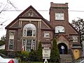
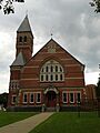
- Chapin Memorial Church: This church at 12 Ford Avenue in Oneonta became a historic place in 2002.
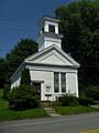
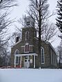
- Fly Creek Methodist Church: Located on County Route 26 in Fly Creek, this church was recognized in 1996.
- Otsdawa Baptist Church: On County Road 8 in Otsdawa, this church was added to the list in 2002.
- St. Mary's Episcopal Church Complex: In Springfield Center, this church complex from the late 1800s mixes Shingle and Gothic Revival styles. It was listed in 2015.
- West Burlington Memorial Church: On State Route 80 in West Burlington, this church was added in 2001.
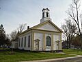
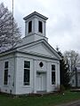
- Zion Episcopal Church Complex and Harmony Cemetery: East of Morris on State Route 51, this church and cemetery complex were listed in 1997.
Unique Barns and Farms
- Baker Octagon Barn: This cool eight-sided barn on State Route 28 in Richfield Springs was listed in 1984.
- Lunn-Musser Octagon Barn: Another octagon barn, this one is south of Garrattsville and was also listed in 1984.
- Beardslee Farm: Located in Pittsfield at State Route 80 and County Road 18, this farm became a historic district in 2000.
- Morris-Lull Farm: This farm at 133 Peet Road in Morris was recognized in 2005.
- Mathewson–Bice Farmhouse and Mathewson Family Cemetery: Near Cooperstown, this farmhouse from the late 1700s shows how early settlers from New England built their homes. The family cemetery dates back to 1813. It was listed in 2013.
- Stonehouse Farm: East of Oneonta on State Route 7, this farm was added to the list in 1980.
Historic Villages and Areas
Many towns and parts of towns in Otsego County are recognized as historic districts. This means that a whole area, not just one building, is special!
Village Historic Districts
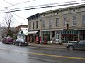
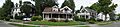
- Cherry Valley Village Historic District: This district in Cherry Valley, roughly bounded by Alden and Montgomery Streets, Maple and Elm Avenues, and Main Street, was listed in 1988. A large rural area was added to it in 1995.
- Cooperstown Historic District: The heart of Cooperstown, including State Routes 28 and 80 and Main Street, became a historic district in 1980. Some old farm buildings were added in 1997.
- Fly Creek Historic District: This district in Fly Creek includes several roads like State Routes 28 and 80, County Road 26, and Cemetery Road. It was listed in 2006.
- Gilbertsville Historic District: Originally focused around Marion Avenue, Cliff and Green Streets, and Grover and Sylvan Streets, this district was expanded in 1982 to cover most of Gilbertsville. It was first listed in 1974.
- Hartwick Historic District: Roughly along State Route 205, County Road 11, and Weeks Road, this district in Hartwick was recognized in 2013.
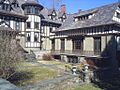
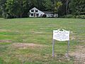
- Middlefield Hamlet Historic District: This district in Middlefield, including County Road 35, Rezen, Whiteman, and Long Patent Roads, was listed in 1985.
- Morris Village Historic District: The central part of Morris village, with Main, Lake, Broad, Grove, and Church streets, was listed in 2013. It's special because it was settled by people escaping the French Revolution.
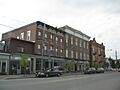
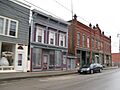
- Oneonta Downtown Historic District: The downtown area of Oneonta, including Main, Chestnut, Dietz, Market, Elm, Water, Wall, and South Main Streets, became a historic district in 2003.
- Roseboom Historic District: This district in Roseboom, along State Routes 166 and 165, Beaver, John Deer, and Gage Roads, was listed in 1998.
- South Worcester Historic District: At the junction of County Route 40 and County Route 39 in South Worcester, this district was recognized in 1992.
- Unadilla Village Historic District: This district in Unadilla, roughly along Main Street from Hopkins Street to Butternut Road and Bridge Street from Main to Watson Street, was listed in 1992.
- Walnut Street Historic District: In Oneonta, this district includes Ford Avenue, Walnut, Dietz, Elm, and Maple Streets. It was listed in 1980.
- West Main Street-West James Street Historic District: This district in Richfield Springs, along West Main, West James, Elm, and Center Streets, and Taylor Avenue, was listed in 1994.
- Worcester Historic District: Both sides of Main Street (State Route 7) between Decatur and Cook Streets in Worcester became a historic district in 1975.
Other Historic Districts
- Church Street Historic District: In Richfield Springs, this district is roughly bounded by Church, Sylvan, Gould, and Warren Streets. It was listed in 1997.
- East Main Street Historic District: Also in Richfield Springs, this district runs along East Main Street from Church Street to the Richfield Springs reservoirs. It was listed in 1995.
- Glimmerglass Historic District: This large district covers Otsego Lake and its surroundings near Cooperstown. It was recognized in 1999.
Important Public Buildings and Sites
Many public buildings also have a special place in history.
Schools and Offices
- Bresee Hall: This building on Hardwick Drive in Oneonta was listed in 1984.
- East Springfield Union School: About half a mile east of the junction of US 20 and County Road 31 in East Springfield, this school was listed in 1996.
- Middlefield District No. 1 School: On County Road 35 in Cooperstown, this old schoolhouse was listed in 1987.
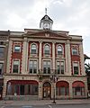
- Municipal Building: The Municipal Building at 238-242 Main Street in Oneonta was listed in 1982.
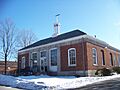
- Old Post Office (Oneonta): The historic Post Office on Main Street in Oneonta was listed in 1978.
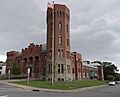
- Oneonta Armory: This armory building at 4 Academy Street in Oneonta was listed in 1995.
- Springfield Center Elementary School: At 129 County Road 29A in Springfield Center, this school was listed in 2011.
- Unadilla Forks School: This school at 113 State Route 18A in Unadilla Forks was listed in 1998.
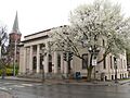
- US Post Office-Cooperstown: The Post Office at 28-40 Main Street in Cooperstown was listed in 1988.
- US Post Office-Richfield Springs: The Post Office at 152 Main Street in Richfield Springs was listed in 1989.
Other Public Structures
- Otsego County Courthouse: The courthouse at 193 Main Street in Cooperstown was listed in 1972.
- Oneonta Theatre: This theater at 47 Chestnut Street in Oneonta was listed in 2002.
- Ford Block: This building at 188-202 Main Street in Oneonta was listed in 1984.
- Major's Inn and Gilbert Block: These buildings on Commercial Street near State Route 51 in Gilbertsville were listed in 1973.
- Andrew Mann Inn: At 33 Riverside Road in Unadilla, this inn was listed in 1980.
- Roswell Wright House: This house at 25 Main Street in Unadilla was listed in 1988.
Special Sites and Structures
Some places are listed for very specific reasons, like unique structures or important historical events.
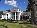
- Hyde Hall: This incredible building, south of Springfield Center in Glimmerglass State Park, is a National Historic Landmark. It was recognized in 1971.
- Hyde Hall Covered Bridge: This historic covered bridge on East Lake Road over Shadow Brook, near East Springfield, was listed in 1998.
- Gilbertsville Water Works: The water works on Reservoir Road near Gilbertsville were listed in 2011.
- Unadilla Waterworks: These waterworks, at the junction of Kilkenny Road and Clifton Street and Martin Brook Road and Rod & Gun Club Road in Unadilla, were listed in 1992.
- Fly Creek Grange No. 844: This grange hall at 208 Cemetery Road in Fly Creek was listed in 2004.
- The Tepee: This unique structure at 7632 US 20 near Cherry Valley was listed in 2011.
- Twentieth Century Steam Riding Gallery No. 409: This historic carousel or riding gallery on Race Street in Schenevus was listed in 1998.
- Women's Community Club of South Valley: This club building at 472 Kirshman Hill Road in South Valley (Roseboom) was listed in 1999.
Former Listings
Sometimes, a place might be removed from the National Register if it no longer exists or its historical importance changes.
- Oneonta State Normal School: The Old Main building of this school in Oneonta was listed in 1977, but it was demolished that same year, so it was removed from the list.
Images for kids
-
Bresee Hall in Oneonta.
-
Chapin Memorial Church in Oneonta.
-
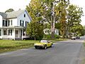
A street in the Cherry Valley Village Historic District.
-
A building in the Cooperstown Historic District.
-
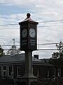
A clock in the East Main Street Historic District, Richfield Springs.
-
Fairchild Mansion in Oneonta.
-
A view of the Fly Creek Historic District.
-
Fly Creek Methodist Church.
-
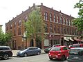
Ford Block in Oneonta.
-
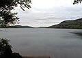
Otsego Lake, part of the Glimmerglass Historic District.
-
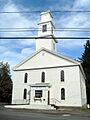
First Baptist Church in the Hartwick Historic District.
-
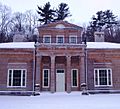
Hyde Hall, a National Historic Landmark.
-
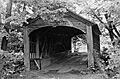
Hyde Hall Covered Bridge.
-
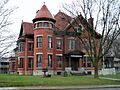
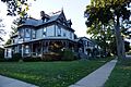
Kenyon Residences in Mt. Vision.
-
Major's Inn and Gilbert Block in Gilbertsville.
-
A cottage in the Middlefield Hamlet Historic District.
-
Municipal Building in Oneonta.
-
The Old Post Office in Oneonta.
-
Oneonta Armory.
-
Elm Street in the Oneonta Downtown Historic District.
-
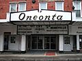
Oneonta Theatre.
-
Otsego County Courthouse.
-
Methodist Church in the Roseboom Historic District.
-
Methodist Church in the South Worcester Historic District.
-
Swart-Wilcox House in Oneonta.
-
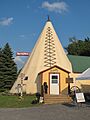
The Tepee near Cherry Valley.
-
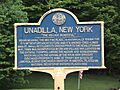
A marker in the Unadilla Village Historic District.
-
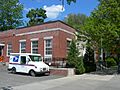
US Post Office in Cooperstown.
-
US Post Office in Richfield Springs.
-
Walnut Street Historic District in Oneonta.
-
A street in the West Main Street-West James Street Historic District, Richfield Springs.
-
George I. Wilber House in Oneonta.
-
A view of the Worcester Historic District.
-
Roswell Wright House in Unadilla.
-
Zion Episcopal Church in Morris.


.jpg)


