
National Register of Historic Places listings in Ouachita Parish, Louisiana facts for kids

Have you ever wondered which buildings and places are super important to history? In Ouachita Parish, Louisiana, there's a special list of these places! It's called the National Register of Historic Places. This list helps protect old buildings and sites that tell us about the past.
When a place is on this list, it means it's recognized by the United States government as being historically important. It could be an old house, a school, a church, or even a whole neighborhood! Ouachita Parish has 32 places on this list. One place was on the list but has since been removed. Let's explore some of these amazing historic spots!
What is the National Register of Historic Places?
The National Register of Historic Places is like a hall of fame for buildings, structures, objects, sites, and districts. It's the official list of the nation's historic places worth saving. Being on the list means a place is important to local, state, or national history. It helps people understand and appreciate the past. It also encourages communities to preserve these special places for future generations.
Historic Places in Ouachita Parish
Ouachita Parish is full of interesting historic sites. These places show us how people lived, worked, and built their communities over many years. From grand old homes to important downtown areas, each spot has a story to tell.
Homes with History
Many of the places on the list are old houses. These homes often belonged to important people or show unique styles of building from long ago.
- The Allen-Barringer House is a historic home located southwest of West Monroe, Louisiana. It was added to the list in 1982.
- The Bosco Plantation House and Boscobel Cottage are both in the Monroe area. They were listed in 2009 and 1979, respectively.
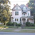
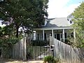
- The Bright-Lamkin-Easterling House in Monroe, Louisiana is a beautiful home listed in 1986.
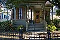
- The Bynum House and Harvey House are two more historic homes in Monroe, both added in 1997.
- The G.B. Cooley House and Roland M. Filhiol House are also important Monroe residences. They were listed in 1986 and 1995.
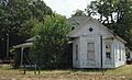
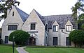
- The Grayson House and Gov. Luther Hall House are other notable Monroe homes. The Grayson House was listed in 1999, and the Gov. Luther Hall House in 1979.
- The Key-Mize House is a historic home in West Monroe, listed in 2001.
- The Masur House in Monroe is now the Masur Museum of Art, a place where you can see art! It was listed in 1982.
- The McClendon House is another historic home in West Monroe, listed in 1996.
- Mulberry Grove, Lower Pargoud, Slagle House, Whitehall Plantation House, and Wossman House are all significant historic homes in Monroe. They were listed between 1978 and 1999.
Important Buildings and Districts
Beyond individual homes, the list includes other types of buildings and even whole areas that are important to the parish's history.
- The J.S. Block Building is a historic business building in downtown Monroe, listed in 1980.
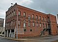
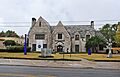
- The Downtown Monroe Historic District is a large area in Monroe. It includes many buildings that show what the city looked like long ago. It was added to the list in 1986.
- The Isaiah Garrett Law Office is a historic office building in Monroe, listed in 1976.
- The Miller-Roy Building and Milner Motors are two more historic commercial buildings in Monroe, listed in 2011 and 2001.
- The Monroe Residential Historic District is another important area in Monroe. It features many historic homes and buildings. It was listed in 1996.
- The Ouachita Coca-Cola Bottling Company, Inc.-Ouachita Candy Company, Inc. building is a historic industrial site in Monroe, listed in 2013.
Schools and Churches
Schools and churches often play a big role in a community's history.
- The First United Methodist Church in West Monroe was listed in 2001.
- Neville High School and Ouachita Parish High School are two historic schools in Monroe. Neville High School was listed in 1985, and Ouachita Parish High School in 1981.
- The Robinson Business College is another historic educational building in Monroe, listed in 1997.
Other Historic Sites
- Logtown Plantation is a historic plantation site south of Monroe, listed in 1980.
- The Rawls Cabin is a historic cabin located in West Monroe, listed in 1991.
Former Listing
Sometimes, a place might be removed from the National Register. This can happen if the building is changed too much or is no longer standing.
- The St. James United Methodist Church in Monroe was once on the list, added in 1992. However, it was removed in 2015.
Images for kids
-
The Bright-Lamkin-Easterling House in Monroe.
-
The Bynum House.
-
A view of the Downtown Monroe Historic District.
-
The Grayson House.
-

The Governor Luther Hall House.
-
The Key-Mize House.
-
The Masur House, now the Masur Museum of Art.
-

The Miller-Roy Building.
-
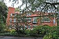
Mulberry Grove.
-
The Slagle House.


