
National Register of Historic Places listings in Perquimans County, North Carolina facts for kids

Have you ever wondered about old buildings and places that tell stories from the past? In Perquimans County, North Carolina, there are many special spots listed on the National Register of Historic Places. This is like a special list kept by the United States government. It helps protect important buildings, sites, and areas that have a big meaning in history, architecture, archaeology, engineering, or culture.
When a place is on this list, it means it's worth saving for future generations. It helps us learn about how people lived long ago and what was important to them. Perquimans County is full of these amazing historical treasures!
Contents
Exploring Historic Places in Perquimans County
Perquimans County has many historic buildings and areas. These places help us understand the past. Let's explore some of them.
Historic Homes and Estates
Many old homes in the county are on the National Register. These houses show us different styles of building from long ago.
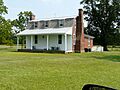
Belvidere and the Belvidere Historic District
The Belvidere house is a historic home located west of the Perquimans River. It was added to the list in 1977. Nearby, the Belvidere Historic District is a larger area with many old buildings. This district was recognized in 1999. It includes homes and other structures that show the history of the Belvidere community.
Cove Grove: A Glimpse into the Past
Cove Grove is another important historic home. It is found east of Hertford. This house was added to the list in 1974. It offers a look at how people lived in this area many years ago.
Land's End: Home of Colonel James Leigh
Land's End is a historic estate southeast of Hertford. It was once the home of Colonel James Leigh, who lived from 1781 to 1854. This beautiful property was added to the National Register in 1973. It reminds us of important people from the county's history.
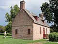
Myers-White House and Isaac White House
Near Bethel, you can find the Myers-White House. This home was listed in 1972. Also, the Isaac White House, located northeast of Bethel, joined the list in 1979. These houses are great examples of older architecture in the area.
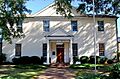
Newbold-White House: A Very Old Home
The Newbold-White House is one of the oldest homes on the list. It is southeast of Hertford. This house was recognized in 1971. It is a very special place that helps us imagine life centuries ago.
Stockton: A Historic Site in Woodville
Stockton is a historic property located south of Woodville. It was added to the list in 1974. This site is another example of the rich history found throughout Perquimans County.
Important Public Buildings and Churches
Besides homes, some public buildings and churches are also protected. They played a big role in the community's life.
Church of the Holy Trinity
The Church of the Holy Trinity is a beautiful church in Hertford. It is located on South Church Street. This church was added to the National Register in 1998. It is an important part of Hertford's history and community.
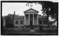
Perquimans County Courthouse
The Perquimans County Courthouse is in Hertford on Church Street. This building is very important because it's where many local government decisions have been made for a long time. It was listed in 1979.
Historic Districts: Preserving Whole Areas
Sometimes, not just one building, but a whole area is considered historic. These are called historic districts.
Hertford Historic District
The Hertford Historic District covers a large part of Hertford. It includes many streets and buildings near the Perquimans River. This district was recognized in 1998. It helps keep the historic feel of the town center.
Old Neck Historic District
The Old Neck Historic District is another important area near Hertford. It is bounded by US 17 and the Perquimans River. This district was added to the list in 1996. It shows how communities developed in this part of the county.
Winfall Historic District
The Winfall Historic District is located in Winfall. It includes areas along Main Street and Wiggins Road. This district was recognized in 2003. It helps preserve the historic character of Winfall.
Other Notable Historic Sites
Perquimans County has even more historic places that are important to its story.
Fletcher-Skinner-Nixon House and Outbuildings
The Fletcher-Skinner-Nixon House and Outbuildings are located southeast of Hertford. This property includes not just the main house but also other smaller buildings. It was added to the list in 1994.
Jonathan Hill Jacocks House
In New Hope Township, you can find the Jonathan Hill Jacocks House. This home is at the junction of New Hope Road and Jacocks Lane. It was listed in 1998.
Mitchell-Ward House
The Mitchell-Ward House is located in Belvidere. It is at the junction of NC 1119 and NC 1002. This house was added to the National Register in 1999.
Samuel Nixon House
The Samuel Nixon House is northwest of Hertford. It was recognized in 1973. This home is another example of the many historic residences in the county.
Sutton-Newby House
The Sutton-Newby House is located east of Hertford. It was added to the list in 1974. This house contributes to the rich history of homes in the Perquimans area.
Images for kids
-
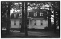
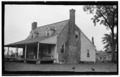
The Belvidere house, also known as Exum Newby House.
-
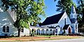
The Church of the Holy Trinity in Hertford.
-
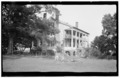
Cove Grove, a historic home near Hertford.
-
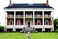
Land's End, the historic home of Col. James Leigh.
-
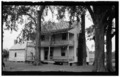
The Myers-White House.
-
The Newbold-White House, one of the oldest homes in the county.
-
The Perquimans County Courthouse in Hertford.
-
Stockton, a historic property in Woodville.
-
The Sutton-Newby House.
-
The Isaac White House.


.JPG)

