
National Register of Historic Places listings in Person County, North Carolina facts for kids

Imagine a special list of important buildings, places, and areas that are super old and have cool stories! This list is called the National Register of Historic Places. It's like a hall of fame for historic spots in the United States. When a place is on this list, it means it's really important to our country's history and culture.
In Person County, North Carolina, there are several amazing places that have made it onto this special list. These spots help us remember the past and learn about how people lived long ago. Let's explore some of these cool historic sites!
Contents
Historic Treasures in Person County
Here are some of the interesting places in Person County that are on the National Register of Historic Places:
Historic Homes and Plantations
Many of the places on the list are old homes or parts of former plantations. These buildings often show us how people lived, worked, and built things many years ago.
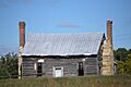
- Burleigh: This historic spot is located northwest of Concord. It was added to the list on May 1, 1980.
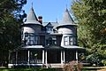
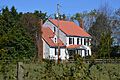
- Henry-Vernon House: You can find this house southwest of Bushy Fork. It became a historic place on February 3, 1983.
- Holloway-Jones-Day House: This house is in Roxboro and was recognized on June 9, 1988.
- Holloway-Walker Dollarhite House: Located near Bethel Hill, this house joined the list on June 1, 1982.
- House on Wagstaff Farm: This house is northeast of Roxboro. It was added to the list on April 5, 2006.
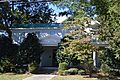
- James A. and Laura Thompson Long House: Found at 217 South Main Street in Roxboro, this home was recognized on April 6, 2005.
- Merritt-Winstead House: This house is at 7891 Boston Road in Roxboro. It became a historic site on September 15, 2005.
- Waverly Plantation: Located south of U.S. 58 near Cunningham, this plantation was added to the list on October 9, 1974.
Important Buildings and Districts
Besides homes, other types of buildings and even whole areas can be historic. These places often played a big role in the community's past.
- Person County Courthouse: This important building is on Main Street in Roxboro. It was added to the list on May 10, 1979. Courthouses are where important legal and community decisions happen.
- Roxboro Commercial Historic District: This is a whole area in Roxboro that includes many historic buildings. It's roughly around Courthouse Square and Main Street. It was recognized as a historic district on March 1, 1984. Historic districts help protect the look and feel of old town centers.
- Roxboro Cotton Mill: Located at 115 Lake Drive in Roxboro, this old mill was added to the list on August 27, 2009. Mills were very important for making goods like cloth in the past.
- Roxboro Male Academy and Methodist Parsonage: This site at 315 North Main Street in Roxboro was recognized on July 29, 1982. An academy is like an old school, and a parsonage is a home for a religious leader.
These places help us understand the rich history of Person County and North Carolina!
Images for kids
-
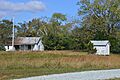
Outbuildings at Burleigh
-
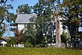
The Henry-Vernon House
-
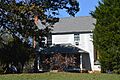
The Holloway-Jones-Day House
-
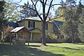
The Holloway-Walker Dollarhite House
-
The House on Wagstaff Farm
-
The James A. and Laura Thompson Long House
-
The Merritt-Winstead House
-
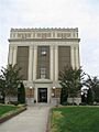
The Person County Courthouse
-
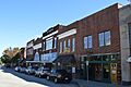
Main Street in the Roxboro Commercial Historic District
-
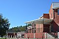
The Roxboro Cotton Mill, now Roxboro Community School
-
The Roxboro Male Academy and Methodist Parsonage
-
The Waverly Plantation House


