National Register of Historic Places listings in Phillips County, Kansas facts for kids
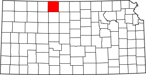
This is a list of the National Register of Historic Places listings in Phillips County, Kansas.
This is intended to be a complete list of the properties and districts on the National Register of Historic Places in Phillips County, Kansas, United States. The locations of National Register properties and districts for which the latitude and longitude coordinates are included below, may be seen in a map.
There are 9 properties and districts listed on the National Register in the county.
Current listings
| Name on the Register | Image | Date listed | Location | City or town | Description | |
|---|---|---|---|---|---|---|
| 1 | Agra Consolidated School |
(#05001246) |
941 Kansas Ave. 39°45′41″N 99°06′52″W / 39.761286°N 99.114555°W |
Agra | Now Thunder Ridge Middle School | |
| 2 | Agra Lake and Park |
(#08000616) |
¼ mile north of U.S. Route 36 on the west edge of Agra. 39°45′41″N 99°07′34″W / 39.761389°N 99.126111°W |
Agra | ||
| 3 | Battle Creek King Post Truss Bridge |
(#03000362) |
W. Eagle Rd., 3.0 miles east of its junction with Washington Rd. 39°56′39″N 99°28′47″W / 39.944072°N 99.479587°W |
Long Island | ||
| 4 | Hoff School District No. 42 |
(#10001140) |
Near intersection of E. Union Rd. and E. 1300 Rd. 39°42′50″N 99°05′05″W / 39.713757°N 99.084618°W |
Kirwin | Public Schools of Kansas MPS | |
| 5 | Jack Creek Kingpost |
(#89002188) |
Eagle Rd east of West 600 Rd 39°56′39″N 99°26′20″W / 39.944107°N 99.438804°W |
Long Island | ||
| 6 | Kirwin City Hall |
(#06000471) |
1st and Main Sts. 39°40′23″N 99°07′20″W / 39.673056°N 99.122222°W |
Kirwin | ||
| 7 | Long Island School |
(#05000551) |
Washington Street 39°56′47″N 99°32′04″W / 39.946472°N 99.534532°W |
Long Island | ||
| 8 | Phillipsburg Community Building |
(#10000845) |
425 F St. 39°45′26″N 99°19′22″W / 39.757301°N 99.322691°W |
Phillipsburg | New Deal-Era Resources of Kansas MPS | |
| 9 | Pleasant Ridge Church |
(#05001204) |
381 E. Buffalo Rd. 39°59′15″N 99°15′27″W / 39.987427°N 99.257433°W |
Phillipsburg |

All content from Kiddle encyclopedia articles (including the article images and facts) can be freely used under Attribution-ShareAlike license, unless stated otherwise. Cite this article:
National Register of Historic Places listings in Phillips County, Kansas Facts for Kids. Kiddle Encyclopedia.


