Phillips County, Kansas facts for kids
Quick facts for kids
Phillips County
|
|
|---|---|

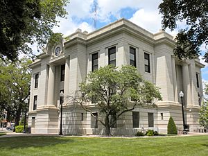
Phillips County Courthouse in Phillipsburg (2010)
|
|

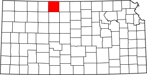
Location within the U.S. state of Kansas
|
|
 Kansas's location within the U.S. |
|
| Country | |
| State | |
| Founded | February 26, 1867 |
| Named for | William A. Phillips |
| Seat | Phillipsburg |
| Largest city | Phillipsburg |
| Area | |
| • Total | 895 sq mi (2,320 km2) |
| • Land | 886 sq mi (2,290 km2) |
| • Water | 8.7 sq mi (23 km2) 1.0%% |
| Population
(2020)
|
|
| • Total | 4,981 |
| • Density | 5.6/sq mi (2.2/km2) |
| Time zone | UTC−6 (Central) |
| • Summer (DST) | UTC−5 (CDT) |
| Area code | 785 |
| Congressional district | 1st |
Phillips County is a county located in the state of Kansas. Its main city and county seat is Phillipsburg. In 2020, about 4,981 people lived there. The county was named after William A. Phillips, who was a journalist and a colonel during the American Civil War. He fought against slavery.
Contents
History of Phillips County
Early Days in Kansas
For thousands of years, the Great Plains of North America were home to nomadic Native American tribes. These groups moved around to hunt and gather food.
From the 1500s to the 1700s, France claimed a large part of North America. This area was called New France. In 1762, after a big war called the French and Indian War, France secretly gave New France to Spain. This was part of a deal called the Treaty of Fontainebleau.
How Kansas Became Part of the U.S.
In 1802, Spain gave most of this land back to France. Then, in 1803, the United States bought a huge amount of land from France. This was called the Louisiana Purchase. It included most of what is now Kansas. The U.S. paid a very small amount per acre for this vast territory.
In 1854, the Kansas Territory was set up. Then, in 1861, Kansas officially became the 34th U.S. state. Just a few years later, in 1867, Phillips County was created.
Geography and Nature
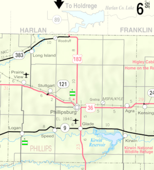
Phillips County covers a total area of about 895 square miles. Most of this is land, about 886 square miles. The rest, about 8.7 square miles, is water. This means about 1% of the county is covered by water.
Neighboring Counties
Phillips County shares its borders with several other counties:
- Harlan County, Nebraska (to the north)
- Franklin County, Nebraska (to the northeast)
- Smith County (to the east)
- Rooks County (to the south)
- Graham County (to the southwest)
- Norton County (to the west)
Protected Natural Areas
One important natural area in Phillips County is the Kirwin National Wildlife Refuge. This refuge helps protect many different kinds of wildlife and their homes.
People and Population
The number of people living in Phillips County has changed over the years. Here's a look at the population from different census counts:
| Historical population | |||
|---|---|---|---|
| Census | Pop. | %± | |
| 1880 | 12,014 | — | |
| 1890 | 13,661 | 13.7% | |
| 1900 | 14,442 | 5.7% | |
| 1910 | 14,150 | −2.0% | |
| 1920 | 12,505 | −11.6% | |
| 1930 | 12,159 | −2.8% | |
| 1940 | 10,435 | −14.2% | |
| 1950 | 9,273 | −11.1% | |
| 1960 | 8,709 | −6.1% | |
| 1970 | 7,888 | −9.4% | |
| 1980 | 7,406 | −6.1% | |
| 1990 | 6,590 | −11.0% | |
| 2000 | 6,001 | −8.9% | |
| 2010 | 5,642 | −6.0% | |
| 2020 | 4,981 | −11.7% | |
| 2023 (est.) | 4,761 | −15.6% | |
| U.S. Decennial Census 1790-1960 1900-1990 1990-2000 2010-2020 |
|||
In 2000, there were 6,001 people living in the county. Most people in Phillips County are White (98.25%). A small number of people are Black, Native American, or Asian. About 0.67% of the population were Hispanic or Latino.
The average age in the county in 2000 was 42 years old. About 24.5% of the people were under 18 years old.
Education
Phillips County has several school districts that serve its communities. These districts help students get a good education.
School Districts in Phillips County
- Thunder Ridge USD 110: This district covers Agra and parts of eastern Phillips County. It also reaches into Smith County.
- Northern Valley USD 212: This district includes Long Island and the northwestern part of the county. It also extends into Norton County.
- Phillipsburg USD 325: This district serves the city of Phillipsburg and nearby areas.
- Logan USD 326: This district covers the southwestern part of the county. It also extends into southeastern Norton County.
Communities
Phillips County is home to several cities and smaller communities. Some are incorporated cities, while others are unincorporated or even "ghost towns" that no longer have many residents.
Cities in Phillips County
- Agra
- Glade
- Kirwin
- Logan
- Long Island
- Phillipsburg (This is the main city and county seat)
- Prairie View
- Speed
Unincorporated Communities
These communities are not officially incorporated as cities. Some are even called "Census-Designated Places" (CDP) by the U.S. Census Bureau, which means they have clear boundaries for counting people.
div col end}}
Ghost Towns
These are former communities that are now mostly abandoned.
- Crow
- Dickeyville
- Goode
- Jimtown
- Luctor
- Matteson
- Myrtle
- Pleasant Green
- Powell
- Wagnerville
- West Cedar
See also
In Spanish: Condado de Phillips (Kansas) para niños


