
National Register of Historic Places listings in Pointe Coupee Parish, Louisiana facts for kids

Pointe Coupee Parish in Louisiana is home to many amazing old buildings and places. These special spots are listed on the National Register of Historic Places. This list helps protect important historical sites across the United States.
Imagine a special list of places that are super important to history! That's what the National Register of Historic Places is. In Pointe Coupee Parish, Louisiana, there are 32 of these incredible places. One of them is even a National Historic Landmark, which is an even higher honor! These places tell us stories about how people lived long ago. You can even see where some of these places are on a map if their exact location is shared.
Historic Treasures of Pointe Coupee Parish
Pointe Coupee Parish has many historic buildings, from old homes to important community places. Let's explore some of these cool spots!
Grand Old Homes and Plantations
Many of the historic places in Pointe Coupee Parish are beautiful old homes and plantations. These buildings often show us how people lived and worked many years ago.
Parlange Plantation House
The Parlange Plantation House is a very special place. It's located where Louisiana Highways 1 and 78 meet in Mix. This large, two-story French Colonial home was built around 1750 by Vincent de Ternant. Imagine, it's over 270 years old! During the American Civil War, both Union and Confederate generals used it as their military headquarters. Today, you can visit it by making an appointment.
.jpg)
White Hall Plantation House
The White Hall Plantation House is another beautiful old home. It's found east of Simmesport on Louisiana Highway 418. This mansion was built in the late 1840s and shows off Italianate and Greek Revival styles. It's thought that a famous architect named Henry Howard might have designed it. Like Parlange, it was also used during the Civil War. Union General Nathaniel Banks used it as his headquarters in 1863. The house was restored and opened to the public in 2013, so more people can learn about its history.

Other Notable Homes
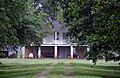
- Austerlitz: This home is located southeast of Louisiana Highway 1's junction with Louisiana Highway 78 in Oscar. It was listed in 1991.
- Jean Baptiste Bergeron House: Found at 13769 Chenal Road in Jarreau, this house was added to the list in 1994.
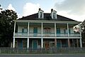
- Valmont Bergeron House: Also in Jarreau, on Louisiana Highway 414, this house became historic in 1992.
- Bonnie Glen: Southwest of New Roads on Louisiana Highway 1, this property was recognized in 1980.
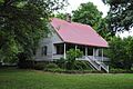
- Cherie Quarters Cabins: These cabins are on Major Lane in Oscar, about half a mile from Louisiana Highway 1. They were listed in 1995.

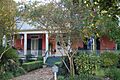
- Jacques Dupre House: Located at 13987 Chenal Road in Jarreau, this house joined the list in 2003.
- El Dorado Plantation House: This plantation house is on Bayou Maringouin, Louisiana Highway 77, in Livonia. It was listed in 1982.

- Glynnwood: You can find Glynnwood on Louisiana Highway 416 in Glynn. It was added to the list in 1982.

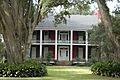
- Labatut: This historic site is at the junction of Louisiana Highways 10 and 420 in New Roads. It was listed in 1991.
- LeJeune House: Located at 507 East Main Street in New Roads, this house was recognized in 1978.

- Albin Major House: This house is at 1304 False River Road (Louisiana Highway 1) in New Roads. It was added in 1991.
- North Bend: West of Louisiana Highway 1's junction with Louisiana Highway 416, east of Oscar, North Bend was listed in 1992.

- Old Hickory: Southeast of LaCour, this property became historic in 1979.

- Riverlake: On Louisiana Highway 1 in Oscar, Riverlake was added to the list in 1983.

- Fannie Riche House: This house is near the junction of Louisiana Highway 420 and Louisiana Highway 10 in New Roads. It was listed in 1991.
.jpg)
- Saizon House: East of Louisiana Highway 414's junction with Louisiana Highway 413 in Jarreau, this house was recognized in 1991.
- Samson House: At 405 Richey Street in New Roads, this house joined the list in 1997.
- Valverda Plantation House: This house is at 2217 Louisiana Highway 977 in Maringouin. It was added in 2002.
- Wickliffe: East of Patin Duke Slough on Louisiana Highway 415 in New Roads, Wickliffe was listed in 1991.

Important Buildings in New Roads
The town of New Roads has several buildings that are important to the history of Pointe Coupee Parish.
Pointe Coupee Parish Courthouse
The Pointe Coupee Parish Courthouse is on Main Street in New Roads. Courthouses are very important buildings where laws are made and justice is served. This one was listed in 1981.

Pointe Coupee Parish Museum
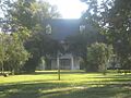
The Pointe Coupee Parish Museum is about 6 miles southwest of New Roads on Louisiana Highway 1. Museums are fantastic places to learn about the past, and this one helps tell the story of the parish. It was added to the list in 1980.

Poydras High School
Poydras High School is located at 500 West Main Street in New Roads. Schools are important community buildings, and this one has a special place in history, being listed in 1996.

First National Bank
The First National Bank building at 102 East Main Street in New Roads was listed in 2002. Banks play a big role in a town's economy and history.

Satterfield Motor Company Building
The Satterfield Motor Company Building at 108 East Main Street in New Roads was added to the list in 1994. This building tells us about the history of businesses and transportation in the area.

Historic Churches
Churches are often very old and beautiful buildings that are important to a community's history and culture.
St. Francis Chapel
St. Francis Chapel is northwest of New Roads on Louisiana Highway 10. This chapel was recognized as a historic place in 1979.

St. Stephen's Episcopal Church
St. Stephen's Episcopal Church is north of Innis, off Louisiana Highway 418. This church has been a historic site since 1974.
.jpg)
Images for kids
-
Austerlitz
-
Jean Baptiste Bergeron House
-
Valmont Bergeron House
-
Bonnie Glen
-
Jacques Dupre House
-
Labatut
-
Samson House
-
Valverda Plantation House


