
National Register of Historic Places listings in Powell County, Montana facts for kids

Have you ever wondered about old buildings and places that tell a story? In Powell County, Montana, there are many special spots that are listed on the National Register of Historic Places. This is like a special list kept by the United States government. It helps protect important buildings, places, and objects that have a lot of history.
When a place is on this list, it means it's recognized for its unique past, its cool architecture, or its connection to important events or people. It's a way to make sure these places are remembered and taken care of for future generations. In Powell County, there are 17 places on this list, and one of them is even a super important "National Historic Landmark"! Let's explore some of these amazing historic sites.
Contents
Historic Places in Powell County
Powell County is full of history, from old homes to big ranches and even a former prison. Each place has a unique story to tell about what life was like long ago in Montana.
Homes with History
Some of the places on the list are old houses that belonged to important people or show how people lived in the past.
Nick J. Bielenberg House
The Nick J. Bielenberg House is located in Deer Lodge, Montana. It was added to the list in 1979. It's a great example of the kind of homes built in the area a long time ago.
William E. Coleman House
Also in Deer Lodge, the William E. Coleman House joined the list in 1979. These homes help us imagine what daily life was like for families in the late 1800s or early 1900s.
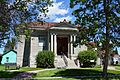
Deer Lodge American Women's League Chapter House
This special house in Deer Lodge was listed in 1982. It was a meeting place for the American Women's League, a group that helped women learn and grow. It shows how women worked together to make their communities better.
Important Buildings and Districts
Many places on the list are not just single houses, but whole areas or important public buildings.
Deer Lodge Central Business Historic District
Imagine walking through a town that looks much like it did over a hundred years ago! The Deer Lodge Central Business Historic District, listed in 2008, includes many old buildings in the heart of Deer Lodge. These buildings were once shops, offices, and other businesses that made the town busy and lively.
William K. Kohrs Free Memorial Library
The William K. Kohrs Free Memorial Library in Deer Lodge is a beautiful old building that became historic in 1979. Libraries are important places for learning and community, and this one has served the people of Deer Lodge for many years.
Montana Territorial and State Prison
The old Montana Territorial and State Prison in Deer Lodge is a very interesting historic site, listed in 1976. It was once the main prison for the state. Today, parts of it are a museum where you can learn about its long and sometimes tough history.
Rialto Theater
The Rialto Theater in Deer Lodge, listed in 1998, is a classic movie theater. These old theaters are special because they were once the main place for entertainment and community gatherings before TVs were common.
Trask Hall (College of Montana)
Trask Hall is a building that was part of the College of Montana in Deer Lodge. It was listed in 1982. This building reminds us of the early days of education in Montana and how important colleges were for young people.
Ranches and Rural Sites
Powell County has a lot of open land, and some of its historic places are large ranches or sites out in the countryside.
Charter Oak Mine and Mill
Near Elliston, Montana, the Charter Oak Mine and Mill was listed in 2001. This site tells the story of Montana's mining past, which was a huge part of its early economy. Miners worked hard to find valuable minerals here.
Fitzpatrick Ranch Historic District
The Fitzpatrick Ranch, located northwest of Avon, Montana, became a historic district in 1981. Ranches like this one were vital for raising cattle and providing food for the growing population. They show the history of farming and ranching in Montana.
Grant-Kohrs Ranch National Historic Site
This is one of the most famous historic places in Powell County! The Grant-Kohrs Ranch is so important that it's a "National Historic Landmark." It was listed in 1972. This ranch was one of the biggest and most important cattle ranches in the American West. It shows what life was like for cowboys and ranchers in the 1800s. You can visit it today and see how a working ranch operated long ago.
Prison Brickyard Historic District
Just south of Deer Lodge, the Prison Brickyard Historic District was listed in 1988. This was where bricks were made, often by prisoners, to build many of the structures in the area, including parts of the prison itself. It's a unique look into how building materials were produced.
Bridges and Transportation
Transportation was key to connecting communities in Montana, and some historic places are bridges that helped people travel.
Conley Street Bridge
The Conley Street Bridge crosses the Clark Fork River in Deer Lodge and was listed in 2011. This bridge is a great example of early engineering and how important bridges were for getting across rivers.
Little Blackfoot River Bridge
Near Avon, the Little Blackfoot River Bridge was added to the list in 2010. Bridges like this one were crucial for connecting towns and allowing people and goods to move around the state.
MacDonald Pass Airway Beacon
The MacDonald Pass Airway Beacon, near Helena, Montana, was listed in 2014. This beacon was part of an early system to guide airplanes at night, showing how aviation developed in the United States.
Northern Pacific Railroad Completion Site, 1883
Near Goldcreek, Montana, this site was listed in 1983. It marks the spot where the Northern Pacific Railroad was completed in Montana in 1883. The railroad was a huge deal because it connected the West to the rest of the country, bringing new people and goods and changing everything!
Images for kids
-
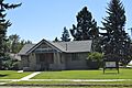
The Deer Lodge American Women's League Chapter House.
-
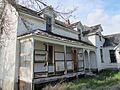
The Fitzpatrick Ranch house.
-
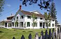
The historic ranch house at Grant-Kohrs Ranch.
-
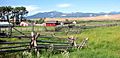
A view of the Grant-Kohrs Ranch National Historic Site.
-
The William K. Kohrs Free Memorial Library.
-
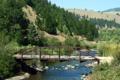
The Little Blackfoot River Bridge.
-
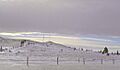
The MacDonald Pass Airway Beacon.
-
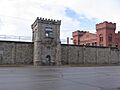
The old Montana Territorial and State Prison.
-
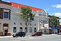
The Rialto Theater in Deer Lodge.


_-_Powell_County,_Montana.png)


