
National Register of Historic Places listings in Randolph County, North Carolina facts for kids

Have you ever wondered about the old buildings and places in your town? Many of them have amazing stories! This article explores some of the special historic places in Randolph County, North Carolina. These places are so important that they are listed on the National Register of Historic Places. This is like a special list kept by the United States government to protect and celebrate buildings, sites, and objects that are important to history.
Contents
Exploring Randolph County's Historic Places
Randolph County is full of history, from old schools and courthouses to unique pottery sites and covered bridges. Each place tells a part of the story of how people lived and worked long ago. By learning about these sites, we can understand more about the past and why these places are still special today.
What is the National Register of Historic Places?
The National Register of Historic Places is the official list of the nation's historic places worth saving. It helps us remember and protect important parts of American history. When a place is on this list, it means it has special historical, architectural, or archaeological value. It could be a building where something important happened, a unique type of architecture, or even a place where ancient tools were found.
Famous Historic Buildings in Asheboro
Asheboro, the county seat of Randolph County, has several buildings on the National Register. These buildings show how the town grew and changed over time.
Central School: A Place of Learning
The Central School building, located at 414 Watkins Street, was added to the National Register in 1993. Schools are often at the heart of a community, and this building likely saw many generations of students learn and grow. It represents the importance of education in Asheboro's history.
Randolph County Courthouse: A Center of Justice
The Randolph County Courthouse on Worth Street was listed in 1979. Courthouses are very important buildings in any county. They are where laws are made, justice is served, and many official records are kept. This courthouse has been a central point for the county's government and community life for many years.
Sunset Theater: Where Movies Came Alive
The Sunset Theater at 232-236 Sunset Avenue joined the list in 2011. Movie theaters were once grand places where people gathered to watch films and enjoy entertainment. The Sunset Theater reminds us of a time when going to the movies was a big event for families and friends in Asheboro.
Historic Districts: Preserving Whole Neighborhoods
Sometimes, it's not just one building that's historic, but a whole group of buildings or an entire area. These are called historic districts. They show how a town or community looked and functioned in the past.
Liberty Historic District: A Town's Story
The Liberty Historic District in Liberty was added to the National Register in 2000. This district includes many buildings along the west side of the Norfolk & Southern Railroad. It gives us a peek into what a busy town center looked like in the past, with homes, shops, and businesses all close together.

Franklinville Historic District: River Town History
The Franklinville Historic District in Franklinville was listed in 1984. This area is roughly bounded by the Deep River, Sunrise Avenue, Clark Street, and Greensboro Road. It shows how communities developed around important natural features like rivers, which were often used for transportation and power for mills.
Unique Historic Sites: From Pottery to Bridges
Randolph County also has some very unique historic sites that tell different kinds of stories.
William Dennis Pottery Kiln: Old Craftsmanship
The William Dennis Pottery Kiln and House Site near Randleman was added to the National Register in 2014. A kiln is a special oven used to bake clay to make pottery. This site shows us where a potter named William Dennis worked and lived. It gives us a look into the history of craftsmanship and how people made useful and beautiful items long ago.
Pisgah Community Covered Bridge: A Bridge from the Past
The Pisgah Community Covered Bridge southeast of Pisgah was listed in 1972. Covered bridges are very special because they are rare today. They were built with roofs to protect the wooden structure from weather, making them last longer. This bridge is a beautiful example of old engineering and a reminder of how people traveled in the past.

Images for kids
-
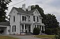
The Moses Hammond House in Archdale.
-
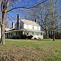
The Lewis-Thornburg House.
-
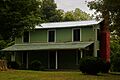
The Marley House.
-
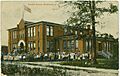
The Randleman Graded School around 1908.
-
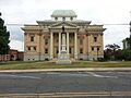
The Randolph County Courthouse in 2013.
-
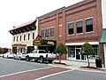
The Sunset Theater in 2013.


