
National Register of Historic Places listings in Rowan County, Kentucky facts for kids

Have you ever wondered about old buildings and places that are really important to history? In Rowan County, Kentucky, there are many special spots that are listed on the National Register of Historic Places. This is like a special list kept by the United States government. When a building or place is on this list, it means it's super important because of its history, amazing design, or what it teaches us about the past.
Being on this list helps protect these places so they can be enjoyed and learned from for many years to come. In Rowan County, there are 13 different places that have earned a spot on this important list. Let's explore some of them!
Contents
Historic Buildings in Rowan County
Rowan County is home to several buildings that tell stories of the past. These places are recognized for their historical value.
Voting Houses: A Look at Local History
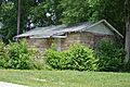
Many of the historic places in Rowan County are old "voting houses." These were small buildings where people used to go to cast their votes during elections. They are important because they show us how voting worked in the past and how communities came together. Nine of these voting houses are on the National Register!
- Brushy Voting House No. 6: You can find this old voting house where Kentucky Route 32 and Spruce Street meet in Morehead. It was added to the list in 1998.
- Cranston Voting House No. 12: This one is located near the junction of Clear Fork Road and Kentucky Route 377. It also became a historic site in 1998.
- Farmers Voting House No. 2: This voting house is on Kentucky Route 801, just a bit south of Farmers. It joined the list in 1998.
- Haldeman Voting House No. 8: Located on Kentucky Route 174, this voting house was recognized in 1998.
- Hayes Voting House No. 16: You can find this one on Little Perry Road, close to Kentucky Route 60. It was added to the list in 1998.
- Hogtown Voting House No. 4: This historic voting house is on Williamstown Road and was listed in 1998.
- Morehead Voting House No. 7: This voting house is on Clearfield Street in Morehead. It was added to the list in 1998.
- Morehead Voting House No. 10: Located at the junction of Knapp and West 2nd Street, this voting house also became a historic site in 1998.
- Pine Grove Voting House No. 5: This voting house is on Rock Fork Road, about half a mile north of Kentucky Route 377. It was listed in 1998.
- Plank Voting House No. 15: You can find this one at 815 Plank Chapel Road. It was added to the list in 1998.
These voting houses are special because they remind us of how important it is for people to vote and be part of their community's decisions.
Morehead Chesapeake and Ohio Railway Freight Depot
This old building, located at 130 East 1st Street in Morehead, used to be a busy place where goods were loaded onto and off trains. It was part of the Chesapeake and Ohio Railway. This depot was added to the National Register in 2016. It's a great example of how trains helped move goods and connect communities in the past.
Morehead State University
Did you know that an entire university campus can be a historic place? Morehead State University in Morehead is listed as a historic district. This means that a whole area, including many of its buildings, is considered important. The university campus is bounded by University Boulevard, Battson Avenue, and Ward Oates Drive. It was added to the National Register in 1994.
Rowan County Courthouse
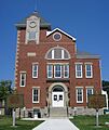
The Rowan County Courthouse is a very important building in Morehead. It's located on Main Street and is where many local government activities happen. This courthouse was first added to the National Register in 1983. Later, in 2017, its historic area was made even bigger to include more of its important surroundings. Courthouses are often central to a town's history and community life.
Images for kids
-
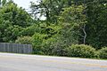
Brushy Voting House No. 6
-
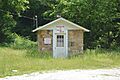
Haldeman Voting House No. 8
-
Hayes Voting House No. 16
-
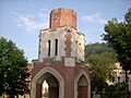
Morehead State University
-

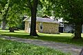
Morehead Voting House No. 7
-
Morehead Voting House No. 10
-
Rowan County Courthouse


