
National Register of Historic Places listings in Simpson County, Kentucky facts for kids

Have you ever wondered about old buildings and places that tell a story? In Simpson County, Kentucky, there are many special spots that are listed on the National Register of Historic Places. This is like a special list kept by the United States government. It helps protect important buildings, sites, and districts. These places are chosen because they have a lot of history. They might be very old, beautiful, or important to local and national events.
When a place is on this list, it means it's recognized for its historical value. It helps people learn about the past and keep these treasures safe for the future. In Simpson County, there are 14 such places. They include old homes, schools, and even whole parts of towns! Let's explore some of these amazing historic sites.
Contents
Exploring Simpson County's Historic Places
Simpson County is home to many places that have played a part in history. These sites are important for understanding the area's past. They show us how people lived, worked, and built their communities long ago.
Historic Homes and Buildings
Many of the places on the list are beautiful old homes. These houses often show different styles of architecture. They also tell stories about the families who lived there.
The Cedars
The Cedars is a historic home located at 812 East Cedar Street in Franklin, Kentucky. It was added to the National Register in 1996. This house is a great example of the older homes in the area.
Duncan House
The Duncan House is another important home in Franklin. You can find it at 301 North Main Street. It was recognized as historic in 1982.
Goodnight House
The Goodnight House, at 201 South Main Street, was listed in 1977. It's one of the older listings in the county.
Hampton Hall
Hampton Hall is a large property located outside of Franklin, on Bowling Green Road. It became a historic site in 1996.
Hargis House
The Hargis House is at 300 East Cedar Street in Franklin. It was added to the list in 1996.
Randolph Gilbert Moore House
The Randolph Gilbert Moore House is another historic home. It's located at 321 South College Street. This house was also listed in 1996.
Octagon Hall
One very unique building is Octagon Hall. It's northeast of Franklin on U.S. Route 31W. This house is special because it has eight sides! It was built in the 1800s and played a role during the American Civil War. It was added to the National Register in 1980.
Triple Pine Farm
Triple Pine Farm is another historic property. It's located at 5945 Bowling Green Road. This farm was added to the list in 1996.
Important Public Buildings
Besides homes, some public buildings are also on the list. These buildings were important for the community.
Franklin Grade and High School
The old Franklin Grade and High School building is at 513 West Madison Street. This school served many students over the years. It was listed as a historic place in 2010.
Simpson County Courthouse
The Simpson County Courthouse is a very important building for the county. It's located on Kentucky Route 73 in Franklin. Courthouses are where local government takes place. This one was added to the list in 1980.
Historic Districts
Sometimes, not just one building, but a whole area is considered historic. These are called "historic districts." They often have many old buildings that together show what a town looked like in the past.
Franklin Downtown Commercial District
The Franklin Downtown Commercial District includes parts of Main and College Streets. This area is the heart of downtown Franklin. It has many old shops and businesses. It was listed in 1983.
Harristown Historic District
The Harristown Historic District is another important area in Franklin. It's roughly bounded by Walker Avenue, Bell Street, West Washington Street, and West Street. This district was recognized in 1996.
West Cedar Street Historic District
The West Cedar Street Historic District covers parts of West Cedar Street. It's between North High and West Streets. This district was also added to the list in 1996.
Unique Natural Sites
Not all historic places are buildings. Some are natural sites that have historical importance.
Sinking Creek Cave System
The Sinking Creek Cave System is a natural wonder in Simpson County. Caves can be important for history, science, or even local legends. This cave system was listed in 1983. Its exact location is kept private to protect it.
Images for kids
-
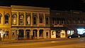
The Franklin Downtown Commercial District
-
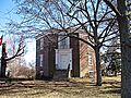
Octagon Hall, a unique eight-sided house
-
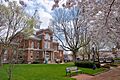
The historic Simpson County Courthouse


