
National Register of Historic Places listings in St. Clair County, Alabama facts for kids

Have you ever wondered about the old buildings and places around you? Some of them are super important because they tell us stories about the past! In St. Clair County, Alabama, there are many special spots that are listed on the National Register of Historic Places. This is like a special list kept by the United States government. It helps protect places that are important to history, architecture, or culture.
When a place is on this list, it means it's recognized as a valuable part of our country's heritage. It also helps make sure these places are looked after for future generations, like you! St. Clair County has 15 different places and areas that have earned this special recognition. Let's explore some of them and learn about their cool histories!
Contents
Historic Homes in Ashville
Ashville, one of the county seats of St. Clair County, is home to several historic houses. These homes give us a peek into how people lived many years ago.
The John Ash House
The John Ash House was added to the National Register in 1991. It's located west of Ashville. This house is a great example of the kind of homes built in the area a long time ago.
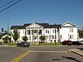
Dr. James J. Bothwell House
Another interesting home in Ashville is the Dr. James J. Bothwell House, listed in 1982. Dr. Bothwell was likely an important person in the community, and his house shows us the style of buildings from his time.
The Inzer House
The Inzer House on Hartford Avenue in Ashville became a historic listing in 1973. It's another beautiful example of the older homes that make Ashville special.
The Looney House
About five miles west of Ashville, you'll find the Looney House, which was added to the Register in 1974. This house has stood for many years and holds many stories within its walls.
Rev. Thomas Newton House
The Rev. Thomas Newton House, listed in 1991, is south of U.S. Route 411 near Ashville. It reminds us of the people who helped shape the community's early days.
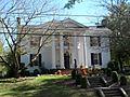
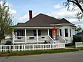
Judge Elisha Robinson House
The Judge Elisha Robinson House, added in 1991, is another significant home in Ashville. Judges often played a big role in their communities, and their homes reflect that importance.
Historic Districts: Whole Neighborhoods of History
Sometimes, it's not just one building that's historic, but a whole group of buildings or a neighborhood. These are called "historic districts."
Ashville Historic District
The Ashville Historic District was recognized in 2005. This area includes many important buildings that show how Ashville grew over time. Walking through this district is like taking a trip back in time!
Avondale Mill Historic District in Pell City
In Pell City, the Avondale Mill Historic District was listed in 2000. This district is important because it tells the story of the Avondale Mill, which was a big part of Pell City's history and economy. Mill towns often had unique layouts and buildings for workers and their families.
Old Pell City Historic District
Also in Pell City, the Old Pell City Historic District was added in 2001. This area shows the older parts of the city, giving us clues about its early development.
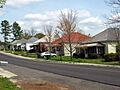
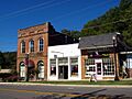
Pell City Downtown Historic District
The Pell City Downtown Historic District was listed in 2001. This district covers the main part of downtown Pell City, where many businesses and important buildings have stood for years. It shows how the city's center developed.
Springville Historic District
Springville also has its own special area, the Springville Historic District, listed in 1997. This district includes many buildings that show the history and growth of Springville.
Other Important Historic Sites
St. Clair County has other unique historic places beyond homes and districts.
Fort Strother Site
Near Ohatchee, you'll find the Fort Strother Site, which was listed in 1972. This site is very important because it was a fort built during the War of 1812. It played a role in early American history in Alabama.
Jacob Green House
East of Ashville, the Jacob Green House was added to the Register in 1980. This house is another example of the early architecture and settlement patterns in the county.
Presley Store
In Springville, the Presley Store was listed in 1983. Old stores like this were often the heart of a community, where people gathered, bought supplies, and shared news. It gives us an idea of what shopping and community life were like long ago.
St. Clair Springs
The area known as St. Clair Springs was listed in 1976. This location was once a popular resort area, known for its natural springs. People would visit for health and relaxation, making it an important part of the county's social history.
These 15 places and districts in St. Clair County are not just old buildings; they are pieces of history that help us understand the past and appreciate the journey of the people who lived there before us.
Images for kids
-
The historic St. Clair County Courthouse, part of the Ashville Historic District.
-
A building in the Avondale Mill Historic District in Pell City.
-
The Dr. James J. Bothwell House in Ashville.
-
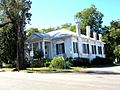
The historic Inzer House in Ashville.
-
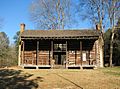
The Looney House near Ashville.
-
The Fowler House, part of the Old Pell City Historic District.
-
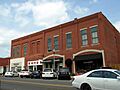
A street view in the Pell City Downtown Historic District.
-
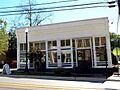
The historic Presley Store in Springville.
-
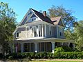
The Judge Elisha Robinson House in Ashville.
-
Main Street in the Springville Historic District.


